You can use the Google Mirror API to
observe the user's location in timeline items, request their
[last known location](https://developers.google.com/glass/v1/reference/locations/get) directly, and subscribe
to periodic location updates. You can also deliver pre-rendered map images
in timeline cards by giving the Mirror API the coordinates to draw.
> [!NOTE]
> **Note:** Retrieving users' location requires the additional `https://www.googleapis.com/auth/glass.location` scope.
## Retrieving the latest known location
To [retrieve](https://developers.google.com/glass/v1/reference/locations/get) the latest known location for
the current user, send a `GET` request to the REST endpoint:
### Raw HTTP
GET /mirror/v1/locations/ HTTP/1.1
Authorization: Bearer {auth token}
## Subscribing to location updates
Similar to [subscribing to timeline updates](https://developers.google.com/glass/subscriptions),
you can subscribe to location updates by subscribing to the `locations`
collection.
### Raw HTTP
POST /mirror/v1/subscriptions HTTP/1.1
Authorization: Bearer {auth token}
Content-Type: application/json
Content-Length: {length}
{
"collection": "locations",
"userToken": "harold_penguin",
"verifyToken": "random_hash_to_verify_referer",
"callbackUrl": "https://example.com/notify/callback"
}
> [!NOTE]
> **Note:** At this time, location notifications are sent every 10 minutes.
## Rendering maps on timeline cards
The Google Mirror API can render maps for you and overlay markers and lines to
signify important places and paths. Use the `glass://map` URI to request
a map. Here's an example:
> [!NOTE]
> **Note:** Always specify the width and height of the image in the `` tag as well. This prevents reflows as the map image is being rendered.
Here is a description of required parameters:
- `w` - The width in pixels of the returned map image
- `h` - The height in pixels of the returned map image
Only one of the items in the following list are additionally required,
but you can specify all of them:
- `center` and `zoom` - The center (latitude,longitude) of the map to render at and the zoom level. See [Zoom Levels](https://developers.google.com/maps/documentation/staticmaps#Zoomlevels) for more information.
- `marker` - Specify the pin markers to draw at the specified coordinates. The marker parameter takes a marker type (`0` indicates a `pin` and `1`, the current location), the latitude coordinate, and the longitude coordinate. The map automatically centers and zooms around the markers you create if you don't explicitly specify `center` and `zoom`.
- `polyline` - Specify the polyline coordinates to represent a path on the map. Each polyline consists of a width and color followed by the vertices in the polyline. For example: `polyline=8,ffff0000;47.6,-122.34,47.62,-122.40` specifies an 8-pixel wide red line between (`47.6,-122.34`) and (`47.62,-122.40`). The map is automatically centered and zoomed to fit the polyline if you don't explicitly specify `center` and `zoom`.
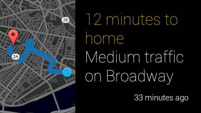
The following example shows a best practice of how to display a map
image with some text and what it looks like:
12 minutes to home
Medium traffic on Broadway
> [!NOTE]
> **Note:** You can omit the color and width of the polyline like in this example. The map is rendered using the default color and width in this situation.