Select platform: [Android](https://developers.google.com/maps/documentation/android-sdk/configure-map.md.txt "View this page for the Android platform docs.") [iOS](https://developers.google.com/maps/documentation/ios-sdk/configure-map.md.txt "View this page for the iOS platform docs.")
This document describes how to configure a map that was added to an Android app
using the Maps SDK for Android.
## Overview
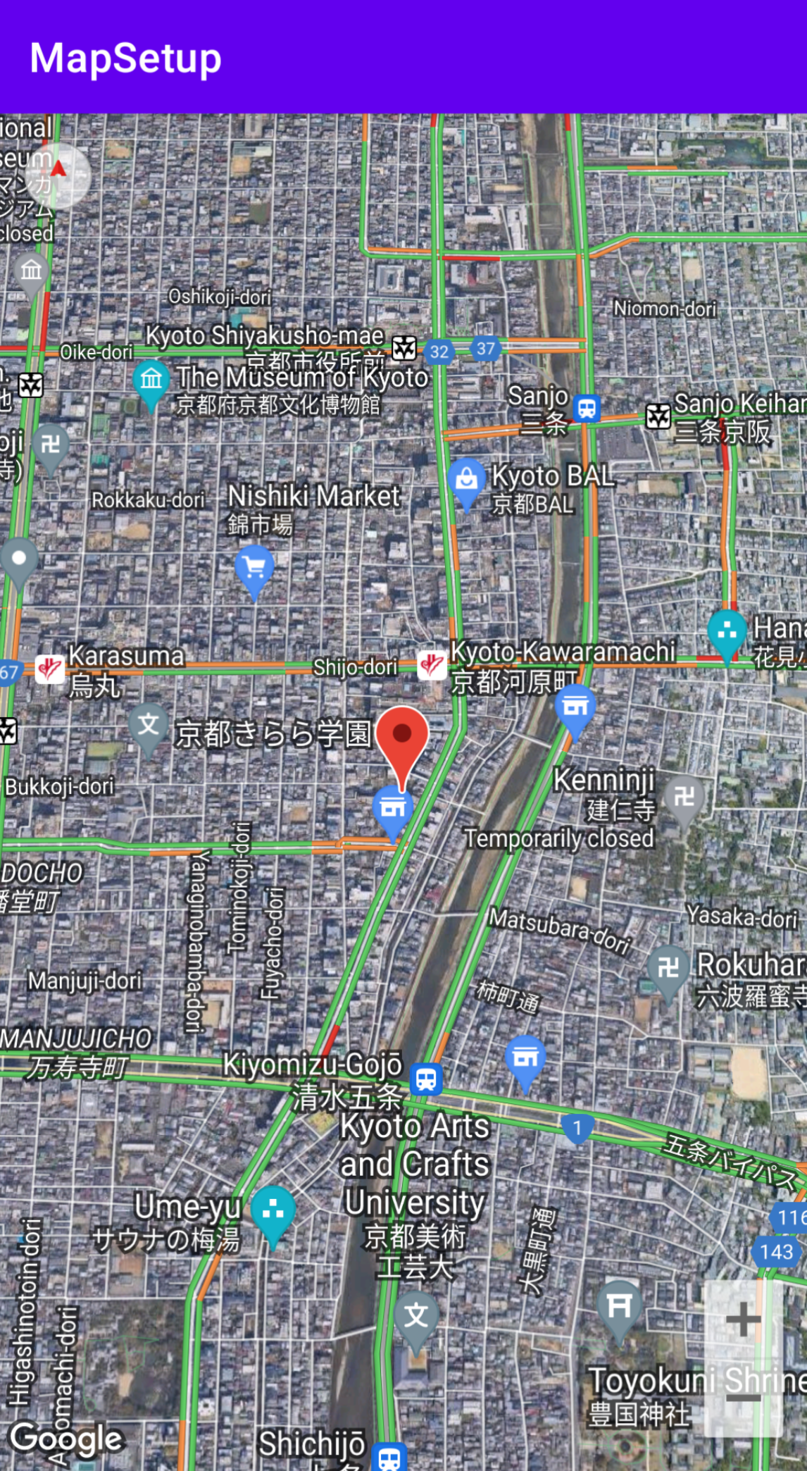
After you add a map to your app, you can configure the initial and runtime
settings of the map. The initial settings need be configured based on whether
you added the map container ([`SupportMapFragment`](https://developers.google.com/maps/documentation/android-sdk/reference/com/google/android/libraries/maps/SupportMapFragment.md.txt) or
[`MapView`](https://developers.google.com/maps/documentation/android-sdk/reference/com/google/android/libraries/maps/MapView.md.txt)) statically or dynamically. If the map container was
added statically, you can configure the initial map settings in the layout file.
If it was added dynamically, you can configure the initial settings in the
[`OnCreate`](http://developer.android.com/reference/android/app/Activity.html#onCreate(android.os.Bundle)) callback with a [`GoogleMapOptions`](https://developers.google.com/maps/documentation/android-sdk/reference/com/google/android/libraries/maps/GoogleMap.md.txt)
object.
For details about adding a map container, see the [Add a map](https://developers.google.com/maps/documentation/android-sdk/map.md.txt).
The initial map settings include the following:
- The camera position, including: location, zoom, bearing and tilt. See [Camera and View](https://developers.google.com/maps/documentation/android-sdk/views.md.txt) for details on camera positioning.
- The [map type](https://developers.google.com/maps/documentation/android-sdk/configure-map.md.txt#maptype).
- The [UI components](https://developers.google.com/maps/documentation/android-sdk/controls.md.txt#ui_controls) to display, such as the zoom buttons and compass.
- The [gestures](https://developers.google.com/maps/documentation/android-sdk/controls.md.txt#map_gestures) to enable.
- Whether [lite mode](https://developers.google.com/maps/documentation/android-sdk/lite.md.txt) is enabled.
At runtime you can configure these settings and some addition settings by
updating the `GoogleMap` object in the [`onMapReady`](https://developers.google.com/maps/documentation/android-sdk/reference/com/google/android/libraries/maps/OnMapReadyCallback.md.txt)
callback. The additional settings are configured through the methods of the
`GoogleMap` class, such as those that configure the
[traffic layer](https://developers.google.com/maps/documentation/android-sdk/configure-map.md.txt#trafficlayer) and [map padding](https://developers.google.com/maps/documentation/android-sdk/configure-map.md.txt#mappadding).
## Example
In the example code below and the [screenshot](https://developers.google.com/maps/documentation/android-sdk/configure-map.md.txt#overview) above, the map is
configured with the following settings.
The initial settings are configured in the [layout file](https://developer.android.com/guide/topics/ui/declaring-layout):
- Enable zoom controls.
- Enable rotate gesture controls.
- Set the map tilt to 30.
The runtime settings:
- Center the camera on Kyoto Japan.
- Enable the hybrid map type.
- Turn on the traffic layer.
### Initial settings
```java
```
### Runtime settings
```java
package com.example.mapsetup;
import androidx.appcompat.app.AppCompatActivity;
import android.os.Bundle;
import com.google.android.gms.maps.CameraUpdateFactory;
import com.google.android.gms.maps.GoogleMap;
import com.google.android.gms.maps.OnMapReadyCallback;
import com.google.android.gms.maps.SupportMapFragment;
import com.google.android.gms.maps.model.LatLng;
import com.google.android.gms.maps.model.MarkerOptions;
public class MainActivity extends AppCompatActivity implements OnMapReadyCallback {
@Override
protected void onCreate(Bundle savedInstanceState) {
super.onCreate(savedInstanceState);
setContentView(R.layout.activity_main);
SupportMapFragment mapFragment = (SupportMapFragment) getSupportFragmentManager()
.findFragmentById(R.id.map);
mapFragment.getMapAsync(this);
}
// Update the map configuration at runtime.
@Override
public void onMapReady(GoogleMap googleMap) {
// Set the map coordinates to Kyoto Japan.
LatLng kyoto = new LatLng(35.00116, 135.7681);
// Set the map type to Hybrid.
googleMap.setMapType(GoogleMap.MAP_TYPE_HYBRID);
// Add a marker on the map coordinates.
googleMap.addMarker(new MarkerOptions()
.position(kyoto)
.title("Kyoto"));
// Move the camera to the map coordinates and zoom in closer.
googleMap.moveCamera(CameraUpdateFactory.newLatLng(kyoto));
googleMap.moveCamera(CameraUpdateFactory.zoomTo(15));
// Display traffic.
googleMap.setTrafficEnabled(true);
}
}
```
## Before you begin
Before you begin, you can set up a project and add a basic map through the
following options:
- Create an app using the Maps template for Android Studio. The Maps template
automatically configures your project and adds a basic map. A fragment is used
as the map container and it is added statically. For details, see the
[quickstart](https://developers.google.com/maps/documentation/android-sdk/start.md.txt).
- Manually [configure your project](https://developers.google.com/maps/documentation/android-sdk/config.md.txt) for the SDK and
[add a basic map](https://developers.google.com/maps/documentation/android-sdk/map.md.txt). This allows you to use any Android template and add a
map to an existing app.
## Configure a map after adding it statically
This section describes how to set the initial state of the map if you added it
statically to your layout file.
The Maps SDK for Android defines a set of [custom XML attributes](https://developer.android.com/training/custom-views/create-view.html#customattr) for a
`SupportMapFragment` or a `MapView` that you can use to configure the initial
state of the map directly from the layout file. The following attributes
are defined:
- `mapType` --- The type of map to display. Valid values include: `none`,
`normal`, `hybrid`, `satellite` and `terrain`.
- `cameraTargetLat`, `cameraTargetLng`, `cameraZoom`, `cameraBearing`,
`cameraTilt` --- The initial camera position. See the
[camera and views](https://developers.google.com/maps/documentation/android-sdk/views.md.txt) guide for details.
- `uiZoomControls`, `uiCompass` --- Specifies whether zoom controls and the
compass are displayed. See [`UiSettings`](https://developers.google.com/maps/documentation/android-sdk/reference/com/google/android/libraries/maps/UiSettings.md.txt) for details.
- `uiZoomGestures`, `uiScrollGestures`, `uiRotateGestures`, `uiTiltGestures` ---
Specifies whether specific gestures are enabled. See
[`UiSettings`](https://developers.google.com/maps/documentation/android-sdk/reference/com/google/android/libraries/maps/UiSettings.md.txt) for details.
- `zOrderOnTop` --- Indicates whether the surface of the map view is displayed on
top of the map window, map controls, and any object in the window. See
[SurfaceView.setZOrderOnTop(boolean)](https://developer.android.com/reference/android/view/SurfaceView.html#setZOrderOnTop(boolean)) for details.
- `useViewLifecycle` --- Only valid with a `SupportMapFragment` object. Specifies
whether the lifecycle of the map should be tied to the fragment's view or the
fragment itself. See the [reference documentation](https://developers.google.com/maps/documentation/android-sdk/reference/com/google/android/libraries/maps/GoogleMapOptions.md.txt#public-boolean-getuseviewlifecycleinfragment) for
details.
- `liteMode` --- `true` to enable [lite mode](https://developers.google.com/maps/documentation/android-sdk/lite.md.txt); otherwise, `false`.
- `mapColorScheme` --- Specifies the color scheme for a normal and terrain map.
Values include `light`, `dark`, and `follow_system` (default) meaning use the
current system setting based on the device setting for `UI_NIGHT_MODE_MASK`.
For more information, see [Map color scheme](https://developers.google.com/maps/documentation/android-sdk/configure-map.md.txt#map_color_scheme).
In order to use these custom attributes within your layout file, it must
include the following namespace declaration. You can choose any namespace, it
doesn't have to be `map`:
xmlns:map="http://schemas.android.com/apk/res-auto"
You can then add the attributes with a `map:` prefix into your layout file.
The following layout file configures a `SupportMapFragment` object with custom
map attributes. The same attributes can be applied to a `MapView` object as
well.
> [!NOTE]
> **Note:** If you are using the Maps SDK for Android with a Google Maps Platform Premium Plan license, you must prefix each attribute with `m4b_`. For example, when specifying the map type attribute, use `m4b_mapType` instead of `mapType`. When specifying zoom controls, use `m4b_uiZoomControls` instead of `uiZoomControls`.
## Configure a map after adding it dynamically
This section describes how to set the initial state of the map if you added it
to your app dynamically.
If you added a `SupportMapFragment` or `MapView` dynamically, then you can
set the initial state of the map in a `GoogleMapOptions` object. The
options available are the same options that are available in the layout file.
You can create a `GoogleMapOptions` as follows:
### Kotlin
```kotlin
val options = GoogleMapOptions()
```
### Java
```java
GoogleMapOptions options = new GoogleMapOptions();
```
And then configure it as follows:
### Kotlin
```kotlin
options.mapType(GoogleMap.MAP_TYPE_SATELLITE)
.compassEnabled(false)
.rotateGesturesEnabled(false)
.tiltGesturesEnabled(false)
```
### Java
```java
options.mapType(GoogleMap.MAP_TYPE_SATELLITE)
.compassEnabled(false)
.rotateGesturesEnabled(false)
.tiltGesturesEnabled(false);
```
To apply these options when you are creating a map, do one of the following:
- If you are using a `SupportMapFragment`, use the [`SupportMapFragment.newInstance(GoogleMapOptions options)`](https://developers.google.com/maps/documentation/android-sdk/reference/com/google/android/libraries/maps/SupportMapFragment.md.txt#public-static-supportmapfragment-newinstance-googlemapoptions-options) static factory method to construct the fragment and pass in your settings.
- If you are using a `MapView`, use the [`MapView(Context, GoogleMapOptions)`](https://developers.google.com/maps/documentation/android-sdk/reference/com/google/android/libraries/maps/MapView.md.txt#public-mapview-context-context,-googlemapoptions-options) constructor and pass in your settings.
## Localize your map
When you add a `MapView` or `SupportMapFragment` to your app, textual elements
on the map are displayed in the appropriate language based on the user's device
settings and location. You can restrict the languages used by your app to a
subset of all supported languages, by adding a `resConfigs` item to your Gradle
file. This is useful for stripping out unused languages, and also reduces your
app's binary size. For example:
defaultConfig {
resConfigs "en", "fr", "es", "zh", "de", "ja", "ru", "ko", "pt", "in"
}
Read more about [localizing your Android app](https://developer.android.com/guide/topics/resources/localization).
## Set up the traffic layer
You can display traffic data on your map by enabling the traffic layer. You can
enable and disable the traffic layer by calling the
[`setTrafficEnabled()`](https://developers.google.com/android/reference/com/google/android/gms/maps/GoogleMap.md.txt#setTrafficEnabled(boolean))
method, and you can determine whether the traffic layer is on by calling the
[`isTrafficEnabled()`](https://developers.google.com/android/reference/com/google/android/gms/maps/GoogleMap.md.txt#isTrafficEnabled())
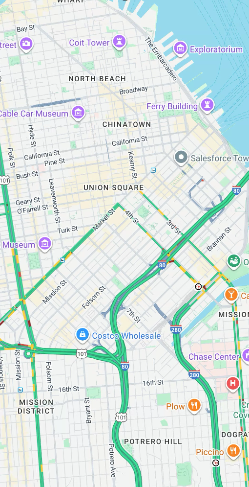
method. The following screenshot displays a map with the traffic layer enabled.
## Set up the transit layer
You can display transit data on your map by enabling the transit layer. You can
enable and disable the transit layer by calling the
[`setTransitEnabled()`](https://developers.google.com/android/reference/com/google/android/gms/maps/GoogleMap.md.txt#setTransitEnabled(boolean))
method, and you can determine whether the transit layer is on by calling the
[`isTransitEnabled()`](https://developers.google.com/android/reference/com/google/android/gms/maps/GoogleMap.md.txt#isTransitEnabled())
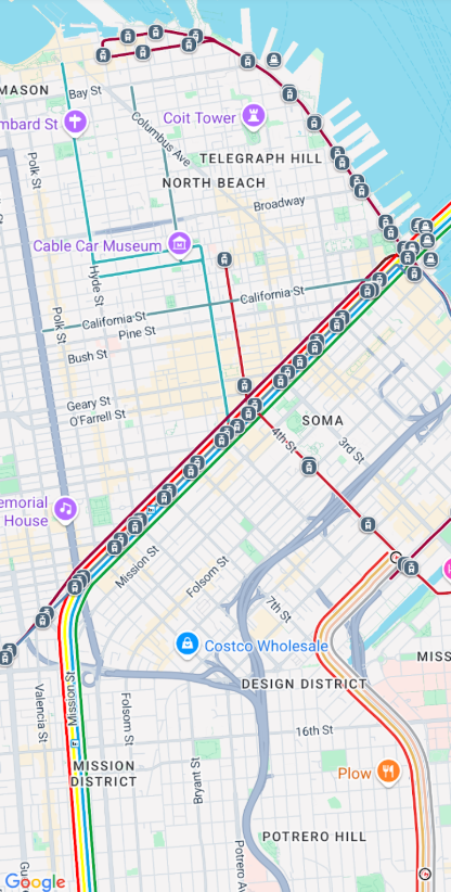
method. The following screenshot displays a map with the transit layer enabled.
## Set the map type
To set the map type, call the [`setMapType`](https://developers.google.com/maps/documentation/android-sdk/reference/com/google/android/libraries/maps/GoogleMap.md.txt#public-void-setmaptype-int-type) method.
For example, to display a satellite map:
### Kotlin
```kotlin
// Sets the map type to be "hybrid"
map.mapType = GoogleMap.MAP_TYPE_HYBRID
```
### Java
```java
// Sets the map type to be "hybrid"
map.setMapType(GoogleMap.MAP_TYPE_HYBRID);
```
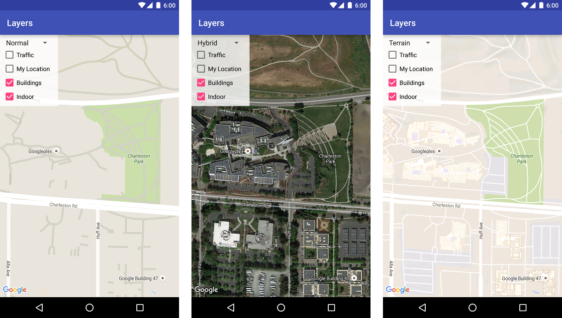
The following image compares the normal, hybrid and terrain map types:
## Set up 3D buildings
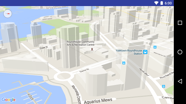
Many cities, when viewed close up, will have 3D buildings visible, as viewable
in the below picture of Vancouver, Canada. You can disable the 3d buildings by
calling
[`GoogleMap.setBuildingsEnabled(false)`](https://developers.google.com/android/reference/com/google/android/gms/maps/GoogleMap.md.txt#setBuildingsEnabled(boolean)).
## Set up indoor map settings
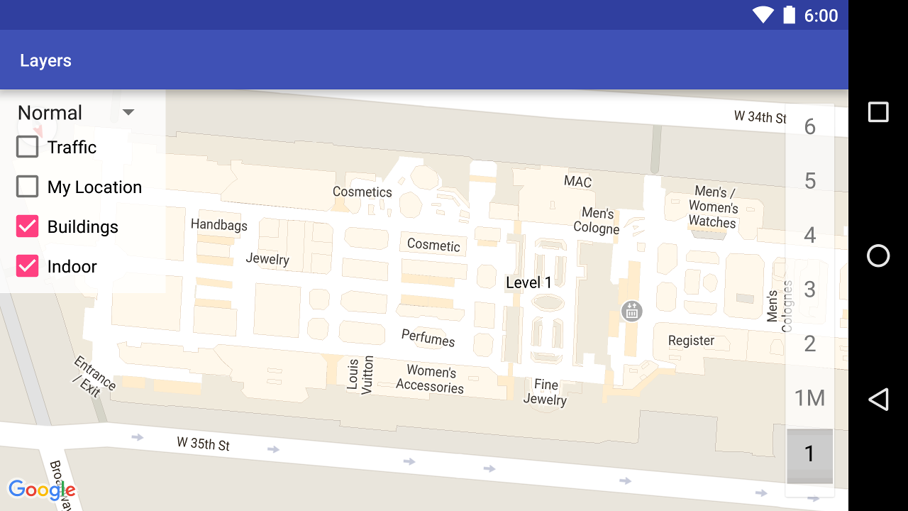
At high zoom levels, the map shows floor plans for
indoor spaces such as airports, shopping malls, large retail stores, and transit
stations. These floor plans, called indoor maps, are displayed for the 'normal'
and 'satellite' [map types](https://developers.google.com/maps/documentation/android-sdk/configure-map.md.txt#maptype) (`GoogleMap.MAP_TYPE_NORMAL` and
`GoogleMap.MAP_TYPE_SATELLITE`). They are automatically enabled when the user
zooms in, and they fade away when the map is zoomed out.
**Deprecation notice:** In a future release, indoor
maps will only be available on the `normal` map type. From that
future release, indoor maps will not be supported on `satellite`,
`terrain` or `hybrid` maps. Even where indoor is not
supported, `isIndoorEnabled()` will continue to return the value
that has been set using `setIndoorEnabled()`, as it does now. By
default, `setIndoorEnabled` is `true`. The
[release notes](https://developers.google.com/maps/documentation/android-sdk/releases) will let
you know when indoor support becomes unavailable on those map types.
Here is a summary of the indoor maps capabilities in the API:
- You can disable indoor maps by calling [`GoogleMap.setIndoorEnabled(false)`](https://developers.google.com/maps/documentation/android-sdk/reference/com/google/android/libraries/maps/GoogleMap.md.txt#public-boolean-setindoorenabled-boolean-enabled). By default, indoor maps are enabled. Indoor maps are displayed on one map at a time. By default this is the first map added to your app. To display indoor maps on a different map, disable them on the first map, then call `setIndoorEnabled(true)` on the second map.
- To disable the default level picker (floor picker), call [`GoogleMap.getUiSettings().setIndoorLevelPickerEnabled(false)`](https://developers.google.com/maps/documentation/android-sdk/reference/com/google/android/libraries/maps/UiSettings.md.txt#public-void-setindoorlevelpickerenabled-boolean-enabled). For more details, see [Interacting with the Map](https://developers.google.com/maps/documentation/android-sdk/controls.md.txt#level_picker).
- [`OnIndoorStateChangeListener`](https://developers.google.com/maps/documentation/android-sdk/reference/com/google/android/libraries/maps/GoogleMap.md.txt#public-void-setonindoorstatechangelistener-googlemap.onindoorstatechangelistener-listener) --- defines listeners that that detect when a building comes into focus, or a level is activated in a building. For details, see [Interacting with the Map](https://developers.google.com/maps/documentation/android-sdk/events.md.txt#indoor_map_events).
- [`getFocusedBuilding`](https://developers.google.com/maps/documentation/android-sdk/reference/com/google/android/libraries/maps/GoogleMap.md.txt#public-indoorbuilding-getfocusedbuilding) --- retrieves the building that is in focus. You can then find the active level by calling `IndoorBuilding.getActiveLevelIndex()`.
- [Styling the base map](https://developers.google.com/maps/documentation/android-sdk/styling.md.txt) does not affect indoor maps.
## Set up map padding
This video shows an example of map padding.
[Video](https://www.youtube.com/watch?v=HSCsdiqNjGo)
A Google map is designed to fill the entire region defined by its container
element, typically a `MapView` or `SupportMapFragment`. Several aspects of how
the map appears and behaves are defined by the dimensions of its container:
- The camera's target will reflect the center of the padded region.
- [Map controls](https://developers.google.com/maps/documentation/android-sdk/controls.md.txt) are positioned relative to the edges of the map.
- Legal information, such as copyright statements or the Google logo appear along the bottom edge of the map.
You can add padding around the edges of the map using the
`GoogleMap`.[`setPadding()`](https://developers.google.com/maps/documentation/android-sdk/reference/com/google/android/libraries/maps/GoogleMap.md.txt#public-void-setpadding-int-left,-int-top,-int-right,-int-bottom) method. The map will
continue to fill the entire container, but text and control positioning, map
gestures, and camera movements will behave as if it has been placed in a
smaller space. This results in the following changes:
- Camera movements using API calls or button presses (e.g., compass, my location, zoom buttons) are relative to the padded region.
- The `getCameraPosition` method returns the center of the padded region.
- The `Projection` and `getVisibleRegion` methods return the padded region.
- UI controls are offset from the edge of the container by the specified number of pixels.
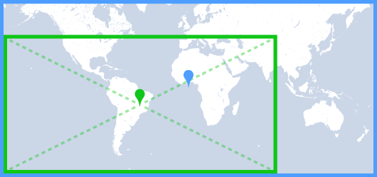
Padding can be helpful when designing UIs that overlap some portion of the
map. In the following image, the map is padded along the top and
right edges. Visible map controls and legal text will be displayed along the
edges of the padded region, shown in green, while the map will continue to
fill the entire container, shown in blue. In this example, you could float a
menu over the right side of the map without obscuring map controls.
> [!NOTE]
> **Note:** As per the [Google Maps Platform Terms of Service](https://cloud.google.com/maps-platform/terms), your application must not remove or obscure the Google logo or copyright notices. Map padding lets you reposition these elements if necessary. If you display a custom UI at the bottom of the map, add padding to the bottom of the map so that the logo and legal notices will always be visible.
## Map color scheme
For maps of type normal and terrain, you can set the map color scheme
dynamically to dark, light, or to use the current system setting. For example,
you can darken or lighten the map color scheme based on the time of day or
indoor or outdoor use of the device.
Starting with version 20.1.0 of the Maps SDK for Android, the map follows the
current system setting by default. In earlier versions, the map uses light
mode by default. The current system setting value is based on the device
setting for `UI_NIGHT_MODE_MASK`.
### Kotlin
```kotlin
mapFragment = SupportMapFragment.newInstance(GoogleMapOptions().mapColorScheme(MapColorScheme.DARK).mapId(mapId2))
```
### Java
```java
mapFragment = SupportMapFragment.newInstance(new GoogleMapOptions().mapColorScheme(MapColorScheme.DARK).mapId(mapId2));
```
You can toggle the color scheme using the
[`GoogleMap.setMapColorScheme()`](https://developers.google.com/android/reference/com/google/android/gms/maps/GoogleMap.md.txt)
method to set the current style to dark mode, light mode, or follow the system
settings.
### Kotlin
```kotlin
googleMap.setMapColorScheme(MapColorScheme.DARK)
googleMap.setMapColorScheme(MapColorScheme.LIGHT)
googleMap.setMapColorScheme(MapColorScheme.FOLLOW_SYSTEM)
```
### Java
```java
googleMap.setMapColorScheme(MapColorScheme.DARK);
googleMap.setMapColorScheme(MapColorScheme.LIGHT);
googleMap.setMapColorScheme(MapColorScheme.FOLLOW_SYSTEM);
```
To create custom light styles and dark styles for your maps, use
[cloud-based maps styling](https://developers.google.com/maps/documentation/android-sdk/cloud-customization.md.txt).
> [!NOTE]
> **Note:** Dark mode color scheme will only take effect on maps that don't use custom styling, or on maps that use cloud-based maps styling. Maps with JSON styling or maps using [lite mode](https://developers.google.com/maps/documentation/android-sdk/lite.md.txt) won't show the dark mode color scheme.
### Configure background color
When working in dark mode or switching between map views, it may be useful to
configure the default map background color. This can be achieved by setting the
map options `backgroundColor` property.
### Kotlin
```kotlin
private val googleMapOptions: GoogleMapOptions =
GoogleMapOptions().backgroundColor(Color.argb(255, 255, 0, 0));
```
### Java
```java
private GoogleMapOptions options = new GoogleMapOptions().backgroundColor(Color.argb(255, 255, 0, 0));
```
> [!NOTE]
> **Note:** Background color does not support opacity values.
You can also use cloud-based maps styling to configure the
background color. The background color set in
maps styling has a higher priority than the local
background color. For more information, see [Change the app background
color](https://developers.google.com/maps/documentation/android-sdk/cloud-customization/app-background-leg) for
cloud-based maps styling.