Select platform: [Android](https://developers.google.com/maps/documentation/android-sdk/coordinates.md.txt "View this page for the Android platform docs.") [iOS](https://developers.google.com/maps/documentation/ios-sdk/coordinates.md.txt "View this page for the iOS platform docs.") [JavaScript](https://developers.google.com/maps/documentation/javascript/coordinates.md.txt "View this page for the JavaScript platform docs.")
The Maps SDK for Android uses the following coordinate systems:
- Latitude and longitude values, which reference a point on the world uniquely. Google uses the [World Geodetic System WGS84](https://en.wikipedia.org/wiki/World_Geodetic_System) standard.
- World coordinates, which reference a point on the map uniquely.
- Pixel coordinates, which reference a specific pixel on the map at a specific zoom level.
- Tile coordinates, which reference a specific tile on the map at a specific zoom level.
## World coordinates
Whenever the API needs to translate a location in the world to a location on
a map, it first translates latitude and longitude values into a
*world* coordinate. The API uses the
[Mercator
projection](https://en.wikipedia.org/wiki/Mercator_projection) to perform this translation.
For convenience in the calculation of pixel coordinates (see below)
we assume a map at zoom level 0 is a single tile of the base tile size.
We then define world coordinates relative to pixel coordinates at zoom
level 0, using the projection to convert latitudes and longitudes to
pixel positions on this base tile. This world coordinate is a floating
point value measured from the origin of the map projection to the
specific location. Note that since this value is a floating point value,
it may be much more precise than the current resolution of the map image
being shown. A world coordinate is independent of the current zoom level,
in other words.
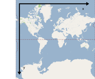
World coordinates in Google Maps are measured from the Mercator
projection's origin (the northwest corner of the map at 180 degrees
longitude and approximately 85 degrees latitude) and increase in
the `x` direction towards the east (right) and increase in
the `y` direction towards the south (down). Because the
basic Mercator Google Maps tile is 256 x 256 pixels, the usable
world coordinate space is `{0-256}, {0-256}`.
Note that a Mercator projection has a finite
width longitudinally but an infinite height latitudinally. We cut off
base map imagery utilizing the Mercator projection at approximately
+/- 85 degrees to make the resulting map shape square, which allows
easier logic for tile selection. Note that a projection may produce
world coordinates outside the base map's usable coordinate space
if you plot very near the poles, for example.
## Pixel coordinates
*Pixel coordinates* reference a specific pixel on the map at a
specific zoom level, whereas world coordinates reflect absolute locations on a
given projection. Pixel coordinates are calculated using the following
formula:
```
pixelCoordinate = worldCoordinate * 2zoomLevel
```
From the above equation, note that each increasing zoom level
is twice as large in both the `x` and `y`
directions. Therefore, each higher zoom level results in a resolution four
times higher than the preceding level. For example, at zoom level 1,
the map consists of 4 256x256 pixels tiles, resulting in a pixel space
from 512x512. At zoom level 19, each `x` and `y` pixel
on the map can be referenced using a value between
0 and 256 \* 2^19^.
Because we based world coordinates on the map's tile size, a
pixel coordinate's integer part has the effect of identifying the exact pixel
at that location in the current zoom level. Note that for zoom level 0, the
pixel coordinates are equal to the world coordinates.
These coordinate systems accurately denote each location on the map, at each
zoom level. The Maps SDK for Android constructs a viewport given the zoom level,
the center of the map as a `LatLng`, and the size of the containing DOM element,
and translates this bounding box into pixel coordinates. The API then logically
determines all map tiles that lie within the given pixel bounds. You reference
each of these map tiles by using [tile coordinates](https://developers.google.com/maps/documentation/android-sdk/coordinates.md.txt#tile-coordinates), which
greatly simplify the display of map imagery.
## Tile coordinates
The API can't load all the map imagery at once for higher zoom levels. Instead,
it breaks up the imagery at each zoom level into a set of map tiles, which
are logically arranged in an order that your application can use. When a
map scrolls to a new location or a new zoom level, the API determines which
tiles it needs by using pixel coordinates, and then translates those values into
a set of tiles to retrieve. It assigns these tile coordinates using a scheme
that makes it straightforward to determine which tile contains the imagery for
any given point.
Tiles in Google Maps are numbered from the same origin as that
for pixels. For Google's implementation of the Mercator projection, the
origin tile is always at the northwest corner
of the map, with `x` values increasing from west to
east and `y` values increasing from north to south. Tiles
are indexed using `x,y` coordinates from that origin. For
example, at zoom level 2, when the earth is divided up into 16 tiles,
each tile can be referenced by a unique `x,y` pair:
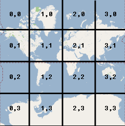
Note that by dividing the pixel coordinates by the tile size (256) and
taking the integer parts of the result, you produce as a by-product
the tile coordinate at the current zoom level.
## Example
The following example displays coordinates for Chicago, IL:
latitude/longitude values, world coordinates, pixel coordinates, and tile
coordinates. Use the zoom control to see the coordinate values at various
zoom levels.
To see how the coordinates were calculated,
[view
the code](https://developers.google.com/maps/documentation/javascript/examples/map-coordinates).