Select platform: [Android](https://developers.google.com/maps/documentation/android-sdk/dds-boundaries/choropleth-map.md.txt "View this page for the Android platform docs.") [iOS](https://developers.google.com/maps/documentation/ios-sdk/dds-boundaries/choropleth-map.md.txt "View this page for the iOS platform docs.") [JavaScript](https://developers.google.com/maps/documentation/javascript/dds-boundaries/choropleth-map.md.txt "View this page for the JavaScript platform docs.")
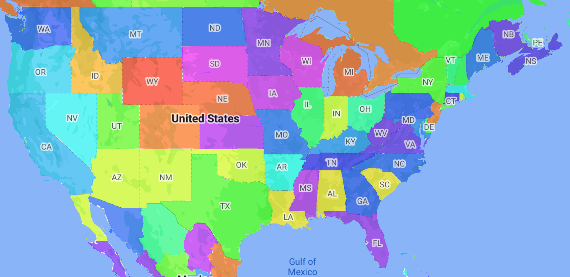
A choropleth map is a type of thematic map in which administrative areas are
colored or shaded according to a data value. You can use a style factory
function to style a map based on data where each administrative area is
associated with a range of numeric values. The following example map shows a
choropleth map for the states of the United States.
In this example, the data consists of the place ID of the state. The style
factory function conditionally colors each state based on a hashed value of the
place ID for the state.
> [!NOTE]
> **Note:** Typically, you would define a table of the color for each state, and then lookup the color for each state based on the state's place ID.
1. If you haven't already done so, follow the steps in
[Get Started](https://developers.google.com/maps/documentation/android/dds-boundaries/start)
to create a new map ID and map style. Be sure to enable the
**Administrative Area Level 1** feature layer.
2. Get a reference to the Administrative Area Level 1 feature layer when the
map initializes. For the United States, these administrative levels
correspond to the individual states.
### Java
```java
private FeatureLayer areaLevel1Layer;
@Override
public void onMapReady(GoogleMap map) {
areaLevel1Layer = map.getFeatureLayer(new FeatureLayerOptions.Builder()
.featureType(FeatureType.ADMINISTRATIVE_AREA_LEVEL_1)
.build());
// Apply style factory function to ADMINISTRATIVE_AREA_LEVEL_1 layer.
styleAreaLevel1Layer();
}
```
### Kotlin
```java
private var areaLevel1Layer: FeatureLayer? = null
override fun onMapReady(googleMap: GoogleMap) {
// Get the ADMINISTRATIVE_AREA_LEVEL_1 feature layer.
areaLevel1Layer = googleMap.getFeatureLayer(FeatureLayerOptions.Builder()
.featureType(FeatureType.ADMINISTRATIVE_AREA_LEVEL_1)
.build())
// Apply style factory function to ADMINISTRATIVE_AREA_LEVEL_1 layer.
styleAreaLevel1Layer()
}
```
3. Create a style factory function and apply it to the
Administrative Area Level 1 feature layer. The following example applies the
function to the polygon representing each state of the United States.
### Java
```java
private void styleAreaLevel1Layer() {
FeatureLayer.StyleFactory styleFactory = (Feature feature) -> {
if (feature instanceof PlaceFeature) {
PlaceFeature placeFeature = (PlaceFeature) feature;
// Return a hueColor in the range [-299,299]. If the value is
// negative, add 300 to make the value positive.
int hueColor = placeFeature.getPlaceId().hashCode() % 300;
if (hueColor < 0) {
hueColor += 300;
}
return new FeatureStyle.Builder()
// Set the fill color for the state based on the hashed hue color.
.fillColor(Color.HSVToColor(150, new float[] {hueColor, 1, 1}))
.build();
}
return null;
};
// Apply the style factory function to the feature layer.
areaLevel1Layer.setFeatureStyle(styleFactory);
}
```
### Kotlin
```java
private fun styleAreaLevel1Layer() {
val styleFactory = FeatureLayer.StyleFactory { feature: Feature ->
if (feature is PlaceFeature) {
val placeFeature: PlaceFeature = feature as PlaceFeature
// Return a hueColor in the range [-299,299]. If the value is
// negative, add 300 to make the value positive.
var hueColor: Int = placeFeature.getPlaceId().hashCode() % 300
if (hueColor < 0) {
hueColor += 300
}
return@StyleFactory FeatureStyle.Builder()
// Set the fill color for the state based on the hashed hue color.
.fillColor(Color.HSVToColor(150, floatArrayOf(hueColor.toFloat(), 1f, 1f)))
.build()
}
return@StyleFactory null
}
// Apply the style factory function to the feature layer.
areaLevel1Layer?.setFeatureStyle(styleFactory)
}
```