Select platform: [Android](https://developers.google.com/maps/documentation/android-sdk/views.md.txt "View this page for the Android platform docs.") [iOS](https://developers.google.com/maps/documentation/ios-sdk/views.md.txt "View this page for the iOS platform docs.") [JavaScript](https://developers.google.com/maps/documentation/javascript/vector-map.md.txt "View this page for the JavaScript platform docs.")
The maps in the Maps SDK for Android can be tilted and rotated with easy
gestures, giving users the ability to adjust the map with an orientation that
makes sense for them. At any zoom level, you can pan the map, or change its
perspective with very little latency thanks to the smaller footprint of the
vector-based map tiles.
## Code samples
The [ApiDemos repository](https://github.com/googlemaps-samples/android-samples/blob/main/ApiDemos) on GitHub includes a sample that
demonstrates the camera features:
- [CameraDemoActivity - Kotlin](https://github.com/googlemaps-samples/android-samples/blob/main/ApiDemos/project/kotlin-app/src/main/java/com/example/kotlindemos/CameraDemoActivity.kt): Changing the camera position
- [CameraDemoActivity - Java](https://github.com/googlemaps-samples/android-samples/blob/main/ApiDemos/project/java-app/src/main/java/com/example/mapdemo/CameraDemoActivity.java): Changing the camera position
## Introduction
Like Google Maps on the web, the Maps SDK for Android represents the
world's surface (a sphere) on your device's screen (a flat plane) using the
[Mercator projection](https://en.wikipedia.org/wiki/Mercator_projection). In the east and west direction, the map
is repeated infinitely as the world seamlessly wraps around on itself. In the
north and south direction the map is limited to approximately 85 degrees north
and 85 degrees south.
**Note:** A Mercator projection has a finite width
longitudinally but an infinite height latitudinally. We "cut off" base map
imagery utilizing the Mercator projection at approximately +/- 85 degrees to
make the resulting map shape square, which allows easier logic for tile
selection.
The Maps SDK for Android allows you to change the user's viewpoint of the
map by modifying the map's **camera**.
[Video](https://www.youtube.com/watch?v=gkze68UlHdk)
Changes to the camera will not make any changes to markers, overlays, or other
graphics you've added, although you may want to change your additions to fit
better with the new view.
Because you can listen for user gestures on the map, you can change the map in
response to user requests. For example, the callback method
[`OnMapClickListener.onMapClick()`](https://developers.google.com/android/reference/com/google/android/gms/maps/GoogleMap.OnMapClickListener.md.txt#onMapClick(com.google.android.gms.maps.model.LatLng)) responds to a
single tap on the map. Because the method receives the latitude and longitude
of the tap location, you can respond by panning or zooming to that point.
Similar methods are available for responding to taps on a marker's bubble or
for responding to a drag gesture on a marker.
You can also listen for camera movements, so that your app receives a
notification when the camera starts moving, is currently moving, or stops
moving. For details, see the guide to [camera change events](https://developers.google.com/maps/documentation/android-sdk/events.md.txt#camera_change_events).
## The camera position
The map view is modeled as a **camera** looking down on a flat plane. The position
of the camera (and hence the rendering of the map) is specified by the
following properties: [target (latitude/longitude location)](https://developers.google.com/maps/documentation/android-sdk/views.md.txt#target_location),
[bearing](https://developers.google.com/maps/documentation/android-sdk/views.md.txt#bearing_orientation), [tilt](https://developers.google.com/maps/documentation/android-sdk/views.md.txt#tilt_viewing_angle),
and [zoom](https://developers.google.com/maps/documentation/android-sdk/views.md.txt#zoom).
:camera:
### Target (location)
The camera target is the location of the center of the map, specified as
latitude and longitude coordinates.
The latitude can be between -85 and 85 degrees, inclusive. Values above or below this range will be clamped to the nearest value within this range. For example, specifying a latitude of 100 will set the value to 85. Longitude ranges between -180 and 180 degrees, inclusive. Values above or below this range will be wrapped such that they fall within the range (-180, 180). For example, 480, 840 and 1200 will all be wrapped to 120 degrees.
### Bearing (orientation)
The camera bearing specifies the compass direction, measured in degrees from true north, corresponding
to the top edge of the map. If you draw a vertical line from the center of the map to the top edge
of the map, the bearing corresponds to the heading of the camera (measured in degrees) relative
to true north.
A bearing of 0 means that the top of the map points to true north.
A bearing value 90 means the top of the map points due east (90 degrees on a compass). A value
180 means the top of the map points due south.
The Maps API lets you change a map's bearing. For example, someone driving a car
often turns a road map to align it with their direction of travel, while hikers using a map and
compass usually orient the map so that a vertical line is pointing north.
### Tilt (viewing angle)
The tilt defines the camera's position on an arc directly over the map's
center position, measured in degrees from the
[nadir](https://en.wikipedia.org/wiki/Nadir)
(the direction pointing directly below the camera). A value of 0 corresponds to a camera pointed
straight down. Values greater than 0 correspond to a camera that is pitched toward the horizon by
the specified number of degrees.
When you change the viewing angle, the map appears in perspective, with far-away features
appearing smaller, and nearby features appearing larger. The following
illustrations demonstrate this.
In the images below, the viewing angle is 0 degrees. The first image shows a
schematic of this; position **1** is the camera position, and position **2**
is the current map position. The resulting map is shown below it.
|---|---|
|  The map displayed with the camera's default viewing angle. |  The default viewing angle of the camera. |
In the images below, the viewing angle is 45 degrees. Notice that the camera
moves halfway along an arc between straight overhead (0 degrees) and the ground (90 degrees),
to position **3** . The camera is still pointing at the map's center point, but the area
represented by the line at position **4** is now visible.
|---|---|
|  The map displayed with a viewing angle of 45 degrees. | 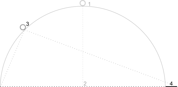 A camera viewing angle of 45 degrees. |
The map in this screenshot is still centered on the same point as in the
original map, but more features have appeared at the top of the map. As you
increase the angle beyond 45 degrees, features between the camera and the map
position appear proportionally larger, while features beyond the map position
appear proportionally smaller, yielding a three-dimensional effect.
### Zoom
The zoom level of the camera determines the scale of the map. At larger zoom
levels more detail can be seen on the screen, while at smaller zoom levels
more of the world can be seen on the screen.
At zoom level 0, the scale of the
map is such that the entire world has a width of approximately 256dp
([density-independent pixels](https://developer.android.com/guide/topics/resources/more-resources.html#Dimension)).
Increasing the zoom level by 1 doubles the width of the world on the screen.
Hence at zoom level N, the width of the world is approximately
256 \* 2^N^ dp. For example, at zoom level 2, the whole world is approximately
1024dp wide.
The zoom level need not be an integer. The range of zoom
levels permitted by the map depends on a number of factors including target,
map type and screen size. Any number out of the range will be converted to the
next closest valid value, which can be either the minimum zoom level or the
maximum zoom level. The following list shows the approximate level of detail
you can expect to see at each zoom level:
- 1: World
- 5: Landmass/continent
- 10: City
- 15: Streets
- 20: Buildings
> [!NOTE]
> **Note:** Due to screen size and density, some devices may not support the lowest zoom levels. Use [`GoogleMap.getMinimumZoomLevel()`](https://developers.google.com/android/reference/com/google/android/gms/maps/GoogleMap.md.txt#getMinZoomLevel()) to get the minimum zoom level possible for the map. If you need to show the entire world in the viewport, it may be better to use [Lite Mode](https://developers.google.com/maps/documentation/android-sdk/lite.md.txt).
The following images show the visual appearance of different zoom levels:
|---|---|---|
|  A map at zoom level 5. | 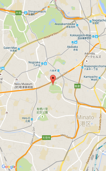 A map at zoom level 15. |  A map at zoom level 20. |
## Moving the camera
The Maps API allows you to change which part of the world is visible on the
map. This is achieved by changing the position of the camera (as opposed to
moving the map).
When you change the camera, you have the option of animating the resulting
camera movement. The animation interpolates between the current camera
attributes and the new camera attributes. You can also control the
duration of the animation.
> [!NOTE]
> **Note:** All programmatic camera movements are calculated against size of the `GoogleMap` object after first taking into account any padding that has been added to the map. For example, adding 100 pixels of padding to the left edge of your map will shift the center of your map to the right by 50 pixels. More information is available in the [map padding](https://developers.google.com/maps/documentation/android-sdk/map.md.txt#map_padding) documentation.
To change the position of the camera, you must specify where you want to
move the camera, using a [`CameraUpdate`](https://developers.google.com/android/reference/com/google/android/gms/maps/CameraUpdate.md.txt). The Maps API
allows you to create many different types of `CameraUpdate` using
`CameraUpdateFactory`. The following options are available:
### Changing zoom level and setting minimum/maximum zoom
[`CameraUpdateFactory.zoomIn()`](https://developers.google.com/android/reference/com/google/android/gms/maps/CameraUpdateFactory.md.txt#zoomIn()) and
[`CameraUpdateFactory.zoomOut()`](https://developers.google.com/android/reference/com/google/android/gms/maps/CameraUpdateFactory.md.txt#zoomOut())
give you a `CameraUpdate` that changes the zoom level by 1.0, while keeping
all other properties the same.
[`CameraUpdateFactory.zoomTo(float)`](https://developers.google.com/android/reference/com/google/android/gms/maps/CameraUpdateFactory.md.txt#zoomTo(float))
gives you a `CameraUpdate` that changes the zoom level to the given value,
while keeping all other properties the same.
[`CameraUpdateFactory.zoomBy(float)`](https://developers.google.com/android/reference/com/google/android/gms/maps/CameraUpdateFactory.md.txt#zoomBy(float))
and
[`CameraUpdateFactory.zoomBy(float, Point)`](https://developers.google.com/android/reference/com/google/android/gms/maps/CameraUpdateFactory.md.txt#zoomBy(float,%20android.graphics.Point))
give you a `CameraUpdate` that increases (or decreases, if the value is
negative) the zoom level by the given value. The latter fixes the given point
on the screen such that it remains at the same location (latitude/longitude)
and so it may change the location of the camera in order to achieve this.
You may find it useful to set a preferred minimum and/or maximum zoom level.
For example, this is useful to control the user's experience if your app shows a
defined area around a point of interest, or if you're using a custom tile
overlay with a limited set of zoom levels.
### Kotlin
```kotlin
map.setMinZoomPreference(6.0f)
map.setMaxZoomPreference(14.0f)
```
### Java
```java
map.setMinZoomPreference(6.0f);
map.setMaxZoomPreference(14.0f);
```
Note that there are technical considerations that may prevent the API from
allowing users to zoom too low or too high. For example, satellite or terrain
may have a lower maximum zoom than the base map tiles.
### Changing camera position
There are two convenience methods for the common position changes.
[`CameraUpdateFactory.newLatLng(LatLng)`](https://developers.google.com/android/reference/com/google/android/gms/maps/CameraUpdateFactory.md.txt#newLatLng(com.google.android.gms.maps.model.LatLng))
gives you a `CameraUpdate` that changes the camera's latitude and longitude,
while preserving all other properties.
[`CameraUpdateFactory.newLatLngZoom(LatLng, float)`](https://developers.google.com/android/reference/com/google/android/gms/maps/CameraUpdateFactory.md.txt#newLatLngZoom(com.google.android.gms.maps.model.LatLng,%20float))
gives you a [`CameraUpdate`](https://developers.google.com/android/reference/com/google/android/gms/maps/CameraUpdate.md.txt) that changes the camera's
latitude, longitude and zoom, while preserving all other properties.
For full flexibility in changing the camera position, use
[`CameraUpdateFactory.newCameraPosition(CameraPosition)`](https://developers.google.com/android/reference/com/google/android/gms/maps/CameraUpdateFactory.md.txt#newCameraPosition(com.google.android.gms.maps.model.CameraPosition))
which gives you a [`CameraUpdate`](https://developers.google.com/android/reference/com/google/android/gms/maps/CameraUpdate.md.txt) that moves the camera to
the given position. A `CameraPosition` can be obtained either directly, using
`new CameraPosition()` or with a `CameraPosition.Builder` using
`new CameraPosition.Builder()`.
### Panning (scrolling)
`CameraUpdateFactory.scrollBy(float, float)` gives you a `CameraUpdate` that
changes the camera's latitude and longitude such that the map moves by the
specified number of pixels. A positive x value causes the camera to move to
the right, so that the map appears to have moved to the left. A positive y
value causes the camera to move down, so that the map appears to have moved
up. Conversely, negative x values cause the camera to move to the left, so
that the map appears to have moved right and negative y values cause the
camera to move up. The scrolling is relative to the camera's current
orientation. For example, if the camera has a bearing of 90 degrees, then east
is "up".
## Setting boundaries
### Setting the bounds of the map
It's sometimes useful to move the
camera such that an entire area of interest is visible at the greatest possible
zoom level. For example, if you're displaying all of the gas stations within
five miles of the user's current position, you may want to move the camera such
that they are all visible on the screen. To do this, first calculate the
[`LatLngBounds`](https://developers.google.com/android/reference/com/google/android/gms/maps/model/LatLngBounds.md.txt) that you want to be visible on the screen. You
can then use `CameraUpdateFactory.newLatLngBounds(LatLngBounds bounds, int
padding)` to obtain a [`CameraUpdate`](https://developers.google.com/android/reference/com/google/android/gms/maps/CameraUpdate) that changes the camera
position such that the given `LatLngBounds` fits entirely within the map, taking
into account the padding (in pixels) specified. The returned `CameraUpdate`
ensures that the gap (in pixels) between the given bounds and the edge of the
map will be at least as much as the specified padding. Note that the tilt and
bearing of the map will both be 0.
### Kotlin
```kotlin
val australiaBounds = LatLngBounds(
LatLng((-44.0), 113.0), // SW bounds
LatLng((-10.0), 154.0), // NE bounds
)
map.moveCamera(CameraUpdateFactory.newLatLngBounds(australiaBounds, 0))
```
### Java
```java
LatLngBounds australiaBounds =
new LatLngBounds(
new LatLng(-44, 113), // SW bounds
new LatLng(-10, 154) // NE bounds
);
map.moveCamera(CameraUpdateFactory.newLatLngBounds(australiaBounds, 0));
```
> [!NOTE]
> **Note:** You can only invoke `newLatLngBounds(boundary, padding)` to change the camera after the map layout is complete. This is because the API calculates the display boundaries of the map during layout. If you want to call `newLatLngBounds()` before layout has occurred, you can use `newLatLngBounds(boundary, width, height, padding)` described [below](https://developers.google.com/maps/documentation/android-sdk/views.md.txt#center-map).
### Centering the map within an area
In some cases, you may wish to center your camera within a bounds instead of
including the extreme borders. For example, to center the camera on a country
while maintaining a constant zoom. In this case, you can use a similar method,
by creating a [`LatLngBounds`](https://developers.google.com/android/reference/com/google/android/gms/maps/model/LatLngBounds.md.txt) and using
`CameraUpdateFactory.newLatLngZoom(LatLng latLng, float zoom)` with the
`LatLngBounds`.`getCenter()` method. The getCenter() method will return the
geographic center of the `LatLngBounds`.
### Kotlin
```kotlin
val australiaBounds = LatLngBounds(
LatLng((-44.0), 113.0), // SW bounds
LatLng((-10.0), 154.0), // NE bounds
)
map.moveCamera(CameraUpdateFactory.newLatLngZoom(australiaBounds.center, 10f))
```
### Java
```java
LatLngBounds australiaBounds =
new LatLngBounds(
new LatLng(-44, 113), // SW bounds
new LatLng(-10, 154) // NE bounds
);
map.moveCamera(CameraUpdateFactory.newLatLngZoom(australiaBounds.getCenter(), 10));
```
An overload of the method, [`newLatLngBounds(boundary, width, height,
padding)`](https://developers.google.com/android/reference/com/google/android/gms/maps/CameraUpdate)
allows you to specify a width and height in pixels for a
rectangle, with the intention that these correspond to the dimensions of the
map. The rectangle is positioned such that its center is the same as that of
the map's view (so that if the dimensions specified are the same as those of
the map's view, then the rectangle coincides with the map's view). The
returned `CameraUpdate` will move the camera such that the specified
`LatLngBounds` are centered on screen within the given rectangle at the
greatest possible zoom level, taking into account the padding required.
**Note:** Only use the simpler method
`newLatLngBounds(boundary, padding)`
to generate a `CameraUpdate` if it is going to be used to move
the camera after the map has undergone layout. During layout, the API
calculates the display boundaries of the map which are needed to correctly
project the bounding box. In comparison, you can use the
`CameraUpdate` returned by the more complex method
`newLatLngBounds(boundary, width, height, padding)`
at any time, even before the map has undergone layout, because the API
calculates the display boundaries from the arguments that you pass.
### Restricting the user's panning to a given area
In the above scenarios, you set the bounds of the map but the user
can then scroll or pan outside of these bounds. Instead, you may want to
constrain the lat/lng centre bounds of the focal point of the map (the camera
target) so that users can only scroll and pan within these bounds. For example,
a retail app for a shopping centre or airport may want to constrain the map to a
particular bounds, allowing users to scroll and pan within those bounds.
### Kotlin
```kotlin
// Create a LatLngBounds that includes the city of Adelaide in Australia.
val adelaideBounds = LatLngBounds(
LatLng(-35.0, 138.58), // SW bounds
LatLng(-34.9, 138.61), // NE bounds
)
// Constrain the camera target to the Adelaide bounds.
map.setLatLngBoundsForCameraTarget(adelaideBounds)
```
### Java
```java
// Create a LatLngBounds that includes the city of Adelaide in Australia.
LatLngBounds adelaideBounds =
new LatLngBounds(
new LatLng(-35.0, 138.58), // SW bounds
new LatLng(-34.9, 138.61) // NE bounds
);
// Constrain the camera target to the Adelaide bounds.
map.setLatLngBoundsForCameraTarget(adelaideBounds);
```
The following diagram illustrates a scenario when the camera target is
constrained to an area that is slightly larger than the viewport. The user can
scroll and pan, provided the camera target remains within the bounded area. The
cross represents the camera target:

The map always fills the viewport, even if that results in the viewport showing
areas that are outside the defined bounds. For example, if you position the
camera target at a corner of the bounded area, the area beyond the corner is
visible in the viewport but users cannot scroll further into that area. The
following diagram illustrates this scenario. The cross represents the camera
target:

In the following diagram, the camera target has a very restricted bounds,
offering the user very little opportunity to scroll or pan the map. The cross
represents the camera target:

## Updating the camera view
To apply a [`CameraUpdate`](https://developers.google.com/android/reference/com/google/android/gms/maps/CameraUpdate.md.txt) to the map, you can either move
the camera instantly or animate the camera smoothly. To move the camera
instantly with the given `CameraUpdate`, you can call
`GoogleMap.moveCamera(CameraUpdate)`.
You can make the user experience more pleasing, especially for short moves,
by animating the change. To do this instead of calling
[`GoogleMap.moveCamera`](https://developers.google.com/android/reference/com/google/android/gms/maps/GoogleMap.md.txt#moveCamera(com.google.android.gms.maps.CameraUpdate))
call
[`GoogleMap.animateCamera`](https://developers.google.com/android/reference/com/google/android/gms/maps/GoogleMap.md.txt#animateCamera(com.google.android.gms.maps.CameraUpdate)).
The map will move smoothly to the new attributes. The most detailed form of this method,
[`GoogleMap.animateCamera(cameraUpdate, duration, callback)`](https://developers.google.com/android/reference/com/google/android/gms/maps/GoogleMap.md.txt#animateCamera(com.google.android.gms.maps.CameraUpdate,%20int,%20com.google.android.gms.maps.GoogleMap.CancelableCallback)),
offers three arguments:
`cameraUpdate`
: The [`CameraUpdate`](https://developers.google.com/android/reference/com/google/android/gms/maps/CameraUpdate.md.txt)
describing where to move the camera.
`callback`
: An object that implements
[`GoogleMap.CancellableCallback`](https://developers.google.com/android/reference/com/google/android/gms/maps/GoogleMap.CancelableCallback.md.txt).
This generalized interface for handling tasks defines two methods
\`onCancel()\` and \`onFinished()\`. For animation, the methods are called in
the following circumstances:
[`onFinish()`](https://developers.google.com/android/reference/com/google/android/gms/maps/GoogleMap.CancelableCallback.md.txt#onFinish())
: Invoked if the animation goes to completion without interruption.
[`onCancel()`](https://developers.google.com/android/reference/com/google/android/gms/maps/GoogleMap.CancelableCallback.md.txt#onCancel())
: Invoked if the animation is interrupted by calling
`stopAnimation()` or starting a new camera movement.
Alternatively, this can also occur if you call
[`GoogleMap.stopAnimation()`](https://developers.google.com/android/reference/com/google/android/gms/maps/GoogleMap.md.txt#stopAnimation()).
`duration`
: Desired duration of the animation, in milliseconds, as an `int`.
The following code snippets illustrate some of the common ways to move the
camera.
### Kotlin
```kotlin
val sydney = LatLng(-33.88, 151.21)
val mountainView = LatLng(37.4, -122.1)
// Move the camera instantly to Sydney with a zoom of 15.
map.moveCamera(CameraUpdateFactory.newLatLngZoom(sydney, 15f))
// Zoom in, animating the camera.
map.animateCamera(CameraUpdateFactory.zoomIn())
// Zoom out to zoom level 10, animating with a duration of 2 seconds.
map.animateCamera(CameraUpdateFactory.zoomTo(10f), 2000, null)
// Construct a CameraPosition focusing on Mountain View and animate the camera to that position.
val cameraPosition = CameraPosition.Builder()
.target(mountainView) // Sets the center of the map to Mountain View
.zoom(17f) // Sets the zoom
.bearing(90f) // Sets the orientation of the camera to east
.tilt(30f) // Sets the tilt of the camera to 30 degrees
.build() // Creates a CameraPosition from the builder
map.animateCamera(CameraUpdateFactory.newCameraPosition(cameraPosition))
```
### Java
```java
LatLng sydney = new LatLng(-33.88, 151.21);
LatLng mountainView = new LatLng(37.4, -122.1);
// Move the camera instantly to Sydney with a zoom of 15.
map.moveCamera(CameraUpdateFactory.newLatLngZoom(sydney, 15));
// Zoom in, animating the camera.
map.animateCamera(CameraUpdateFactory.zoomIn());
// Zoom out to zoom level 10, animating with a duration of 2 seconds.
map.animateCamera(CameraUpdateFactory.zoomTo(10), 2000, null);
// Construct a CameraPosition focusing on Mountain View and animate the camera to that
// position.
CameraPosition cameraPosition =
new CameraPosition.Builder()
.target(mountainView) // Sets the center of the map to Mountain View
.zoom(17) // Sets the zoom
.bearing(90) // Sets the orientation of the camera to east
.tilt(30) // Sets the tilt of the camera to 30 degrees
.build(); // Creates a CameraPosition from the builder
map.animateCamera(CameraUpdateFactory.newCameraPosition(cameraPosition));
```