> [!WARNING]
> This product or feature is Experimental (pre-GA). Pre-GA products and features might have limited support, and changes to pre-GA products and features might not be compatible with other pre-GA versions. Pre-GA Offerings are covered by the [Google
> Maps Platform Service Specific Terms](https://cloud.google.com/maps-platform/terms/maps-service-terms). For more information, see the [launch stage descriptions](https://developers.google.com/maps/launch-stages.md.txt).
[Video](https://www.youtube.com/watch?v=hdxYTShD5GA)
Use the detect change tool
track_changes
to quickly identify and visualize changes on the Earth's surface over time.
Instead of manually searching for differences, this tool uses an AI model to
compare geospatial data between two different years. It automatically generates
a heatmap that highlights areas of change, such as urban development or
environmental and agricultural shifts.
This heatmap can then be used to identify areas of interest to explore and
understand what type of change occurred, using [historical imagery](https://developers.google.com/maps/documentation/earth/historical-imagery.md.txt?utm_source=devsite&utm_medium=website&utm_campaign=detect_change) or [historical
Street View](https://developers.google.com/maps/documentation/earth/historical-street-view).
## How it works
The detect change tool utilizes the [AlphaEarth
Foundations](https://deepmind.google/blog/alphaearth-foundations-helps-map-our-planet-in-unprecedented-detail/?utm_source=devsite&utm_medium=website&utm_campaign=detect_change)
[Satellite Embedding
dataset](https://developers.google.com/earth-engine/datasets/catalog/GOOGLE_SATELLITE_EMBEDDING_V1_ANNUAL?utm_source=deepmind.google&utm_medium=referral&utm_campaign=gdm&utm_content&utm_source=devsite&utm_medium=website&utm_campaign=detect_change),
a specialized global AI model that understands unique patterns across geospatial
data. Unlike standard historical imagery, where you must visually toggle between
dates to spot differences, this new tool does the heavy lifting for you. It uses
AI to blend multiple satellite and geospatial data streams together to quantify
change between two years.
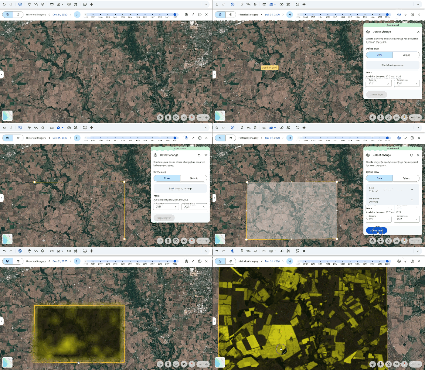
This tool calculates change on a pixel level, and the resulting layer visualizes
where change has occurred between those two years at 10-meter resolution.
### Detect change versus historical imagery
Understanding the differences between the detect change and historical imagery
tools is key to a successful analysis. While detecting year-over-year change
with detect change provides pixel-level precision, historical imagery remains an
important tool for identifying the nature of that change. By using both in
tandem, you can move from a high-level detection to a granular visual
verification in a single workflow.
| | Detect change | Historical imagery |
| **Change detection functionality** | Automated change detection using geospatial embeddings | Manual visual inspection of change |
| **Imagery** | Multi-modal embeddings including optical, multispectral, thermal, and radar imagery | Optical composite of the best available visual imagery |
| **Spatial resolution** | Consistent 10m resolution global embeddings | Ranges from 15m (satellite) to 0.15m (high-res aerial photography) |
| **Temporal frequency** | Annual only intervals | Irregular intervals (granularity can be monthly) |
|---|---|---|
## Generate custom change detection layers
1. Open an existing project or create a new one in Google Earth.
2. Click 
**Show historical imagery**
track_changes
**Detect change** or **Tools**
track_changes
**Detect change**, which opens
the tool's dialog and a preview of the heatmap at 40m resolution.
1. To see a preview of the detected change in the area, pan around the map.
2. Choose two years for comparison. The preview automatically updates to show the detected change between the selected years.
3. Change the opacity to adjust the transparency of the preview.
3. To see the full resolution of the change in an area, draw a polygon around
your area of interest, or select an existing polygon
to get started.
- Select points on the map to draw an area of interest.
- To remove a point, click undo **Undo** at the top right.
- To redraw the area of interest, click refresh **Start new**.
4. Select **Create layer** to start the analysis process.
5. When analysis is complete, a data layer will be added to your project's
**Map contents** panel. This data layer is a heatmap at 10m resolution that
shows areas where change was detected between the two years.
- Select the new data layer to open an inspector panel on the right. [Learn how to manage and style change detection data
layers](https://developers.google.com/maps/documentation/earth/manage-data-layers).
[Try now in Google Earth on web](https://earth.google.com/web/detect-change?utm_source=devsite&utm_medium=website&utm_campaign=detect_change)
## Verify results
Because the AI model behind the detect change tool combines many types of
satellite and geospatial data sources, there may be areas of change highlighted
that may not be relevant to your workflow or visible in imagery (such as soil
moisture shifts, flooding, changes in biomass, and more). We recommend using
Google Earth's visual tools to verify findings:
- **[Historical imagery](https://developers.google.com/maps/documentation/earth/historical-imagery.md.txt):** Switch to historical imagery to see high-resolution snapshots of the two comparison years and confirm the type of change is relevant.
- **[Historical Street
View](https://developers.google.com/maps/documentation/earth/historical-street-view):** Jump to ground level using Street View to confirm the nature of the change (for example, verifying if a detected change is a new warehouse or a cleared forest).
> [!NOTE]
> **Note:** The detect change tool shows change at an annual level, which may not line up neatly with individual snapshots offered by historical imagery.