Select platform: [Android](https://developers.google.com/maps/documentation/android-sdk/configure-map.md.txt "View this page for the Android platform docs.") [iOS](https://developers.google.com/maps/documentation/ios-sdk/configure-map.md.txt "View this page for the iOS platform docs.")
This overview describes how to configure a map that was added to an iOS app
using the Maps SDK for iOS.
## Overview
After you add a map to your app, you can configure initial options and runtime
settings of the map. For details about adding a map container, see the [Add a
map](https://developers.google.com/maps/documentation/ios-sdk/map).
The initial map settings include the following:
- The camera position, including: location, zoom, bearing and tilt. See [Camera and View](https://developers.google.com/maps/documentation/ios-sdk/views.md.txt) for details on camera positioning.
- The map [background color](https://developers.google.com/maps/documentation/ios-sdk/configure-map.md.txt#configure_background_color).
- The [map type](https://developers.google.com/maps/documentation/ios-sdk/configure-map.md.txt#map_types).
- The [UI components](https://developers.google.com/maps/documentation/ios-sdk/controls.md.txt) to display, such as the zoom buttons and compass.
- The [gestures](https://developers.google.com/maps/documentation/ios-sdk/controls.md.txt#map_gestures) to enable.
At runtime you can configure these settings and some addition settings by
updating the
[`GMSMapView`](https://developers.google.com/maps/documentation/ios-sdk/reference/objc/Classes/GMSMapView.md.txt)
object.
## Map options
When initializing your map view, configuration options are set with
[`GMSMapViewOptions`](https://developers.google.com/maps/documentation/ios-sdk/GMSMapViewOptions).
Option properties include the `frame`, `camera`, `mapID` or `backgroundColor`.
| Map Options ||
|---|---|
| frame | **Value:** `CGRect` The map frame. Defaults to CGRectZero. |
| camera | **Value:** `GMSCameraPosition` The default map camera position. |
| mapID | **Value:** `GMSMapID` Google mapID. Optional parameter. |
| backgroundColor | **Value:** `UIColor` Defaults to UIColor.lightGray |
### Configure map options
You can either set your own option properties, or pass an instantiated
[`GMSMapViewOptions`](https://developers.google.com/maps/documentation/ios-sdk/GMSMapViewOptions)
with default values directly to [`GMSMapView`](https://developers.google.com/maps/documentation/ios-sdk/GMSMapView).
### Swift
```swift
let options = GMSMapViewOptions()
options.camera = GMSCameraPosition.camera(withLatitude: -33.8683, longitude: 151.2086, zoom: 6)
let mapView = GMSMapView(options:options)
```
### Objective-C
```objective-c
GMSMapViewOptions *options = [[GMSMapViewOptions alloc] init];
options.camera = [GMSCameraPosition cameraWithLatitude:-33.8683
longitude:151.2086
zoom:6];
GMSMapView *mapView = [[GMSMapView alloc] initWithOptions:options];
```
Here's an example of passing a [`GMSMapViewOptions`](https://developers.google.com/maps/documentation/ios-sdk/GMSMapViewOptions) object
with default values directly to [`GMSMapView`](https://developers.google.com/maps/documentation/ios-sdk/GMSMapView).
### Swift
```swift
let options = GMSMapViewOptions()
let mapView = GMSMapView(options:options) //initialized with default values
```
### Objective-C
```objective-c
GMSMapViewOptions *options = [[GMSMapViewOptions alloc] init];
GMSMapView *mapView = [[GMSMapView alloc] initWithOptions:options]; //initialized with default values
```
### Configure background color
When working in dark mode or switching between map views, it may be useful to
override the default map background color. This can be achieved by setting the
map options `backgroundColor` property.
### Swift
```swift
let options = GMSMapViewOptions()
options.backgroundColor = UIColor.yellowColor
let mapView = GMSMapView(options:options)
```
### Objective-C
```objective-c
GMSMapViewOptions *options = [[GMSMapViewOptions alloc] init];
options.backgroundColor = UIColor.yellowColor;
GMSMapView *mapView = [[GMSMapView alloc] initWithOptions:options];
```
> [!NOTE]
> **Note:** You can also use cloud-based maps styling to configure the background color. The background color set in maps styling has a higher priority than the local background color. For more information, see [Change the app background
> color](https://developers.google.com/maps/documentation/ios-sdk/cloud-customization/app-background-leg) for cloud-based maps styling.
## Map types
You can customize your map with one of several map types. A map's type governs
the overall representation of the map. For example, an atlas usually contains
**political** maps that focus on showing boundaries, and **road** maps that show
all of the roads for a city or region. The Maps SDK for iOS offers the
following types of maps:
| Map Type ||
|---|---|
| Normal | **Value:** `kGMSTypeNormal` Typical road map. Shows roads, some features built by humans, and important natural features like rivers. Road and feature labels are also visible. Supports setting the map color scheme to dark, light, or to follow system settings. |
| Hybrid | **Value:** `kGMSTypeHybrid` Satellite photograph data with road maps added. Road and feature labels are also visible. |
| Satellite | **Value:** `kGMSTypeSatellite` Satellite photograph data. Road and feature labels are not visible. |
| Terrain | **Value:** `kGMSTypeTerrain` Topographic data. The map includes colors, contour lines and labels, and perspective shading. Some roads and labels are also visible. Supports setting the map color scheme to dark, light, or to follow system settings. |
| None | **Value:** `kGMSTypeNone` No map tiles. The base map tiles won't be rendered. This mode is useful in conjunction with [tile layers](https://developers.google.com/maps/documentation/ios-sdk/tiles.md.txt). The display of traffic data is disabled when the map type is set to none. |
### Change the map type
To set the type of a map, assign a new value to the `GMSMapView.mapType`
property. For example, to display a satellite map type:
### Swift
```swift
let options = GMSMapViewOptions()
options.camera = GMSCameraPosition.camera(withLatitude: -33.8683, longitude: 151.2086, zoom: 6)
let mapView = GMSMapView(options:options)
mapView.mapType = .satellite
```
### Objective-C
```objective-c
GMSMapViewOptions *options = [[GMSMapViewOptions alloc] init];
options.camera = [GMSCameraPosition cameraWithLatitude:-33.8683
longitude:151.2086
zoom:6];
GMSMapView *mapView = [[GMSMapView alloc] initWithOptions:options];
mapView.mapType = kGMSTypeSatellite;
```
The chooser below shows a comparison of terrain, normal and hybrid maps for the
same location:
### Indoor maps
At high zoom levels, the Maps SDK for iOS will show floor plans for
indoor spaces such as airports, shopping malls, large retail stores, and transit
stations. Indoor floor plans are integrated into the default map tiles for the
'normal' map type (`kGMSTypeNormal`), and are automatically enabled when the
user zooms in, and fade away when the map is zoomed out.
You can disable indoor maps by setting the `indoorEnabled` property of
`GMSMapView` to `NO`.
### Swift
```swift
mapView.isIndoorEnabled = false
```
### Objective-C
```objective-c
mapView.indoorEnabled = NO;
```
Alternatively, you can disable just the
[Floor Picker control](https://developers.google.com/maps/documentation/ios-sdk/reference/objc/Classes/GMSUISettings.md.txt#indoorpicker).
#### Add floor plans
Floor plans are available in [select
locations](https://support.google.com/gmm/answer/1685827).
If floor plan data is not available for a building that you would like to
highlight in your application, you can:
- [Add floor
plans](https://maps.google.com/help/maps/floorplans/) to Google Maps directly. This makes your plans are available to all users of Google Maps.
- Display a floor plan as a [Ground Overlay](https://developers.google.com/maps/documentation/ios-sdk/overlays.md.txt). This enables only users of your application to view your floor plans.
## The traffic layer
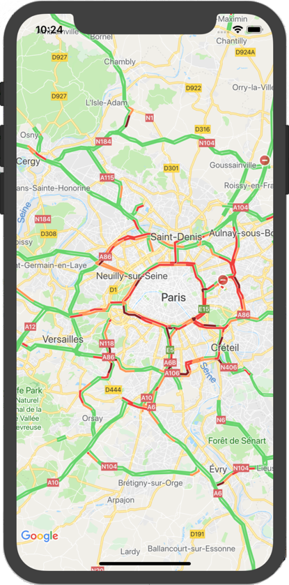
You can give your users the ability to view the map with traffic density
information superimposed on top of it. This provides a visual summary of their
local traffic situation. You can turn the traffic layer on and off by calling
the
[`trafficEnabled`](https://developers.google.com/maps/documentation/ios-sdk/reference/objc/Classes/GMSMapView.md.txt#trafficenabled)
method. The following example shows how the traffic layer might appear on a map.
## The transit layer
The Maps SDK for iOS lets you display the public transit network of a
city on your map using the
[`transitEnabled`](https://developers.google.com/maps/documentation/ios-sdk/reference/objc/Classes/GMSMapView.md.txt#transitenabled)
method. When the traffic layer is enabled, and the map is centered on a city
that supports transit information, the map will display major transit lines as
thick, colored lines. The color of the line is set based upon information from
the transit line operator. Enabling the transit layer will alter the style of
the base map to better emphasize transit routes.
If you're a public agency that oversees public transportation for your city and
would like your data to be included, visit the [Google Transit Partner
Program](https://developers.google.com/help/maps/mapcontent/transit) site to learn more.
The following example shows how the transit layer might appear on a map.

## Accessibility
By default, accessibility elements on the map are hidden. You may enable
accessibility by setting the `accessibilityElementsHidden` property of
`GMSMapView` to `NO`. This causes accessibility elements to be generated for
overlay objects (such as `GMSMarker` and info windows, `GMSPolyline` etc).
### Swift
```swift
mapView.accessibilityElementsHidden = false
```
### Objective-C
```objective-c
mapView.accessibilityElementsHidden = NO;
```
This property is as per the informal `UIAccessibility` protocol, except that the
default value in the Maps SDK for iOS is `YES`.
## My location
By default, no location data is shown on the map. You may enable the blue "My
Location" dot and compass direction by setting `myLocationEnabled` on
`GMSMapView`.
### Swift
```swift
mapView.isMyLocationEnabled = true
```
### Objective-C
```objective-c
mapView.myLocationEnabled = YES;
```
Enabling this feature provides the user's current location through the
`myLocation` property. This property may not be immediately available - for
example, if the user is prompted by iOS to allow access to this data. It is
`nil` in this case.
### Swift
```swift
print("User's location: \(String(describing: mapView.myLocation))")
```
### Objective-C
```objective-c
NSLog(@"User's location: %@", mapView.myLocation);
```
## 3D buildings
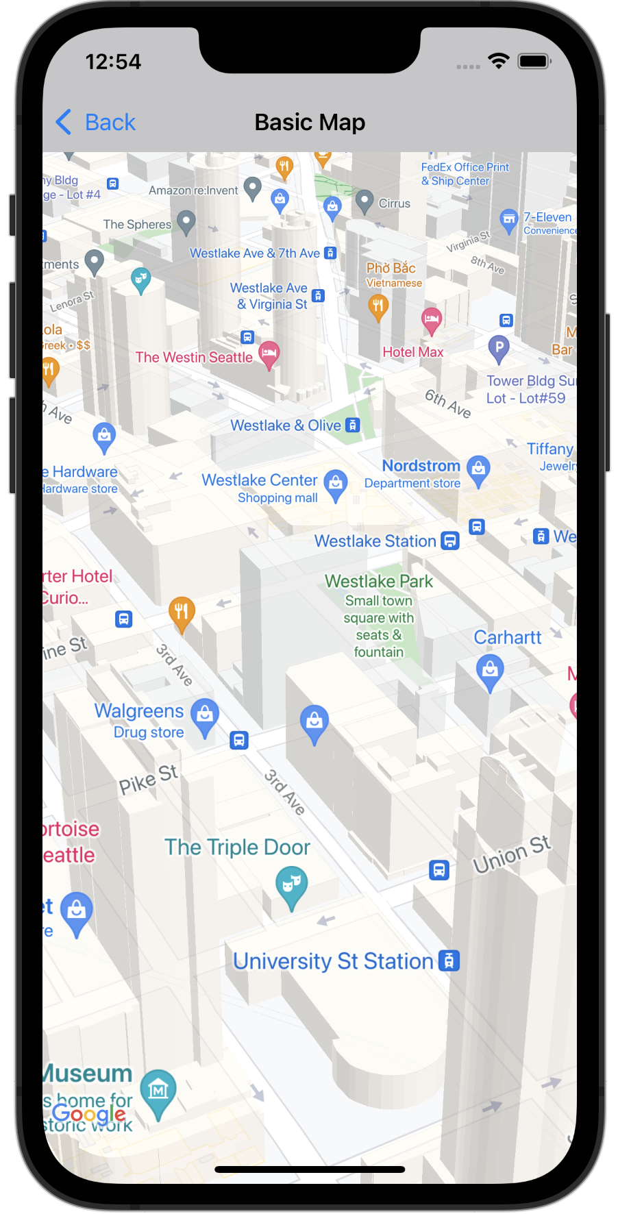
Many cities, when viewed close up, will have 3D buildings visible, as viewable
in the image of Seattle, Washington below.
You can disable the 3D buildings by setting the corresponding
[`GMSMapView`](https://developers.google.com/maps/documentation/ios-sdk/reference/objc/Classes/GMSMapView.md.txt)
property in Swift or Objective-C, as shown below:
### Swift
```swift
mapView.isBuildingsEnabled = false
```
### Objective-C
```objective-c
[mapView setBuildingsEnabled:NO];
```
## Map padding
A Google Map is designed to fill the entire region defined by the `GMSMapView`.
Several aspects of how the map appears and behaves are defined by the dimensions
of the view:
- The camera's target reflects the center of the padded region.
- Map controls are positioned relative to the edges of the map.
- Legal information, such as copyright statements or the Google logo appear along the bottom edge of the map.
You can add padding around the edges of the map using the
`GMSMapView`.[`padding`](https://developers.google.com/maps/documentation/ios-sdk/reference/objc/Classes/GMSMapView.md.txt#padding) property. The map continues to fill
the entire container, but text and control positioning, map gestures, and camera
movements behave as if it has been placed in a smaller space. This results in
the following changes:
- Camera movements using API calls or button presses (e.g., compass, my location) are relative to the padded region.
- `GMSMapView`.`projection` returns a projection that includes only the padded region.
- UI controls are offset from the edge of the container by the specified number of points.
Padding can be helpful when designing UIs that overlap some portion of the map.
For example, in the image, the map is padded along the top and right edges.
Visible map controls and legal text is displayed along the edges of the padded
region, shown in green, while the map continues to fill the entire container,
shown in blue. In this example, you could float a menu over the right side of
the map without obscuring map controls.

To add padding to your map, create a `UIEdgeInsets` object and pass it to the
`GMSMapView`.`padding` property.
### Swift
```swift
// Insets are specified in this order: top, left, bottom, right
let mapInsets = UIEdgeInsets(top: 100.0, left: 0.0, bottom: 0.0, right: 300.0)
mapView.padding = mapInsets
```
### Objective-C
```objective-c
// Insets are specified in this order: top, left, bottom, right
UIEdgeInsets mapInsets = UIEdgeInsetsMake(100.0, 0.0, 0.0, 300.0);
mapView.padding = mapInsets;
```
> [!NOTE]
> **Note:** As specified in the [Google Maps Platform Terms of Service](https://cloud.google.com/maps-platform/terms), your application must not remove or obscure the Google logo or copyright notices. Map Padding lets you reposition these elements if necessary. If you display a custom UI at the bottom of the map, add padding to the bottom of the map so that the logo and legal notices are visible.
## Map color scheme
For maps of type normal and terrain, you can set the map color scheme to dark,
light, or to use the current system settings. For example, you can darken or
lighten the map color scheme based on the time of day or indoor or outdoor use
of the device.
Use [`GMSMapView
overrideUserInterfaceStyle:`](https://developers.google.com/maps/documentation/ios-sdk/reference/objc/Classes/GMSMapView#overrideuserinterfacestyle)
to set and update the map color scheme.
### Swift
```swift
let options = GMSMapViewOptions()
// Map is init to use light mode by default.
let mapView = GMSMapView(options: options)
// Set map to use dark mode.
mapView.overrideUserInterfaceStyle = .dark
// Set map to use light mode.
mapView.overrideUserInterfaceStyle = .light
// Set map to use dark/light mode based on the value of traitCollection.userInterfaceStyle
mapView.overrideUserInterfaceStyle = .unspecified
```
### Objective-C
```objective-c
GMSMapViewOptions *options = [[GMSMapViewOptions alloc] init];
// Map is init to always use light mode.
GMSMapView *mapView = [[GMSMapView alloc] initWithOptions:options];
// Set map to use dark mode.
mapView.overrideUserInterfaceStyle = UIUserInterfaceStyleDark;
// Set map to use light mode.
mapView.overrideUserInterfaceStyle = UIUserInterfaceStyleLight;
// Set map to use dark/light mode based on the value of traitCollection.userInterfaceStyle
mapView.overrideUserInterfaceStyle = UIUserInterfaceStyleUnspecified;
```
To create custom light styles and dark styles for your maps, use
[cloud-based maps styling](https://developers.google.com/maps/documentation/ios-sdk/cloud-customization.md.txt).