> [!WARNING]
> This product or feature is Experimental (pre-GA). Pre-GA products and features might have limited support, and changes to pre-GA products and features might not be compatible with other pre-GA versions. Pre-GA Offerings are covered by the [Google
> Maps Platform Service Specific Terms](https://cloud.google.com/maps-platform/terms/maps-service-terms). For more information, see the [launch stage descriptions](https://developers.google.com/maps/launch-stages.md.txt).
The `mapTypes` endpoint provides raster map tiles representing various weather
phenomena, such as precipitation forecasts. These map tiles can be overlaid onto
standard Google Maps.
> [!NOTE]
> **Note:** Weather map tiles may not be synchronized or align with the data provided by the [`forecast:minute`](https://developers.google.com/maps/documentation/weather/minute-forecast.md.txt) endpoint.
## Terms
These terms are issued under Section 6 (Pre-GA Offerings Terms) of the [Google
Maps Platform Service Specific
Terms](https://cloud.google.com/maps-platform/terms/maps-service-terms), as
agreed to by Google and you.
1.1 *Attribution Requirements.* Customer must provide Google with attribution in
accordance with the [Documentation](https://developers.google.com/maps/documentation/weather/weather-map.md.txt#attribution) if Customer uses Google Maps
Content from the Weather API.
1.2 *Restrictions.* Customers can not use Google Maps Content retrieved from
Weather API to recreate a Google service or product (e.g. use data retrieved
from Weather API in a weather app or weather model whose primary purpose is to
provide weather information).
1.3 *Caching.* Customers can temporarily cache the applicable Google Maps
Content from the Weather API for the applicable Caching Period, as described in
Table 1.3.1 (Caching Permissions).
**Table 1.3.1 (Caching Permissions)**
These permissions are in addition to those described in [Table
17.2.1](https://cloud.google.com/maps-platform/terms/maps-service-terms)
of the Google Maps Platform Service Specific Terms.
| Google Maps Content | Caching Period |
|---|---|
| Weather map tiles | One hour, after which Customer must delete the cached Google Maps Content |
## About weather map requests
To request weather maps, send an HTTP GET request to:
```html
https://weather.googleapis.com/v1/mapTypes/{map_type}/mapTiles/{zoom}/{x}/{y}
```
### Map types
The Weather API supports different weather map types, which correspond to
different underlying weather models and geographic areas:
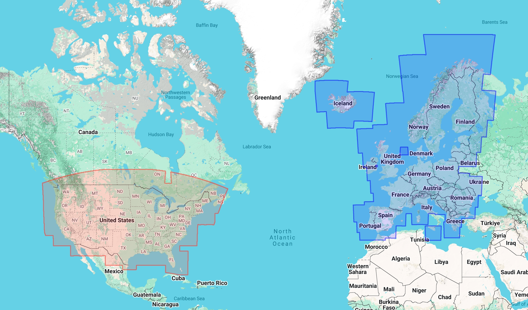
- `US_PRECIPITATION_CURRENT`: High-resolution United States precipitation nowcast.
- `EU_PRECIPITATION_CURRENT`: High-resolution European precipitation nowcast.
The coverage map below shows the regions where weather map tiles are available:
### Tile coordinates system
The API uses the standard Web Mercator tile coordinate system. For a
comprehensive explanation of map and tile coordinates, see [Roadmap
tiles](https://developers.google.com/maps/documentation/tile/roadmap) and [Map and Tile
Coordinates](https://developers.google.com/maps/documentation/javascript/coordinates).
In this system:
- `zoom`: The zoom level (0 to 16). Zoom level 0 represents the entire world in a single tile (2^0^ x 2^0^ = 1 tile). Zoom level z divides the world into a grid of 2^z^ x 2^z^ tiles.
- `x`: The X coordinate (column) of the tile, ranging from 0 (westernmost) to 2^zoom^ - 1 (easternmost).
- `y`: The Y coordinate (row) of the tile, ranging from 0 (northernmost) to 2^zoom^ - 1 (southernmost).
## Display weather map
To display these tiles in a web application using the Google Maps JavaScript
API, you can create a custom `google.maps.ImageMapType`:
```javascript
const weatherMapType = new google.maps.ImageMapType({
getTileUrl: function(coord, zoom) {
const mapType = "US_PRECIPITATION_CURRENT";
return `https://weather.googleapis.com/v1/mapTypes/${mapType}/mapTiles/${zoom}/${coord.x}/${coord.y}`;
},
tileSize: new google.maps.Size(256, 256),
maxZoom: 16,
minZoom: 0,
name: "Weather"
});
// Overlay on existing map
map.overlayMapTypes.insertAt(0, weatherMapType);
```
## Weather map request example
The following example requests US precipitation weather map tiles for New
Orleans:
```
curl -o tile.png -X GET "https://weather.googleapis.com/v1/mapTypes/US_PRECIPITATION_CURRENT/mapTiles/12/1025/1688?key=API_KEY"
```
The response is binary. The JSON wrapper only appears under specific
serialization settings, such as `?alt=json`.