
Page Summary
-
This page outlines how to set up Public Alerts for cyclones using a Tropical Storm Forecast geometry feed.
-
The Tropical Storm Forecast geometry feed requires specific files for storm center points, track line, and cone polygon, contained within a ZIP file linked in the feed.
-
A unique
StormIDmust be included in both the geometry feed and corresponding CAP alerts to link the forecast visualization with the alert information. -
The CAP alert should include a
<parameter>element withvalueNameasStormIdandvalueas the unique storm identifier. -
Google requires the feed URL and an explanation of the ZIP file structure, including column names for Storm ID, latitude, and longitude, for setup.
This page provides information about how to set up Public Alerts for cyclones.
Special recommendations to support Tropical Storm Forecast geometry
In the Public Alerts Tropical Storm Forecast, tropical storms are visualized as follows:
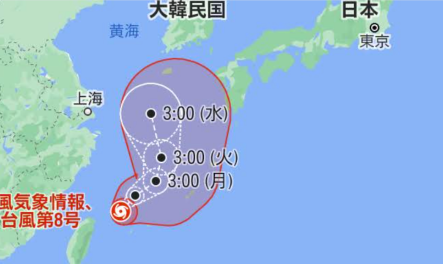
To enable this type of visualization, Google requires a Common Alerting Protocol (CAP) feed that contains the alert information and contains a new feed that specifies the storm's geometry.
Details on the feed that contains the Tropical Storm Forecast geometry
In the feed, make sure to include the following information:
A feed file that contains information about different tropical storms and contains the URLs for the data files that include the forecast geometry data files. The following sample, taken from an NOAA feed, provides an example of an XML feed file's content:
<item>
  <title>
    Advisory #024 Forecast [shp] - Tropical Storm Walaka (CP1/CP012018)
  </title>
  <description>
    Forecast Track, Cone of Uncertainty, Watches/Warnings. Shapefile last updated 05 Oct 2018 14:52:04 GMT.
  </description>
  <link>http://www.prh.noaa.gov/cphc/tc_graphics/2018/gis/cp012018_5day_024.zip
  </link>
</item>
In the
<link>section shown in the previous sample, include a ZIP file that contains files that represent the forecast geometry of the mentioned tropical storm. The ZIP file needs to include the following files:- A file that contains the storm center forecast points.
- A file that contains the center forecast track line.
- A file that contains the forecast cone polygon.
Each of these files must have a different file name suffix to differentiate them while processing.
We recommend that the forecast contain the time when the forecast starts and when it expires. For some sample data, see the NHC forecast archives.
For example, the NHC forecast file
al012021_5day_001.zip
contains the following files:
al012021-001_5day_lin.shpal012021-001_5day_pgn.shpal012021-001_5day_pts.shpal012021-001_ww_wwlin.shp
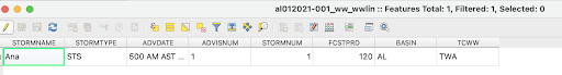
The attribute table for al012021-001_ww_wwlin.shp contains a column named
STORMNUM, whose value is used as StormID in the feed.
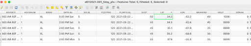
The attribute table for al012021-001_5day_pts.shp uses the columns LAT and
LON to denote the latitude and longitude information, respectively.
Additional parameters in CAP feeds
When the publisher sends the alerts for Tropical Storm, Typhoon, or Cyclone
events types, they need to mention the unique storm ID. One approach is to use the
<info> and <parameter> elements from the CAP format section 3.2.2 "info"
Element and Sub-elements:
<parameter>
  <valueName>StormId</valueName>
  <value>UniqueStormID</value>
</parameter>
In the previous NHC example, the storm ID that's stored in the
shape file is 1. The CAP feed must include a parameter element to tell Public
Alerts which storm the Forecast Geometry feed is for:
<parameter>
  <valueName>StormId</valueName>
  <value>1</value>
</parameter>
Important points on data quality
- The
StormIDmust be unique for the same active storm. - Use the same
StormIDfor the<identifier>field when you want to publish this storm into your CAP alerts later. You can raise multiple alerts with different details for various regions for the same storm, as long as the sameStormIDis used as<identifier>in your CAP alerts. - For more info on a sample feed, see the NHC forecast archives.
Checklist to submit your feed to Google
When you share the Tropical Storm Forecast feed with Google, be sure to include the following:
- Feed URL
- Explanation of the structure of the ZIP file that contains your forecast
geometry:
- Which file specifies the storm center forecast points
- Which file specifies the center forecast track line
- Which file specifies the forecast cone polygon
- Which column names denote the Storm ID, latitude, and longitude