Auf dieser Seite erfahren Sie, wie Sie programmatisch auf ein Dataset zugreifen und dessen Elemente gestalten können. Außerdem werden Gestaltungsbeispiele für Datenelemente auf Basis von Punkt-, Polygon- und Polyliniengeometrien erläutert.
Mit datengestützten Stilen für Datasets werden Datenelemente auf Grundlage der bereitgestellten Breiten- und Längengradkoordinaten der Geodatendatei gerendert, aus der das Dataset erstellt wurde.
Beispiel für Punktdatenstil
Dieses Beispiel zeigt eine Methode, um auf Punktgeometrie basierende Datenelemente zu gestalten.

Über das Dataset
Das in diesem Beispiel verwendete Dataset ist das Ergebnis einer Erhebung aus dem Jahr 2018 über Eichhörnchen im New Yorker Central Park. Im folgenden Auszug aus der CSV-Datendatei werden die Spalten x und y für den Standort verwendet. Die Spalte LatLng ist vorhanden, wird im Beispiel aber nicht verwendet, weil Datasets nur das WKT-Format unterstützen, wenn die Spalte den Namen WKT hat. Weitere Informationen zu den unterstützten Formaten für den Standort finden Sie unter CSV-Vorgaben.
Das Dataset der Eichhörnchenzählung enthält viele verschiedene Datenpunkte, die sich auf die beobachtete Fellfarbe und das Verhalten der Eichhörnchen beziehen. Scrollen Sie nach rechts, um alle Daten zu sehen.
| X | Y | UniqueSquirrelID | Hectare | Shift | Date | Hectare SquirrelNumber | Age | PrimaryFurColor | HighlightFurColor | CombinationofPrimaryandHighlightColor | Colornotes | Location | AboveGroundSighter Measurement | SpecificLocation | Running | Chasing | Climbing | Eating | Foraging | Other Activities | Kuks | Quaas | Moans | Tailflags | Tailtwitches | Approaches | Indifferent | Runsfrom | OtherInteractions | LatLng |
|---|---|---|---|---|---|---|---|---|---|---|---|---|---|---|---|---|---|---|---|---|---|---|---|---|---|---|---|---|---|---|
| -73.9561344937861 | 40.7940823884086 | 37F-PM-1014-03 | 37F | PM | 10142018 | 3 | + | false | false | false | false | false | false | false | false | false | false | false | false | false | POINT (-73.9561344937861 40.7940823884086) | |||||||||
| -73.9688574691102 | 40.7837825208444 | 21B-AM-1019-04 | 21B | AM | 10192018 | 4 | + | false | false | false | false | false | false | false | false | false | false | false | false | false | POINT (-73.9688574691102 40.7837825208444) | |||||||||
| -73.9742811484852 | 40.775533619083 | 11B-PM-1014-08 | 11B | PM | 10142018 | 8 | Gray | Gray+ | Above Ground | 10 | false | true | false | false | false | false | false | false | false | false | false | false | false | POINT (-73.97428114848522 40.775533619083) | ||||||
| -73.9596413903948 | 40.7903128889029 | 32E-PM-1017-14 | 32E | PM | 10172018 | 14 | Adult | Gray | Gray+ | Nothing selected as Primary. Gray selected as Highlights. Made executive adjustments. | false | false | false | true | true | false | false | false | false | false | false | false | true | POINT (-73.9596413903948 40.7903128889029) | ||||||
| -73.9702676472613 | 40.7762126854894 | 13E-AM-1017-05 | 13E | AM | 10172018 | 5 | Adult | Gray | Cinnamon | Gray+Cinnamon | Above Ground | on tree stump | false | false | false | false | true | false | false | false | false | false | false | false | false | POINT (-73.9702676472613 40.7762126854894) | ||||
| -73.9683613516225 | 40.7725908847499 | 11H-AM-1010-03 | 11H | AM | 10102018 | 3 | Adult | Cinnamon | White | Cinnamon+White | false | false | false | false | true | false | false | false | false | true | false | true | false | POINT (-73.9683613516225 40.7725908847499) | ||||||
| -73.9541201789795 | 40.7931811701082 | 36H-AM-1010-02 | 36H | AM | 10102018 | 2 | Adult | Gray | Gray+ | just outside hectare | Ground Plane | FALSE | false | false | false | false | true | false | false | false | false | false | false | false | false | POINT (-73.9541201789795 40.7931811701082) |
Stil für Punktdaten-Elemente
In diesem Beispiel wird beim Code eine einfache Methode angewendet: Die Füll- und Strichfarbe für jeden Punkt wird basierend auf dem Attribut CombinationofPrimaryandHighlightColor gestaltet. Dabei werden die primären und sekundären Fellfarben für jedes Eichhörnchen kombiniert.
Kotlin
private fun styleDatasetsLayer() {

  // Create the style factory function.
  val styleFactory = FeatureLayer.StyleFactory { feature: Feature ->

      // Set default colors to to yellow and point radius to 8.
      var fillColor = Color.YELLOW
      var strokeColor = Color.YELLOW
      var pointRadius = 8F
      // Check if the feature is an instance of DatasetFeature.
      if (feature is DatasetFeature) {

        val furColors: MutableMap<String, String> = feature.getDatasetAttributes()
        // Determine CombinationofPrimaryandHighlightColor attribute.
        val furColor = furColors!!["CombinationofPrimaryandHighlightColor"]
        when (furColor) {
          "Black+" -> {
            fillColor = Color.BLACK
            strokeColor= Color.BLACK
          }
          "Cinnamon+" ->  {
            fillColor = -0x750000
            strokeColor= -0x750000
          }
          "Cinnamon+Gray" -> {
            fillColor = -0x750000
            strokeColor= -0x750000
            pointRadius = 6F
          }
          "Cinnamon+White" -> {
            fillColor = -0x750000
            strokeColor= Color.WHITE
            pointRadius = 6F
          }
          "Gray+" -> fillColor = Color.GRAY
          "Gray+Cinnamon" -> {
            fillColor = Color.GRAY
            strokeColor= -0x750000
            pointRadius = 6F
          }
          "Gray+Cinnamon, White" -> {
            fillColor = Color.LTGRAY
            strokeColor= -0x750000
            pointRadius = 6F
          }
          "Gray+White" -> {
            fillColor = Color.GRAY
            strokeColor= Color.WHITE
            pointRadius = 6F
          }
        }
        return@StyleFactory FeatureStyle.Builder()
          .fillColor(fillColor)
          .strokeColor(strokeColor)
          .pointRadius(pointRadius)
          .build()
      }
    return@StyleFactory null
  }

  // Apply the style factory function to the feature layer.
  datasetLayer?.setFeatureStyle(styleFactory)
}
Java
private void styleDatasetsLayer() {

  // Create the style factory function.
  FeatureLayer.StyleFactory styleFactory = (Feature feature) -> {

    // Check if the feature is an instance of DatasetFeature.
    if (feature instanceof DatasetFeature) {

      // Determine CombinationofPrimaryandHighlightColor attribute.
      Map<String, String> furColors = ((DatasetFeature) feature).getDatasetAttributes();
      String furColor = furColors.get("CombinationofPrimaryandHighlightColor");
      // Set default colors to to yellow and point radius to 8.
      int fillColor = Color.YELLOW;
      int strokeColor = Color.YELLOW;
      int pointRadius = 8;
      switch (furColor) {
        case "Black+":
          fillColor = Color.BLACK;
          strokeColor = Color.BLACK;
          break;
        case "Cinnamon+":
          fillColor = 0xff8b0000;
          strokeColor = 0xff8b0000;
          break;
        case "Cinnamon+Gray":
          fillColor = 0xff8b0000;
          strokeColor = Color.GRAY;
          pointRadius = 6;
          break;
        case "Cinnamon+White":
          fillColor = 0xff8b0000;
          strokeColor = Color.WHITE;
          pointRadius = 6;
          break;
        case "Gray+":
          fillColor = Color.GRAY;
          strokeColor = Color.GRAY;
          break;
        case "Gray+Cinnamon":
          fillColor = Color.GRAY;
          strokeColor = 0xff8b0000;
          pointRadius = 6;
          break;
        case "Gray+Cinnamon, White":
          fillColor = Color.LTGRAY;
          strokeColor = 0xff8b0000;
          pointRadius = 6;
          break;
        case "Gray+White":
          fillColor = Color.GRAY;
          strokeColor = Color.WHITE;
          pointRadius = 6;
          break;
        default:
          fillColor = Color.YELLOW;
          strokeColor = Color.YELLOW;
          pointRadius = 8;
      }
      return new FeatureStyle.Builder()
        .fillColor(fillColor)
        .strokeColor(strokeColor)
        .pointRadius(pointRadius)
        .build();
    }
    return null;
  };

  // Apply the style factory function to the feature layer.
  datasetLayer.setFeatureStyle(styleFactory);
}
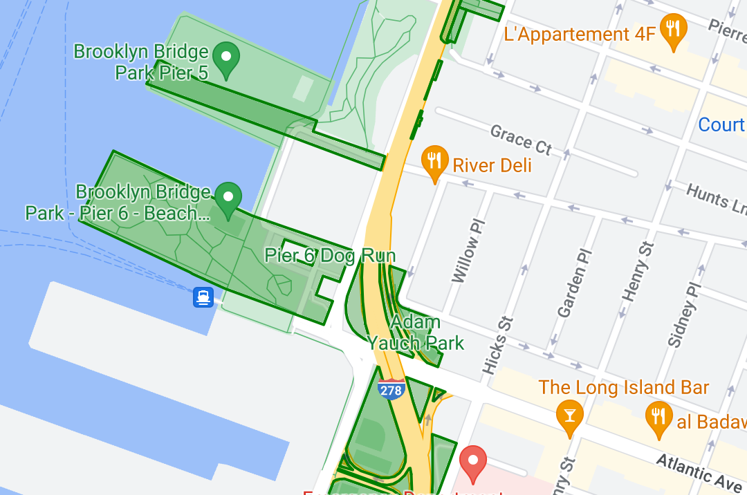
Beispiel für Polygondatenstil
Dieses Beispiel zeigt eine Methode, um auf Polygongeometrie basierende Datenelemente zu gestalten.

Über das Dataset
Das in diesem Beispiel verwendete Dataset stellt Parks in New York City dar. Der folgende Auszug aus der GeoJSON-Datei des Datasets zeigt einen repräsentativen Element-Eintrag.
{
  "type": "Feature",
  "properties": {
    "jurisdiction": "DPR",
    "mapped": "False",
    "zipcode": "11356",
    "acres": "0.05",
    "location": "College Pl., College Pt. Blvd., bet. 11 Ave. and 12 Ave.",
    "nys_assembly": "27",
    "councildistrict": "19",
    "url": "http://www.nycgovparks.org/parks/Q042/",
    "typecategory": "Triangle/Plaza",
    "us_congress": "14",
    "eapply": "Poppenhusen Park",
    "parentid": "Q-07",
    "gispropnum": "Q042",
    "retired": "false",
    "communityboard": "407",
    "objectid": "6248",
    "globalid": "F4810079-CBB9-4BE7-BBFA-B3C0C35D5DE5",
    "name311": "Poppenhusen Park",
    "department": "Q-07",
    "pip_ratable": "true",
    "subcategory": "Sitting Area/Triangle/Mall",
    "precinct": "109",
    "permit": "true",
    "acquisitiondate": null,
    "omppropid": "Q042",
    "gisobjid": "100000301",
    "signname": "Poppenhusen Park",
    "address": null,
    "permitparent": "Q-07",
    "class": "PARK",
    "nys_senate": "11",
    "permitdistrict": "Q-07",
    "borough": "Q",
    "waterfront": "false"
  },
  "geometry": {
    "type": "MultiPolygon",
    "coordinates": [
      [
        [
          [
            -73.84575702371716,
            40.78796240884273
          ],
          [
            -73.84593393292693,
            40.78796857347548
          ],
          [
            -73.84577256469657,
            40.787651355629556
          ],
          [
            -73.84575702371716,
            40.78796240884273
          ]
        ]
      ]
    ]
  }
},
Stil für Polygondaten-Elemente
Mit dem Code in diesem Beispiel erhalten Datenelemente, die mit einer typecategory „UnDeveloped“ oder „Parkway“ verknüpft sind, eine besondere Farbgebung. Alle anderen Elemente erhalten die Farbe Grün.
Kotlin
private fun styleDatasetsLayer() {

    // Create the style factory function.
    val styleFactory = FeatureLayer.StyleFactory { feature: Feature ->

        // Check if the feature is an instance of DatasetFeature.
        if (feature is DatasetFeature) {
          // Determine the value of the typecategory attribute.
          val typeCategories: MutableMap<String, String> = feature.getDatasetAttributes()
          val typeCategory = typeCategories!!["typecategory"]
          // Set default colors to green.
          var fillColor = 0x4000ff00
          var strokeColor = 0xff00ff00
          when (typeCategory) {
            "Undeveloped" -> {
              // Color undeveloped areas blue.
              fillColor = 0x400000ff
              strokeColor = 0x400000ff
            }
            "Parkway" -> {
              // Color parkway areas red.
              fillColor = 0x40ff0000
              strokeColor = 0x40ff0000
            }
            else -> {
              // Color all other areas green.
              fillColor = 0x4000ff00
              strokeColor = 0xff00ff00
            }
          }
          return@StyleFactory FeatureStyle.Builder()
            .fillColor(fillColor)
            .strokeColor(strokeColor)
            .strokeWidth(2F)
            .build()
        }
        return@StyleFactory null
    }

    // Apply the style factory function to the feature layer.
    datasetLayer?.setFeatureStyle(styleFactory)
}
Java
private void styleDatasetsLayer() {

    // Create the style factory function.
    FeatureLayer.StyleFactory styleFactory = (Feature feature) -> {

      // Check if the feature is an instance of DatasetFeature.
      if (feature instanceof DatasetFeature) {

        // Determine the value of the typecategory attribute.
        Map<String, String> typeCategories = ((DatasetFeature) feature).getDatasetAttributes();
        String typeCategory = typeCategories.get("typecategory");
        // Set default colors to green.
        int fillColor = 0x4000ff00;
        int strokeColor = 0xff00ff00;
        switch (typeCategory) {
          case "Undeveloped":
            // Color undeveloped areas blue.
            fillColor = 0x400000ff;
            strokeColor = 0xff0000ff;
            break;
          case "Parkway":
            // Color parkway areas red.
            fillColor = 0x40ff0000;
            strokeColor = 0xffff0000;
            break;
          default:
            // Color all other areas green.
            fillColor = 0x4000ff00;
            strokeColor = 0xff00ff00;
        }
        return new FeatureStyle.Builder()
          .fillColor(fillColor)
          .strokeColor(strokeColor)
          .strokeWidth(2)
          .build();
      }
      return null;
    };

    // Apply the style factory function to the feature layer.
    datasetLayer.setFeatureStyle(styleFactory);
}
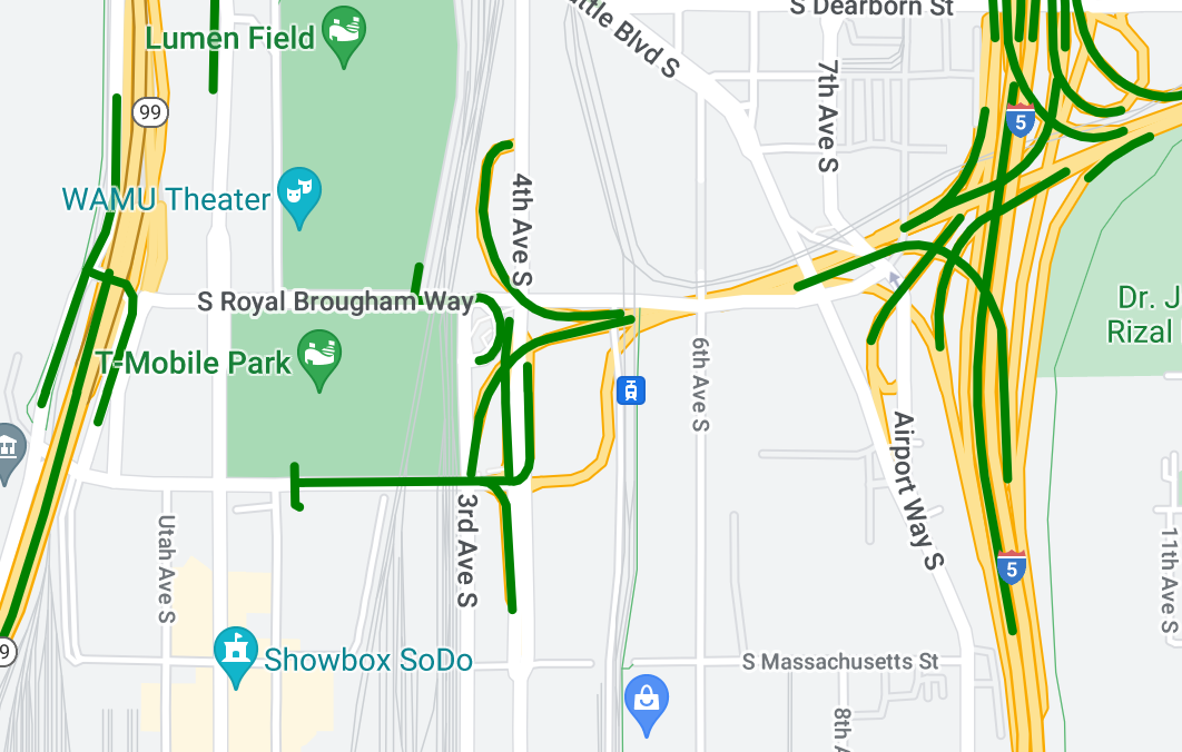
Beispiel für Polyliniendatenstil
Dieses Beispiel zeigt eine Methode, um auf Polyliniengeometrie basierende Datenelemente zu gestalten.

Über das Dataset
Das in diesem Beispiel verwendete Dataset stellt Brücken im Raum Seattle dar. Der folgende Auszug aus der GeoJSON-Datei des Datasets zeigt einen repräsentativen Element-Eintrag.
{
  "type": "Feature",
  "properties": {
      "OBJECTID": 1,
      "COMPTYPE": 66,
      "COMPKEY": 515774,
      "HANSEGKEY": 489781,
      "UNITID": "BRG-935",
      "UNITTYPE": " ",
      "BRGUNITID": "BRG-935",
      "UNITDESC_BRG": "YALE AVE BR REV LANE OC                                                                                                                                                                                                                                        ",
      "UNITDESC_SEG": "HOWELL ST ON RP BETWEEN HOWELL ST AND I5 SB                                                                                                                                                                                                                    ",
      "INSTDATE": null,
      "EXPDATE": null,
      "STATUS": " ",
      "STATUSDT": null,
      "CONDITION": " ",
      "CONDDT": null,
      "OWN": " ",
      "LSTVERIFY": null,
      "MAINTBY": " ",
      "ADDBY": "GARCIAA",
      "ADDDTTM": "2010-01-21T00:00:00Z",
      "MODBY": null,
      "MODDTTM": null,
      "BR_NBR": 935,
      "BR_CODE": " 935",
      "BR_TYPE": "ST",
      "BR_NAME": "YALE AVE BR REV LANE OC",
      "BR_FACILITIES": "YALE AVE-SR 5 ON RAMP",
      "BR_FEATURES": "SR 5 REV LANE",
      "BR_RATING": 0,
      "BR_INSET": 1,
      "BR_GEO": "DT",
      "BR_OWNER": "DOT",
      "BR_OWNER_NAME": "State of Washington",
      "GEOBASID": 0,
      "XGEOBASID": 0,
      "GISSEGKEY": 489781,
      "EARTHQUAKE_RESPONSE_TEAM": " ",
      "SHAPE_Length": 220.11891836147655
  },
  "geometry": {
      "type": "LineString",
      "coordinates": [
          [
              -122.329201929090928,
              47.616910448708538
          ],
          [
              -122.329206483407461,
              47.616976719821004
          ],
          [
              -122.32921802149356,
              47.617042137515213
          ],
          [
              -122.329236413912909,
              47.617105967923777
          ],
          [
              -122.329261454336034,
              47.617167494985758
          ],
          [
              -122.329292861855023,
              47.617226028479571
          ],
          [
              -122.329330284134699,
              47.617280911766009
          ],
          [
              -122.329373301365223,
              47.617331529154569
          ],
          [
              -122.329421430971635,
              47.617377312810319
          ],
          [
              -122.329474133027375,
              47.617417749124023
          ],
          [
              -122.32953081631139,
              47.617452384473893
          ]
      ]
  }
},
Stil für Polyliniendaten-Elemente
Im folgenden Snippet wird derselbe Stil direkt auf alle Datenelemente angewendet.
Kotlin
private fun styleDatasetsLayer() {

  // Create the style factory function.
  val styleFactory = FeatureLayer.StyleFactory { feature: Feature ->

    // Check if the feature is an instance of DatasetFeature.
    if (feature is DatasetFeature) {

      return@StyleFactory FeatureStyle.Builder()
        // Define a style with green stroke with a width of 4.
        .strokeColor(0xff00ff00.toInt())
        .strokeWidth(4F)
        .build()
    }
    return@StyleFactory null
  }

  // Apply the style factory function to the feature layer.
  datasetLayer?.setFeatureStyle(styleFactory)
}
Java
private void styleDatasetsLayer() {

  // Create the style factory function.
  FeatureLayer.StyleFactory styleFactory = (Feature feature) -> {

    // Check if the feature is an instance of DatasetFeature.
    if (feature instanceof DatasetFeature) {

      return new FeatureStyle.Builder()
        // Define a style with green stroke with a width of 4.
        .strokeColor(0xff00ff00)
        .strokeWidth(4)
        .build();
    }
    return null;
  };

  // Apply the style factory function to the feature layer.
  datasetLayer.setFeatureStyle(styleFactory);
}
