একটি মানচিত্রে পলিলাইন আঁকুন
সেভ করা পৃষ্ঠা গুছিয়ে রাখতে 'সংগ্রহ' ব্যবহার করুন
আপনার পছন্দ অনুযায়ী কন্টেন্ট সেভ করুন ও সঠিক বিভাগে রাখুন।

এই উদাহরণটি উত্তর আটলান্টিক মহাসাগরের একটি মানচিত্র প্রদর্শন করে যার উপর টাইটানিকের রুট আঁকা হয়েছে।
শুরু করুন
আপনি নমুনা কোড চেষ্টা করার আগে, আপনি আপনার উন্নয়ন পরিবেশ কনফিগার করতে হবে. আরও তথ্যের জন্য, একটি ফ্লাটার প্রকল্প সেট আপ দেখুন।
কোডটি দেখুন
ডার্ট
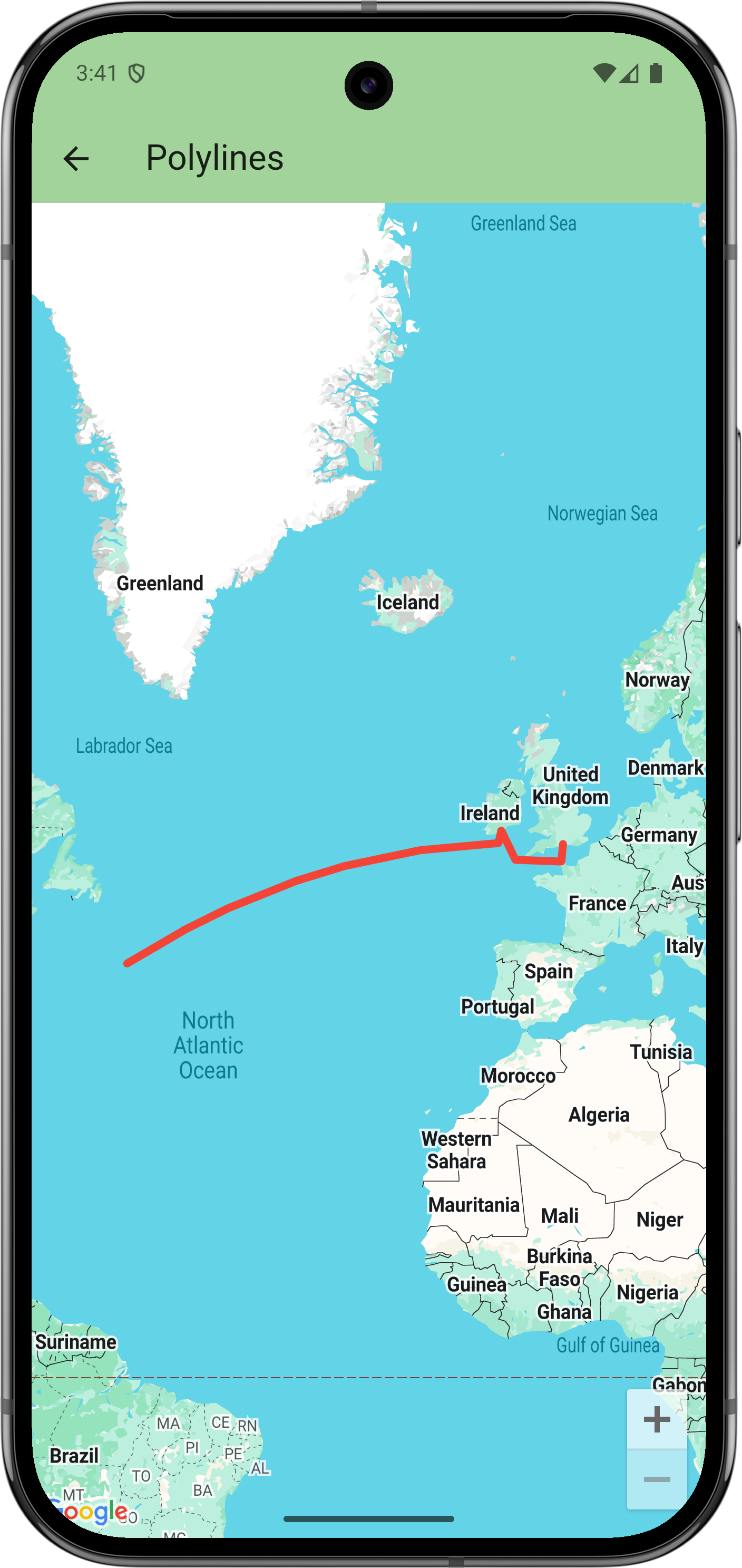
// Copyright 2025 Google LLC
//
// Licensed under the Apache License, Version 2.0 (the "License");
// you may not use this file except in compliance with the License.
// You may obtain a copy of the License at
//
// https://www.apache.org/licenses/LICENSE-2.0
//
// Unless required by applicable law or agreed to in writing, software
// distributed under the License is distributed on an "AS IS" BASIS,
// WITHOUT WARRANTIES OR CONDITIONS OF ANY KIND, either express or implied.
// See the License for the specific language governing permissions and
// limitations under the License.
import 'package:flutter/material.dart';
import 'package:google_maps_flutter/google_maps_flutter.dart';
/// Displays a map of the North Atlantic Ocean with the route of the Titanic
/// marked on it.
class PolylinesSample extends StatelessWidget {
const PolylinesSample({super.key});
@override
Widget build(BuildContext context) {
return GoogleMap(
initialCameraPosition: CameraPosition(target: LatLng(49, -23)),
polylines: {
Polyline(
// Polyline id must be unique.
polylineId: PolylineId('titanic route'),
points: [
LatLng(50.90, -1.41), // Southampton
LatLng(49.65, -1.60), // Cherbourg
LatLng(49.77, -6.71),
LatLng(51.83, -8.28), // Cobh
LatLng(50.96, -8.58),
LatLng(41.75, -49.90), // Wreck
],
width: 5,
color: Colors.red,
geodesic: true,
// Custom caps and joint types aren't supported on all platforms.
startCap: Cap.roundCap,
endCap: Cap.roundCap,
jointType: JointType.round,
consumeTapEvents: true,
onTap: () => debugPrint('clicked route'),
),
},
);
}
}
পরবর্তী পদক্ষেপ
GitHub-এ নমুনার সম্পূর্ণ সেট দেখুন:
GitHub এ দেখুন
বিকল্পভাবে, নিম্নলিখিত কমান্ডগুলি সম্পাদন করে স্থানীয়ভাবে চালানোর জন্য নমুনার সম্পূর্ণ সেট ক্লোন করুন:
git clone -b flutter_samples https://github.com/googlemaps-samples/flutter-maps-samples.git
cd flutter-samples
flutter pub get
অন্য কিছু উল্লেখ না করা থাকলে, এই পৃষ্ঠার কন্টেন্ট Creative Commons Attribution 4.0 License-এর অধীনে এবং কোডের নমুনাগুলি Apache 2.0 License-এর অধীনে লাইসেন্স প্রাপ্ত। আরও জানতে, Google Developers সাইট নীতি দেখুন। Java হল Oracle এবং/অথবা তার অ্যাফিলিয়েট সংস্থার রেজিস্টার্ড ট্রেডমার্ক।
2025-09-03 UTC-তে শেষবার আপডেট করা হয়েছে।
[null,null,["2025-09-03 UTC-তে শেষবার আপডেট করা হয়েছে।"],[],[],null,["# Draw polylines on a map\n\nThis example displays a map of the North Atlantic Ocean with the route of the Titanic drawn on it.\n\nGet started\n-----------\n\nBefore you can try the sample code, you must configure your development environment.\nFor more information, see [Set up a Flutter project](/maps/flutter-package/config).\n\nView the code\n-------------\n\n### Dart\n\n```python\n// Copyright 2025 Google LLC\n//\n// Licensed under the Apache License, Version 2.0 (the \"License\");\n// you may not use this file except in compliance with the License.\n// You may obtain a copy of the License at\n//\n// https://www.apache.org/licenses/LICENSE-2.0\n//\n// Unless required by applicable law or agreed to in writing, software\n// distributed under the License is distributed on an \"AS IS\" BASIS,\n// WITHOUT WARRANTIES OR CONDITIONS OF ANY KIND, either express or implied.\n// See the License for the specific language governing permissions and\n// limitations under the License.\n\nimport 'package:flutter/material.dart';\nimport 'package:google_maps_flutter/google_maps_flutter.dart';\n\n/// Displays a map of the North Atlantic Ocean with the route of the Titanic\n/// marked on it.\nclass PolylinesSample extends StatelessWidget {\n const PolylinesSample({super.key});\n\n @override\n Widget build(BuildContext context) {\n return GoogleMap(\n initialCameraPosition: CameraPosition(target: LatLng(49, -23)),\n polylines: {\n Polyline(\n // Polyline id must be unique.\n polylineId: PolylineId('titanic route'),\n points: [\n LatLng(50.90, -1.41), // Southampton\n LatLng(49.65, -1.60), // Cherbourg\n LatLng(49.77, -6.71),\n LatLng(51.83, -8.28), // Cobh\n LatLng(50.96, -8.58),\n LatLng(41.75, -49.90), // Wreck\n ],\n width: 5,\n color: Colors.red,\n geodesic: true,\n // Custom caps and joint types aren't supported on all platforms.\n startCap: Cap.roundCap,\n endCap: Cap.roundCap,\n jointType: JointType.round,\n consumeTapEvents: true,\n onTap: () =\u003e debugPrint('clicked route'),\n ),\n },\n );\n }\n}\nhttps://github.com/googlemaps-samples/flutter-maps-samples/blob/8f227e8b4d07179e5fb7cc5e8d8cb5440befd229/lib/samples/polylines.dart\n \n```\n\nNext steps\n----------\n\nView the complete set of samples on GitHub:\n\n[View on GitHub](https://github.com/googlemaps-samples/flutter-maps-samples/tree/main/lib/samples)\n\nAlternatively, clone the full set of samples to run them locally by executing the following commands: \n\n git clone -b flutter_samples https://github.com/googlemaps-samples/flutter-maps-samples.git\n cd flutter-samples\n flutter pub get"]]