- 数据集可用时间
- 2001-01-01T00:00:00Z–2017-01-01T00:00:00Z
- 数据集生产者
- iSDA
- 标签
说明
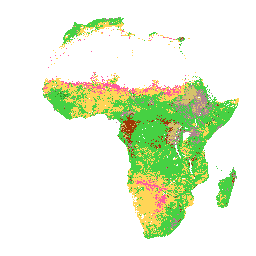
土壤深度为 0-20 厘米和 20-50 厘米时的美国农业部土壤质地类别。在茂密丛林地区(通常位于非洲中部),模型准确度较低,因此可能会看到条带状伪影。
土壤属性预测由 Innovative Solutions for Decision Agriculture Ltd. (iSDA) 使用机器学习与遥感数据以及超过 10 万个已分析土壤样本的训练集相结合,以 30 米像素大小进行。
如需了解详情,请参阅常见问题解答和技术信息文档。如需提交问题或请求支持,请访问 iSDAsoil 网站。
频段
波段
像素大小:30 米(所有波段)
| 名称 | 像元大小 | 说明 |
|---|---|---|
texture_0_20 |
30 米 | 0-20 厘米深度的美国农业部质地类别 |
texture_20_50 |
30 米 | 20-50 厘米深度的美国农业部土壤质地类别 |
texture_0_20 类别表
| 值 | 颜色 | 说明 |
|---|---|---|
| 1 | #d5c36b | 泥塑 |
| 2 | #b96947 | 粉质黏土 |
| 3 | #9d3706 | 沙质黏土 |
| 4 | #ae868f | 黏壤土 |
| 5 | #f86714 | 粉质黏壤土 |
| 6 | #46d143 | 砂质黏壤土 |
| 7 | #368f20 | 壤土 |
| 8 | #3e5a14 | 壤土 |
| 9 | #ffd557 | 砂壤土 |
| 10 | #fff72e | Silt |
| 11 | #ff5a9d | 壤质沙土 |
| 12 | #ff005b | 沙子 |
texture_20_50 类别表
| 值 | 颜色 | 说明 |
|---|---|---|
| 1 | #d5c36b | 泥塑 |
| 2 | #b96947 | 粉质黏土 |
| 3 | #9d3706 | 沙质黏土 |
| 4 | #ae868f | 黏壤土 |
| 5 | #f86714 | 粉质黏壤土 |
| 6 | #46d143 | 砂质黏壤土 |
| 7 | #368f20 | 壤土 |
| 8 | #3e5a14 | 壤土 |
| 9 | #ffd557 | 砂壤土 |
| 10 | #fff72e | Silt |
| 11 | #ff5a9d | 壤质沙土 |
| 12 | #ff005b | 沙子 |
使用条款
使用条款
引用
引用:
Hengl, T.、Miller, M.A.E.、Križan, J. 等人。使用双尺度集成机器学习技术,以 30 米的空间分辨率绘制非洲土壤属性和养分地图。Sci Rep 11, 6130 (2021). doi:10.1038/s41598-021-85639-y
通过 Earth Engine 探索
代码编辑器 (JavaScript)
var raw = ee.Image("ISDASOIL/Africa/v1/texture_class");
Map.addLayer(
    raw.select(0), {}, "Texture class, 0-20 cm");
Map.addLayer(
    raw.select(1), {}, "Texture class, 20-50 cm");

Map.setCenter(25, -3, 2);