Page Summary
-
This dataset, providing global river flood hazard maps with water depth information for various return periods, has been superseded by a newer version.
-
The maps cover the world except for Greenland, Antarctica, and small islands with river basins under 500 km².
-
The data is generated using the LISFLOOD hydrological and LISFLOOD-FP hydrodynamic models as part of the Copernicus Emergency Management Service.
-
The dataset includes a 'depth' band representing flood inundation depth and image properties like 'return_period' and 'id'.
-
JRC datasets, including this one, are available without restriction on use or distribution.
- Dataset Availability
- 2024-03-16T00:00:00Z–2024-03-16T23:59:59Z
- Dataset Provider
- Joint Research Centre
- Tags
Description
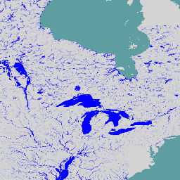
The global river flood hazard maps are a gridded data set representing inundation along the river network, for seven different flood return periods (from 1-in-10-years to 1-in-500-years). The input river flow data for the new maps are produced by means of the open-source hydrological model LISFLOOD, while inundation simulations are performed with the hydrodynamic model LISFLOOD-FP. The extent comprises the entire world with the exception of Greenland and Antarctica and small islands with river basins smaller than 500 km^2.
Cell values indicate water depth (in meters). The maps can be used to assess the exposure of population and economic assets to river floods, and to perform flood risk assessments. The dataset is created as part of the Copernicus Emergency Management Service.
Bands
Pixel Size
90 meters
Bands
| Name | Units | Min | Max | Pixel Size | Description |
|---|---|---|---|---|---|
depth |
m | 0.1 | 9494.89 | meters | Flood inundation depth |
Image Properties
Image Properties
| Name | Type | Description |
|---|---|---|
| return_period | INT | Return period of flood in years. |
| id | INT | Unique identifier for the latitude/longitude grid cell. |
Terms of Use
Terms of Use
The JRC datasets are available without restriction on use or distribution. For more information check access rights,
Citations
Baugh, Calum; Colonese, Juan; D'Angelo, Claudia; Dottori, Francesco; Neal, Jeffrey; Prudhomme, Christel; Salamon, Peter (2024): Global river flood hazard maps. European Commission, Joint Research Centre (JRC) [Dataset] PID: http://data.europa.eu/89h/jrc-floods-floodmapgl_rp50y-tif
DOIs
Explore with Earth Engine
Code Editor (JavaScript)
var dataset = ee.ImageCollection('JRC/CEMS_GLOFAS/FloodHazard/v1');
var depth = dataset.select('depth');
var depthVis = {
  min: 0,
  max: 1,
  palette: ['ffffff','0000ff'],
};
Map.setCenter(-86.47, 47.28, 4);
Map.addLayer(depth, depthVis, 'JRC Flood Hazard Maps');