AI-generated Key Takeaways
-
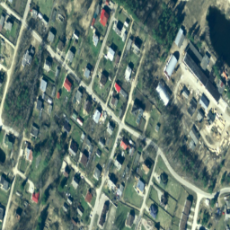
The dataset provides RGB orthophoto maps of Latvia prepared in the LKS-92 TM coordinate system.
-
Orthophoto maps cover the whole territory of Latvia at a scale of 1:10000, with some areas at 1:2000 or 1:1000.
-
The dataset includes red, green, and blue bands with a pixel size of 0.2 meters.
-
Data is available from 2007-01-01 to 2018-01-01 and is provided by the Latvian Geospatial Information Agency.
- Dataset Availability
- 2007-01-01T00:00:00Z–2018-01-01T00:00:00Z
- Dataset Provider
- Latvia orthophotos
- Tags
Description
In Latvia, orthophoto maps are prepared in the Latvian coordinate system LKS-92 TM according to the TKS-93 map sheet division (scale 1:10000 map sheet corresponds to 5 x 5 kilometers in nature). Orthophoto maps are prepared for the whole territory of Latvia at the scale of 1:10000, but for separate territories - for cities and densely populated areas - at the scale of 1:2000 or 1:1000.
The RGB dataset has three bands: red, green, and blue.
For more information, please see the Latvia orthophotos documentation
Bands
Pixel Size
0.2 meters
Bands
| Name | Units | Min | Max | Pixel Size | Description |
|---|---|---|---|---|---|
R |
dn | 0 | 255 | meters | Red |
G |
dn | 0 | 255 | meters | Green |
B |
dn | 0 | 255 | meters | Blue |
Terms of Use
Terms of Use
For more details please see the Terms of use
Citations
Latvijas Geospatial Information Agency
Explore with Earth Engine
Code Editor (JavaScript)
var dataset = ee.ImageCollection('Latvia/Maamet/orthos/rgb');

Map.setCenter(24.737, 56.861, 15);
Map.addLayer(dataset, null, 'Latvia Maamet RGB');