- 数据集可用时间
- 2000-02-24T00:00:00Z–2022-11-15T00:00:00Z
- 数据集生产者
- 美国地质调查局地球资源观测与科学中心下属的美国国家航空航天局陆地过程分布式主动存档中心
- 时间分辨率
- 1 天
- 标签
说明
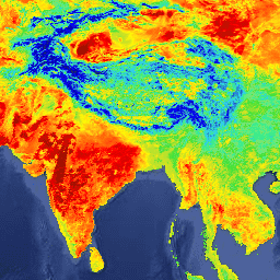
MOD11A1 V6 产品以 1200 x 1200 公里的网格提供每日地表温度 (LST) 和发射率值。温度值源自 MOD11_L2 幅宽产品。在 30 度纬度以上,部分像素可能有多项满足晴空条件的观测结果。如果出现这种情况,像素值将是所有符合条件的观测值的平均值。除了白天和夜间地表温度波段及其质量指标层之外,还提供 MODIS 波段 31 和 32 以及六个观测层。
文档:
频段
像素大小
1000 米
波段
| 名称 | 单位 | 最小值 | 最大值 | 缩放 | 偏移值 | 像素大小 | 说明 | ||||||||||||||||||||||||||||||||||||||||||||||||||||||||||||||||||||||||||||||||||||||||||||
|---|---|---|---|---|---|---|---|---|---|---|---|---|---|---|---|---|---|---|---|---|---|---|---|---|---|---|---|---|---|---|---|---|---|---|---|---|---|---|---|---|---|---|---|---|---|---|---|---|---|---|---|---|---|---|---|---|---|---|---|---|---|---|---|---|---|---|---|---|---|---|---|---|---|---|---|---|---|---|---|---|---|---|---|---|---|---|---|---|---|---|---|---|---|---|---|---|---|---|---|
LST_Day_1km |
K | 7500 | 65535 | 0.02 | 米 | 白天地表温度 |
|||||||||||||||||||||||||||||||||||||||||||||||||||||||||||||||||||||||||||||||||||||||||||||
QC_Day |
米 | 白天 LST 质量指标 |
|||||||||||||||||||||||||||||||||||||||||||||||||||||||||||||||||||||||||||||||||||||||||||||||||
Day_view_time |
小时 | 0 | 240 | 0.1 | 米 | 当地时段观测 |
|||||||||||||||||||||||||||||||||||||||||||||||||||||||||||||||||||||||||||||||||||||||||||||
Day_view_angle |
度 | 0 | 130 | -65 | 米 | 查看白天观测的太阳天顶角 |
|||||||||||||||||||||||||||||||||||||||||||||||||||||||||||||||||||||||||||||||||||||||||||||
LST_Night_1km |
K | 7500 | 65535 | 0.02 | 米 | 夜间地表温度 |
|||||||||||||||||||||||||||||||||||||||||||||||||||||||||||||||||||||||||||||||||||||||||||||
QC_Night |
米 | 夜间 LST 质量指标 |
|||||||||||||||||||||||||||||||||||||||||||||||||||||||||||||||||||||||||||||||||||||||||||||||||
Night_view_time |
小时 | 0 | 240 | 0.1 | 米 | 夜间观测的当地时间 |
|||||||||||||||||||||||||||||||||||||||||||||||||||||||||||||||||||||||||||||||||||||||||||||
Night_view_angle |
度 | 0 | 130 | -65 | 米 | 查看夜间观测的天顶角 |
|||||||||||||||||||||||||||||||||||||||||||||||||||||||||||||||||||||||||||||||||||||||||||||
Emis_31 |
1 | 255 | 0.002 | 0.49 | 米 | 波段 31 的发射率 |
|||||||||||||||||||||||||||||||||||||||||||||||||||||||||||||||||||||||||||||||||||||||||||||
Emis_32 |
1 | 255 | 0.002 | 0.49 | 米 | 波段 32 发射率 |
|||||||||||||||||||||||||||||||||||||||||||||||||||||||||||||||||||||||||||||||||||||||||||||
Clear_day_cov |
1 | 65535 | 0.0005 | 米 | 白天晴空覆盖率 |
||||||||||||||||||||||||||||||||||||||||||||||||||||||||||||||||||||||||||||||||||||||||||||||
Clear_night_cov |
1 | 65535 | 0.0005 | 米 | 夜间晴空覆盖率 |
||||||||||||||||||||||||||||||||||||||||||||||||||||||||||||||||||||||||||||||||||||||||||||||
使用条款
使用条款
通过 LP DAAC 获取的 MODIS 数据和产品在后续使用、销售或再分发方面没有任何限制。
引用
引用:
如需了解如何引用 LP DAAC 数据集,请访问 LP DAAC 的“引用我们的数据”页面。
DOI
通过 Earth Engine 探索
代码编辑器 (JavaScript)
var dataset = ee.ImageCollection('MODIS/006/MOD11A1')
                  .filter(ee.Filter.date('2018-01-01', '2018-05-01'));
var landSurfaceTemperature = dataset.select('LST_Day_1km');
var landSurfaceTemperatureVis = {
  min: 13000,
  max: 16500,
  palette: [
    '040274', '040281', '0502a3', '0502b8', '0502ce', '0502e6',
    '0602ff', '235cb1', '307ef3', '269db1', '30c8e2', '32d3ef',
    '3be285', '3ff38f', '86e26f', '3ae237', 'b5e22e', 'd6e21f',
    'fff705', 'ffd611', 'ffb613', 'ff8b13', 'ff6e08', 'ff500d',
    'ff0000', 'de0101', 'c21301', 'a71001', '911003'
  ],
};
Map.setCenter(6.746, 46.529, 2);
Map.addLayer(
    landSurfaceTemperature, landSurfaceTemperatureVis,
    'Land Surface Temperature');