- 数据集可用时间
- 2001-01-01T00:00:00Z–2024-01-01T00:00:00Z
- 数据集生产者
- 美国地质调查局地球资源观测与科学中心下属的美国国家航空航天局陆地过程分布式主动存档中心
- 频率
- 1 年
- 标签
说明
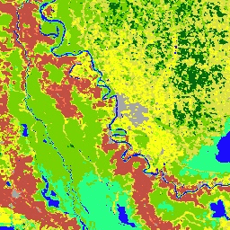
Terra 和 Aqua 组合中等分辨率成像光谱辐射计 (MODIS) 土地覆盖类型 (MCD12Q1) 版本 6.1 数据产品以年为间隔提供全球土地覆盖类型。MCD12Q1 版本 6.1 数据产品是使用 MODIS Terra 和 Aqua 反射率数据的监督分类得出的。地表覆盖类型源自国际地圈-生物圈计划 (IGBP)、马里兰大学 (UMD)、叶面积指数 (LAI)、BIOME-Biogeochemical Cycles (BGC) 和植物功能类型 (PFT) 分类方案。然后,监督分类会进行额外的后处理,纳入先验知识和辅助信息,以进一步细化特定类别。联合国粮食及农业组织 (FAO) 土地覆盖分类系统 (LCCS) 还提供了其他土地覆盖属性评估层,用于评估土地覆盖、土地利用和地表水文。
此外,还提供土地覆盖类型 1-5、土地覆盖属性 1-3、土地覆盖属性评估 1-3、土地覆盖质量控制 (QC) 和陆地水体掩码的图层。
文档:
频段
波段
像素大小:500 米(所有波段)
| 名称 | 单位 | 最小值 | 最大值 | 像素大小 | 说明 |
|---|---|---|---|---|---|
LC_Type1 |
500 米 | 土地覆盖类型 1:年度国际地圈-生物圈计划 (IGBP) 分类 |
|||
LC_Type2 |
500 米 | 土地覆盖类型 2:马里兰大学 (UMD) 年度分类 |
|||
LC_Type3 |
500 米 | 土地覆盖类型 3:年叶面积指数 (LAI) 分类 |
|||
LC_Type4 |
500 米 | 土地覆盖类型 4:年度 BIOME-Biogeochemical Cycles (BGC) 分类 |
|||
LC_Type5 |
500 米 | 土地覆盖类型 5:一年生植物功能类型分类 |
|||
LC_Prop1_Assessment |
% | 0 | 100 | 500 米 | LCCS1 土地覆盖层置信度 |
LC_Prop2_Assessment |
% | 0 | 100 | 500 米 | LCCS2 土地利用层置信度 |
LC_Prop3_Assessment |
% | 0 | 100 | 500 米 | LCCS3 表面水文层置信度 |
LC_Prop1 |
500 米 | FAO-土地覆盖分类系统 1 (LCCS1) 土地覆盖层 |
|||
LC_Prop2 |
500 米 | FAO-LCCS2 土地用途层 |
|||
LC_Prop3 |
500 米 | FAO-LCCS3 地表水文层 |
|||
QC |
500 米 | 商品质量标志 |
|||
LW |
500 米 | 根据 MOD44W 得出的二元陆地(类别 2)/水体(类别 1)掩码 |
LC_Type1 类别表
| 值 | 颜色 | 说明 |
|---|---|---|
| 1 | #05450a | 常绿针叶林:以常绿针叶乔木为主(树冠 >2 米)。树木覆盖率 >60%。 |
| 2 | #086a10 | 常绿阔叶林:以常绿阔叶树和掌状树为主(树冠 >2 米)。树木覆盖率 >60%。 |
| 3 | #54a708 | 落叶针叶林:以落叶针叶树(落叶松)为主(树冠 >2 米)。树木覆盖率 >60%。 |
| 4 | #78d203 | 落叶阔叶林:以落叶阔叶树为主(树冠 >2 米)。树木覆盖率 >60%。 |
| 5 | #009900 | 混交林:以落叶树或常绿树为主(每种树的比例为 40-60%)(树冠 >2 米)。树木覆盖率 >60%。 |
| 6 | #c6b044 | 密灌丛:以木本多年生植物(高度 1-2 米)为主,覆盖率 >60%。 |
| 7 | #dcd159 | 开阔的灌木丛:以木本多年生植物(高度 1-2 米)为主,覆盖率 10-60%。 |
| 8 | #dade48 | 木质稀树草原:树木覆盖率 30-60%(树冠 >2 米)。 |
| 9 | #fbff13 | 热带草原:树木覆盖率 10-30%(树冠 >2 米)。 |
| 10 | #b6ff05 | 草原:以草本一年生植物(高度 <2 米)为主。 |
| 11 | #27ff87 | 永久性湿地:永久性淹没的土地,水面覆盖率 30-60%,植被覆盖率 >10%。 |
| 12 | #c24f44 | 耕地。 |
| 13 | #a5a5a5 | 城市和建成区:至少 30% 的不透水表面积,包括建筑材料、沥青和车辆。 |
| 14 | #ff6d4c | 农田/天然植被镶嵌:小规模耕作占 40-60% 的镶嵌,其余为天然树木、灌木或草本植被。 |
| 15 | #69fff8 | 永久性冰雪:至少 60% 的区域全年至少有 10 个月被冰雪覆盖。 |
| 16 | #f9ffa4 | 植被覆盖率低于 10% 的区域(沙地、岩石地、土壤地)。 |
| 17 | #1c0dff | 水体:至少 60% 的面积被永久性水体覆盖。 |
LC_Type2 类表
| 值 | 颜色 | 说明 |
|---|---|---|
| 0 | #1c0dff | 水体:至少 60% 的面积被永久性水体覆盖。 |
| 1 | #05450a | 常绿针叶林:以常绿针叶乔木为主(树冠 >2 米)。树木覆盖率 >60%。 |
| 2 | #086a10 | 常绿阔叶林:以常绿阔叶树和掌状树为主(树冠 >2 米)。树木覆盖率 >60%。 |
| 3 | #54a708 | 落叶针叶林:以落叶针叶树(落叶松)为主(树冠 >2 米)。树木覆盖率 >60%。 |
| 4 | #78d203 | 落叶阔叶林:以落叶阔叶树为主(树冠 >2 米)。树木覆盖率 >60%。 |
| 5 | #009900 | 混交林:以落叶树或常绿树为主(每种树的比例为 40-60%)(树冠 >2 米)。树木覆盖率 >60%。 |
| 6 | #c6b044 | 密灌丛:以木本多年生植物(高度 1-2 米)为主,覆盖率 >60%。 |
| 7 | #dcd159 | 开阔的灌木丛:以木本多年生植物(高度 1-2 米)为主,覆盖率 10-60%。 |
| 8 | #dade48 | 木质稀树草原:树木覆盖率 30-60%(树冠 >2 米)。 |
| 9 | #fbff13 | 热带草原:树木覆盖率 10-30%(树冠 >2 米)。 |
| 10 | #b6ff05 | 草原:以草本一年生植物(高度 <2 米)为主。 |
| 11 | #27ff87 | 永久性湿地:永久性淹没的土地,水面覆盖率 30-60%,植被覆盖率 >10%。 |
| 12 | #c24f44 | 耕地。 |
| 13 | #a5a5a5 | 城市和建成区:至少 30% 的不透水表面积,包括建筑材料、沥青和车辆。 |
| 14 | #ff6d4c | 农田/天然植被镶嵌:小规模耕作占 40-60% 的镶嵌,其余为天然树木、灌木或草本植被。 |
| 15 | #f9ffa4 | 无植被土地:至少 60% 的面积为无植被的贫瘠土地(沙地、岩石、土壤)或永久性冰雪,植被覆盖率低于 10%。 |
LC_Type3 类别表
| 值 | 颜色 | 说明 |
|---|---|---|
| 0 | #1c0dff | 水体:至少 60% 的面积被永久性水体覆盖。 |
| 1 | #b6ff05 | 草地:以草本一年生植物(<2 米)为主,包括谷类农田。 |
| 2 | #dcd159 | 灌丛地:灌木(1-2 米)覆盖率 >10%。 |
| 3 | #c24f44 | 阔叶农田:以与阔叶作物一起种植的草本一年生植物(<2 米)为主。 |
| 4 | #fbff13 | 热带草原:树木覆盖率介于 10% 到 60% 之间(高于 2 米)。 |
| 5 | #086a10 | 常绿阔叶林:以常绿阔叶树和掌状树为主(树冠 >2 米)。树木覆盖率 >60%。 |
| 6 | #78d203 | 落叶阔叶林:以落叶阔叶树为主(树冠 >2 米)。树木覆盖率 >60%。 |
| 7 | #05450a | 常绿针叶林:以常绿针叶乔木为主(树冠 >2 米)。树木覆盖率 >60%。 |
| 8 | #54a708 | 落叶针叶林:以落叶针叶树(落叶松)为主(树冠 >2 米)。树木覆盖率 >60%。 |
| 9 | #f9ffa4 | 无植被土地:至少 60% 的面积为无植被的贫瘠土地(沙地、岩石、土壤)或永久性冰雪,植被覆盖率低于 10%。 |
| 10 | #a5a5a5 | 城市和建成区:至少 30% 的不透水表面积,包括建筑材料、沥青和车辆。 |
LC_Type4 类表
| 值 | 颜色 | 说明 |
|---|---|---|
| 0 | #1c0dff | 水体:至少 60% 的面积被永久性水体覆盖。 |
| 1 | #05450a | 常绿针叶植被:以常绿针叶乔木和灌木(高于 1 米)为主。木本植被覆盖率 >10%。 |
| 2 | #086a10 | 常绿阔叶植被:以常绿阔叶和掌状树木和灌木(>1 米)为主。木本植被覆盖率
|
| 3 | #54a708 | 落叶针叶植被:以落叶针叶(落叶松)乔木和灌木(>1 米)为主。木本植被覆盖率
|
| 4 | #78d203 | 落叶阔叶植被:以落叶阔叶乔木和灌木(>1 米)为主。木本植被覆盖率 >10%。 |
| 5 | #009900 | 一年生阔叶植被:以草本一年生植物(<2 米)为主。至少 60% 的栽培阔叶作物。 |
| 6 | #b6ff05 | 一年生草本植被:以草本一年生植物(<2 米)为主,包括谷物农田。 |
| 7 | #f9ffa4 | 无植被土地:至少 60% 的面积为无植被的贫瘠土地(沙地、岩石、土壤)或永久性积雪/冰,植被覆盖率低于 10%。 |
| 8 | #a5a5a5 | 城市和建成区:至少 30% 的不透水表面积,包括建筑材料、沥青和车辆。 |
LC_Type5 类表
| 值 | 颜色 | 说明 |
|---|---|---|
| 0 | #1c0dff | 水体:至少 60% 的面积被永久性水体覆盖。 |
| 1 | #05450a | 常绿针叶树:以常绿针叶树(>2 米)为主。树木覆盖率 >10%。 |
| 2 | #086a10 | 常绿阔叶树:以常绿阔叶树和掌状树(高度 >2 米)为主。树木覆盖率 >10%。 |
| 3 | #54a708 | 落叶针叶树:以落叶针叶树(落叶松)为主(>2 米)。树木覆盖率 >10%。 |
| 4 | #78d203 | 落叶阔叶树:以落叶阔叶树(高度 >2 米)为主。树木覆盖率 >10%。 |
| 5 | #dcd159 | 灌木:灌木(1-2 米)覆盖率 >10%。 |
| 6 | #b6ff05 | 未种植。 |
| 7 | #dade48 | 谷物耕地:以草本一年生植物(<2 米)为主。至少 60% 的耕种谷物作物。 |
| 8 | #c24f44 | 阔叶农田:以草本一年生植物(<2 米)为主。至少 60% 的栽培阔叶作物。 |
| 9 | #a5a5a5 | 城市和建成区:至少 30% 的不透水表面积,包括建筑材料、沥青和车辆。 |
| 10 | #69fff8 | 永久性冰雪:至少 60% 的区域全年至少有 10 个月被冰雪覆盖。 |
| 11 | #f9ffa4 | 无植被土地:至少 60% 的面积为无植被的贫瘠土地(沙地、岩石地、土壤),植被覆盖率低于 10%。 |
LC_Prop1 类别表
| 值 | 颜色 | 说明 |
|---|---|---|
| 1 | #f9ffa4 | (沙地、岩石、土壤)或永久性积雪/冰,植被覆盖率低于 10%。 |
| 2 | #69fff8 | 永久性冰雪:至少 60% 的区域全年至少有 10 个月被冰雪覆盖。 |
| 3 | #1c0dff | 水体:至少 60% 的面积被永久性水体覆盖。 |
| 11 | #05450a | 常绿针叶林:以常绿针叶树(高于 2 米)为主。树木覆盖率 >60%。 |
| 12 | #086a10 | 常绿阔叶林:以常绿阔叶树和掌状树(高度 >2 米)为主。树木覆盖率 >60%。 |
| 13 | #54a708 | 落叶针叶林:以落叶针叶树(落叶松)为主(高度 >2 米)。树木覆盖率 >60%。 |
| 14 | #78d203 | 落叶阔叶林:以落叶阔叶树(>2 米)为主。树木覆盖率 >60%。 |
| 15 | #005a00 | 阔叶/针叶混交林:以阔叶落叶树和常绿针叶树(高度超过 2 米)为主(占 40-60%)。树木覆盖率 >60%。 |
| 16 | #009900 | 阔叶常绿/落叶混交林:阔叶常绿树和落叶树(高度 >2 米)共同占主导地位(40-60%)。树木覆盖率 >60%。 |
| 21 | #006c00 | 疏林:树木覆盖率 30-60%(树冠 >2 米)。 |
| 22 | #00d000 | 稀疏森林:树木覆盖率 10-30%(树冠 >2 米)。 |
| 31 | #b6ff05 | 茂密的草本植被:以草本一年生植物(<2 米)为主,覆盖率至少为 60%。 |
| 32 | #98d604 | 稀疏草本:以草本一年生植物(<2 米)为主,覆盖率为 10-60%。 |
| 41 | #dcd159 | 茂密的灌木丛:以木本多年生植物(1-2 米)为主
|
| 42 | #f1fb58 | 灌丛/草地镶嵌:以木本多年生植物(1-2 米)为主,覆盖率为 10-60%,下层植被为茂密的草本一年生植物。 |
| 43 | #fbee65 | 稀疏灌木丛:以木本多年生植物(1-2 米)为主,覆盖率 10-60%,草本下层植被极少。 |
LC_Prop2 类别表
| 值 | 颜色 | 说明 |
|---|---|---|
| 1 | #f9ffa4 | (沙地、岩石、土壤)或永久性积雪/冰,植被覆盖率低于 10%。 |
| 2 | #69fff8 | 永久性冰雪:至少 60% 的区域全年至少有 10 个月被冰雪覆盖。 |
| 3 | #1c0dff | 水体:至少 60% 的面积被永久性水体覆盖。 |
| 9 | #a5a5a5 | 城市和建成区:至少 30% 的面积由不透水表面组成,包括建筑材料、沥青和车辆。 |
| 10 | #003f00 | 茂密的森林:树木覆盖率 >60%(树冠 >2 米)。 |
| 20 | #006c00 | 疏林:树木覆盖率 10-60%(树冠 >2 米)。 |
| 25 | #e3ff77 | 森林/农田镶嵌:小规模耕作占 40-60%,天然树木覆盖率 >10% 的镶嵌地块。 |
| 30 | #b6ff05 | 天然草本:以草本一年生植物(<2 米)为主。至少 10% 的覆盖率。 |
| 35 | #93ce04 | 天然草本/农田镶嵌:小规模耕作占 40-60%,其余为天然灌木或草本植被。 |
| 36 | #77a703 | 草本耕地:以草本一年生植物(<2 米)为主。至少 60% 的覆盖率。培育比例 >60%。 |
| 40 | #dcd159 | 灌丛:灌木覆盖率 >60%(1-2 米)。 |
LC_Prop3 类表
| 值 | 颜色 | 说明 |
|---|---|---|
| 1 | #f9ffa4 | (沙地、岩石、土壤)或永久性积雪/冰,植被覆盖率低于 10%。 |
| 2 | #69fff8 | 永久性冰雪:至少 60% 的区域全年至少有 10 个月被冰雪覆盖。 |
| 3 | #1c0dff | 水体:至少 60% 的面积被永久性水体覆盖。 |
| 10 | #003f00 | 茂密的森林:树木覆盖率 >60%(树冠 >2 米)。 |
| 20 | #006c00 | 疏林:树木覆盖率 10-60%(树冠 >2 米)。 |
| 27 | #72834a | 木本湿地:灌木和树木覆盖率 >10%(>1 米)。 永久性或季节性淹没。 |
| 30 | #b6ff05 | 草地:以草本一年生植物(高度 <2 米)为主,覆盖率 >10%。 |
| 40 | #c6b044 | 灌丛:灌木覆盖率 >60%(1-2 米)。 |
| 50 | #3aba73 | 草本湿地:以草本一年生植物(<2 米)为主,覆盖率 >10%。永久性或季节性淹没。 |
| 51 | #1e9db3 | 月份。 |
QC 类别表
| 值 | 颜色 | 说明 |
|---|---|---|
| 0 | 无 | 已分类的陆地:具有分类标签,并且根据水掩膜是陆地。 |
| 1 | 无 | 未分类的陆地:由于缺少数据而未分类,但根据水掩膜是陆地,标记为贫瘠。 |
| 2 | 无 | 已分类的水:具有分类标签,并且根据水掩码是水。 |
| 3 | 无 | 未分类的水:由于缺少数据而未分类,但根据水掩码,属于水。 |
| 4 | 无 | 归类为海冰:归类为雪/冰,但水掩码显示为水且海拔低于 100 米,因此切换为水。 |
| 5 | 无 | 错误分类的水:被分类为水,但水掩码显示为陆地,已切换到次要标签。 |
| 6 | 无 | 省略的雪/冰:根据水掩码被归类为雪以外的其他物质但年最高温度低于 1°C 的陆地,重新标记为雪/冰。 |
| 7 | 无 | 错误分类的雪/冰:根据水掩膜被分类为雪但年最低气温高于 1°C 的陆地,重新标记为贫瘠。 |
| 8 | 无 | 回填标签:稳定化后缺失的标签,用稳定化前的结果填充。 |
| 9 | 无 | 森林类型已更改:基于气候的森林类别更改。 |
LW 类别表
| 值 | 颜色 | 说明 |
|---|---|---|
| 1 | #1c0dff | 水 |
| 2 | #f9ffa4 | 陆地, |
使用条款
使用条款
通过 LP DAAC 获取的 MODIS 数据和产品在后续使用、销售或再分发方面没有任何限制。
引用
如需了解如何引用 LP DAAC 数据集,请访问 LP DAAC 的“引用我们的数据”页面。
DOI
通过 Earth Engine 探索
代码编辑器 (JavaScript)
var dataset = ee.ImageCollection('MODIS/061/MCD12Q1');
var igbpLandCover = dataset.select('LC_Type1');
var igbpLandCoverVis = {
  min: 1.0,
  max: 17.0,
  palette: [
    '05450a', '086a10', '54a708', '78d203', '009900', 'c6b044', 'dcd159',
    'dade48', 'fbff13', 'b6ff05', '27ff87', 'c24f44', 'a5a5a5', 'ff6d4c',
    '69fff8', 'f9ffa4', '1c0dff'
  ],
};
Map.setCenter(6.746, 46.529, 6);
Map.addLayer(igbpLandCover, igbpLandCoverVis, 'IGBP Land Cover');
import ee
import geemap.core as geemap
Colab (Python)
dataset = ee.ImageCollection('MODIS/061/MCD12Q1')

igbp_land_cover = dataset.select('LC_Type1')

igbp_land_cover_vis = {
    'min': 1.0,
    'max': 17.0,
    'palette': [
        '05450a', '086a10', '54a708', '78d203', '009900', 'c6b044', 'dcd159',
        'dade48', 'fbff13', 'b6ff05', '27ff87', 'c24f44', 'a5a5a5', 'ff6d4c',
        '69fff8', 'f9ffa4', '1c0dff'
    ],
}

m = geemap.Map()
m.set_center(6.746, 46.529, 6)
m.add_layer(igbp_land_cover, igbp_land_cover_vis, 'IGBP Land Cover')
m