Page Summary
-
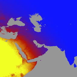
The MCD18A1 Version 6.2 product provides daily, 1-kilometer resolution estimates of Downward Shortwave Radiation (DSR) every 3 hours.
-
DSR is incident solar radiation in the shortwave spectrum over land surfaces and is important for land-surface models.
-
The product is based on an algorithm that uses multi-temporal MODIS data signatures and a look-up table approach to calculate DSR.
-
Bands include instantaneous total, direct, and diffuse DSR at MODIS overpass, as well as total DSR every 3 hours GMT.
-
MODIS data and products have no restrictions on subsequent use, sale, or redistribution.
- Dataset Availability
- 2000-03-03T00:00:00Z–2026-06-01T00:00:00Z
- Dataset Producer
- NASA LP DAAC at the USGS EROS Center
- Cadence
- 1 Day
- Tags
Description
The MCD18A1 Version 6.2 is a Moderate Resolution Imaging Spectroradiometer (MODIS) Terra and Aqua combined Downward Shortwave Radiation (DSR) gridded Level 3 product produced daily at 1 kilometer pixel resolution with estimates of DSR every 3 hours. DSR is incident solar radiation over land surfaces in the shortwave spectrum (300-4,000 nanometers) and is an important variable in land-surface models that address a variety of scientific and application issues. The MCD18 products are based on a prototyping algorithm that uses multi-temporal signatures of MODIS data to derive surface reflectance and then calculate incident DSR using the look-up table (LUT) approach. The LUTs consider different types of loadings of aerosols and clouds at a variety of illumination/viewing geometry. Global DSR products are generated from MODIS and geostationary satellite data. Additional details regarding the methodology used to create the data are available in the Algorithm Theoretical Basis Document.
Bands
Bands
Pixel size: 1000 meters (all bands)
| Name | Units | Min | Max | Pixel Size | Description | ||||||||||||||||||||||||||||||||||||||||||||||||||||||||||||||||||||||||||||||||||||||||||||||
|---|---|---|---|---|---|---|---|---|---|---|---|---|---|---|---|---|---|---|---|---|---|---|---|---|---|---|---|---|---|---|---|---|---|---|---|---|---|---|---|---|---|---|---|---|---|---|---|---|---|---|---|---|---|---|---|---|---|---|---|---|---|---|---|---|---|---|---|---|---|---|---|---|---|---|---|---|---|---|---|---|---|---|---|---|---|---|---|---|---|---|---|---|---|---|---|---|---|---|---|
DSR |
W/m^2 | 0 | 1400 | 1000 meters | Instantaneous total DSR at MODIS overpass |
||||||||||||||||||||||||||||||||||||||||||||||||||||||||||||||||||||||||||||||||||||||||||||||
Direct |
W/m^2 | 0 | 1400 | 1000 meters | Instantaneous direct DSR at MODIS overpass |
||||||||||||||||||||||||||||||||||||||||||||||||||||||||||||||||||||||||||||||||||||||||||||||
Diffuse |
W/m^2 | 0 | 1400 | 1000 meters | Instantaneous diffuse DSR at MODIS overpass |
||||||||||||||||||||||||||||||||||||||||||||||||||||||||||||||||||||||||||||||||||||||||||||||
GMT_0000_DSR |
W/m^2 | 0 | 1400 | 1000 meters | Total DSR at GMT 00:00 |
||||||||||||||||||||||||||||||||||||||||||||||||||||||||||||||||||||||||||||||||||||||||||||||
GMT_0300_DSR |
W/m^2 | 0 | 1400 | 1000 meters | Total DSR at GMT 03:00 |
||||||||||||||||||||||||||||||||||||||||||||||||||||||||||||||||||||||||||||||||||||||||||||||
GMT_0600_DSR |
W/m^2 | 0 | 1400 | 1000 meters | Total DSR at GMT 06:00 |
||||||||||||||||||||||||||||||||||||||||||||||||||||||||||||||||||||||||||||||||||||||||||||||
GMT_0900_DSR |
W/m^2 | 0 | 1400 | 1000 meters | Total DSR at GMT 09:00 |
||||||||||||||||||||||||||||||||||||||||||||||||||||||||||||||||||||||||||||||||||||||||||||||
GMT_1200_DSR |
W/m^2 | 0 | 1400 | 1000 meters | Total DSR at GMT 12:00 |
||||||||||||||||||||||||||||||||||||||||||||||||||||||||||||||||||||||||||||||||||||||||||||||
GMT_1500_DSR |
W/m^2 | 0 | 1400 | 1000 meters | Total DSR at GMT 15:00 |
||||||||||||||||||||||||||||||||||||||||||||||||||||||||||||||||||||||||||||||||||||||||||||||
GMT_1800_DSR |
W/m^2 | 0 | 1400 | 1000 meters | Total DSR at GMT 18:00 |
||||||||||||||||||||||||||||||||||||||||||||||||||||||||||||||||||||||||||||||||||||||||||||||
GMT_2100_DSR |
W/m^2 | 0 | 1400 | 1000 meters | Total DSR at GMT 21:00 |
||||||||||||||||||||||||||||||||||||||||||||||||||||||||||||||||||||||||||||||||||||||||||||||
DSR_Quality |
1000 meters | Quality flag |
|||||||||||||||||||||||||||||||||||||||||||||||||||||||||||||||||||||||||||||||||||||||||||||||||
Terms of Use
Terms of Use
MODIS data and products acquired through the LP DAAC have no restrictions on subsequent use, sale, or redistribution.
Citations
Please visit LP DAAC 'Citing Our Data' page for information on citing LP DAAC datasets.
DOIs
Explore with Earth Engine
Code Editor (JavaScript)
var dataset = ee.ImageCollection('MODIS/062/MCD18A1')
                  .filter(ee.Filter.date('2000-01-01', '2001-01-01'));
var gmt_1200_dsr = dataset.select('GMT_1200_DSR');
var gmt_1200_dsr_vis = {
  min: 0,
  max: 350,
  palette: ['0f17ff', 'b11406', 'f1ff23'],
};
Map.setCenter(6.746, 46.529, 2);
Map.addLayer(
    gmt_1200_dsr, gmt_1200_dsr_vis,
    'Total dsr at GMT 12:00');