Page Summary
-
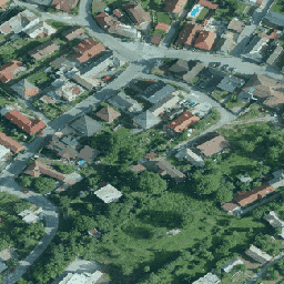
The Orthophotomosaic of the Slovak Republic is a set of color orthoimages available from 2017 to 2020.
-
This dataset provides R, G, and B bands with a pixel size of 0.25 meters.
-
Users can combine and publish the data for commercial and non-commercial purposes, provided they cite the author as "GKÚ Bratislava, NLC".
-
The dataset can be explored using the Google Earth Engine platform.
- Dataset Availability
- 2017-01-01T00:00:00Z–2020-01-01T00:00:00Z
- Dataset Provider
- Slovakia orthophotomosaic
- Tags
Description
Orthophotomosaic of the Slovak Republic is a set of color orthoimages without overlaps, gaps and visible brightness and color differences along the connecting lines.
For more information, please see the Slovakia orthophotos documentation
Bands
Pixel Size
0.25 meters
Bands
| Name | Units | Min | Max | Pixel Size | Description |
|---|---|---|---|---|---|
R |
dn | 0 | 255 | meters | Red |
G |
dn | 0 | 255 | meters | Green |
B |
dn | 0 | 255 | meters | Blue |
Terms of Use
Terms of Use
The User is entitled to combine the Source Data with other data, use it in the creation of his/her own work for commercial and non-commercial purposes, create a new work, publish the work on the Internet, publish the Source Data as a base map, publish the Source Data in connection with other data/thematic layers through web apps. The User is obliged to provide the name of the Author of the Source Data when creating his/her own work and when publishing it as follows: "GKÚ Bratislava, NLC".
For more details, see Terms of use
Citations
GKU Bratislava, NLC
Explore with Earth Engine
Code Editor (JavaScript)
var dataset = ee.ImageCollection('Slovakia/orthos/25cm');

Map.setCenter(19.163, 48.751, 15);
Map.addLayer(dataset, {}, 'Slovakia orthophotos RGB');