- 数据集可用时间
- 2000-02-11T00:00:00Z–2000-02-22T00:00:00Z
- 数据集生产者
- WWF
- 标签
说明
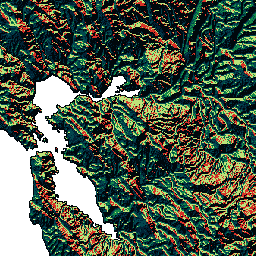
HydroSHEDS 是一种地图产品,可提供水文信息,以一致的格式用于区域和全球范围的应用。它提供了一套不同比例的地理参考数据集(矢量和栅格),包括河流网络、分水岭边界、排水方向和流量累积。HydroSHEDS 基于美国国家航空航天局 (NASA) 的航天飞机雷达地形测绘任务 (SRTM) 于 2000 年获取的海拔数据。
此排水方向数据集定义了从条件 DEM 中的每个单元格到其最陡峭的下坡邻居的流向。排水方向的值介于 1 到 128 之间。所有最终入海口单元格都标记为值 0。所有标记内流盆地(内陆洼地)最低点的单元都标记为值 -1。排水方向值遵循 ESRI 的流向实现所采用的惯例:1=东、2=东南、4=南、8=西南、16=西、32=西北、64=北、128=东北。
此数据集的分辨率为 15 角秒。 以 15 角秒为单位提供的数据集包括水文条件 DEM、排水(流)方向和流量累积。
请注意,对于北纬 60 度以上的区域,HydroSHEDS 数据的质量明显较低,因为没有可用的底层 SRTM 海拔数据,因此使用了分辨率较低的 DEM(USGS 提供的 HYDRO1k)。
HydroSHEDS 由世界自然基金会 (WWF) 的保护科学计划与美国地质调查局、国际热带农业中心、大自然保护协会和德国卡塞尔大学环境系统研究中心合作开发。
频段
波段
像素大小:463.83 米(所有波段)
| 名称 | 最小值 | 最大值 | 像素大小 | 说明 |
|---|---|---|---|---|
b1 |
0* | 255* | 463.83 米 | 排水方向可能的值:1=东、2=东南、4=南、8=西南、16=西、32=西北、64=北、128=东北;最终入海口单元格标记为值 0,而内流盆地(内陆洼地)最低点的单元格标记为值 255(原始值为 -1) |
使用条款
使用条款
HydroSHEDS 数据可免费用于非商业目的和商业用途。如需了解详情,请参阅许可协议。
引用
Lehner, B.,Verdin, K.、Jarvis, A. (2008):New global hydrography derived from spaceborne elevation data. Eos, Transactions, AGU, 89(10): 93-94.
通过 Earth Engine 探索
代码编辑器 (JavaScript)
var dataset = ee.Image('WWF/HydroSHEDS/15DIR');
var drainageDirection = dataset.select('b1');
var drainageDirectionVis = {
  min: 1.0,
  max: 128.0,
  palette: [
    '000000', '023858', '006837', '1a9850', '66bd63', 'a6d96a', 'd9ef8b',
    'ffffbf', 'fee08b', 'fdae61', 'f46d43', 'd73027'
  ],
};
Map.setCenter(-121.652, 38.022, 8);
Map.addLayer(drainageDirection, drainageDirectionVis, 'Drainage Direction');