Nature Trace adalah rangkaian lapisan geospasial yang terus bertambah dari model AI generasi berikutnya yang dikembangkan oleh Google DeepMind dan Google Research untuk memahami lingkungan yang dapat mendukung alam.
-
Farmscapes 2020
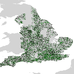
Set data Farmscapes 2020 menyediakan peta probabilitas beresolusi tinggi (25 cm) untuk tiga fitur semi-alami utama dalam lanskap pertanian Inggris: pagar tanaman, hutan, dan dinding batu. Set data ini dikembangkan berkolaborasi dengan Oxford Leverhulme Centre for Nature Recovery untuk berfungsi sebagai dasar bagi aplikasi yang mencakup … biodiversity climate conservation forest landuse-landcover nature-trace -
Hutan Alam Dunia 2020
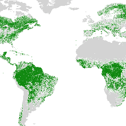
Natural Forests of the World 2020, menyediakan peta global probabilitas hutan alami untuk tahun 2020 pada resolusi 10 meter. Lapisan ini dikembangkan untuk mendukung inisiatif seperti European Union's Deforestation Regulation (EUDR) dan upaya lainnya untuk konservasi dan pemantauan hutan. Peta … keanekaragaman hayati iklim konservasi deforestasi eudr hutan -
Distribusi Spesies, Mamalia Australia

Output model distribusi spesies ini, yang dikembangkan oleh Google bekerja sama dengan QCIF dan EcoCommons, merepresentasikan estimasi kemungkinan kemunculan relatif spesies (yaitu, nilai yang lebih tinggi menunjukkan kemungkinan yang lebih tinggi bahwa spesies akan terdeteksi di suatu lokasi, untuk metodologi survei tertentu dan survei tertentu … biodiversitas konservasi ekosistem nature-trace prapeninjauan publisher-dataset