-
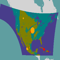
GOES-16 FDCC 系列 ABI 2 级火点/热点特征 CONUS

Fire (HSC) 产品包含四张影像:一张是火点掩膜,另外三张的像素值分别表示火点温度、火点面积和火点辐射功率。ABI L2+ FHS 元数据掩模会为每个经过地球导航定位的像素分配一个标志,用于指示其… abi fdc fire goes goes-16 goes-east -
GOES-16 FDCF 系列 ABI 2 级火点/热点特征全圆盘

Fire (HSC) 产品包含四张影像:一张是火点掩膜,另外三张的像素值分别表示火点温度、火点面积和火点辐射功率。ABI L2+ FHS 元数据掩模会为每个经过地球导航定位的像素分配一个标志,用于指示其… abi fdc fire goes goes-16 goes-east -
GOES-16 MCMIPC 系列 ABI 2 级云和湿气图像 CONUS
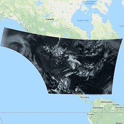
云和湿气图像产品的分辨率均为 2 公里。波段 1-6 为反射性波段。无量纲的“反射因子”量会根据太阳天顶角进行归一化。这些波段支持对云、植被、雪/冰和气溶胶进行表征。波段 7-16 为发射性波段。亮度温度… abi atmosphere goes goes-16 goes-east goes-r -
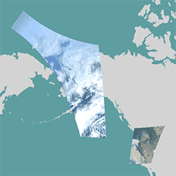
GOES-16 MCMIPF 系列 ABI 2 级云和湿气图像全圆盘

云和湿气图像产品的分辨率均为 2 公里。波段 1-6 为反射性波段。无量纲的“反射因子”量会根据太阳天顶角进行归一化。这些波段支持对云、植被、雪/冰和气溶胶进行表征。波段 7-16 为发射性波段。亮度温度… abi atmosphere goes goes-16 goes-east goes-r -
GOES-16 MCMIPM 系列 ABI 2 级云和湿气图像中尺度
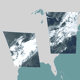
云和湿气图像产品的分辨率均为 2 公里。波段 1-6 为反射性波段。无量纲的“反射因子”量会根据太阳天顶角进行归一化。这些波段支持对云、植被、雪/冰和气溶胶进行表征。波段 7-16 为发射性波段。亮度温度… abi atmosphere goes goes-16 goes-east goes-r -
GOES-17 FDCC 系列 ABI 2 级火点/热点特征 CONUS

Fire (HSC) 产品包含四张影像:一张是火点掩膜,另外三张的像素值分别表示火点温度、火点面积和火点辐射功率。ABI L2+ FHS 元数据掩模会为每个经过地球导航定位的像素分配一个标志,用于指示其… abi fdc fire goes goes-17 goes-s -
GOES-17 FDCF 系列 ABI 2 级火点/热点特征全圆盘

Fire (HSC) 产品包含四张影像:一张是火点掩膜,另外三张的像素值分别表示火点温度、火点面积和火点辐射功率。ABI L2+ FHS 元数据掩模会为每个经过地球导航定位的像素分配一个标志,用于指示其… abi fdc fire goes goes-17 goes-s -
GOES-17 MCMIPC 系列 ABI 2 级云和湿气图像 CONUS

云和湿气图像产品的分辨率均为 2 公里。波段 1-6 为反射性波段。无量纲的“反射因子”量会根据太阳天顶角进行归一化。这些波段支持对云、植被、雪/冰和气溶胶进行表征。波段 7-16 为发射性波段。亮度温度… abi atmosphere goes goes-17 goes-s mcmip -
GOES-17 MCMIPF 系列 ABI 2 级云和湿气图像全圆盘

云和湿气图像产品的分辨率均为 2 公里。波段 1-6 为反射性波段。无量纲的“反射因子”量会根据太阳天顶角进行归一化。这些波段支持对云、植被、雪/冰和气溶胶进行表征。波段 7-16 为发射性波段。亮度温度… abi atmosphere goes goes-17 goes-s mcmip -
GOES-17 MCMIPM 系列 ABI 2 级云和湿气图像中尺度
云和湿气图像产品的分辨率均为 2 公里。波段 1-6 为反射性波段。无量纲的“反射因子”量会根据太阳天顶角进行归一化。这些波段支持对云、植被、雪/冰和气溶胶进行表征。波段 7-16 为发射性波段。亮度温度… abi atmosphere goes goes-17 goes-s mcmip -
GOES-18 FDCC 系列 ABI 2 级火点/热点特征 CONUS

Fire (HSC) 产品包含四张影像:一张是火点掩膜,另外三张的像素值分别表示火点温度、火点面积和火点辐射功率。ABI L2+ FHS 元数据掩模会为每个经过地球导航定位的像素分配一个标志,用于指示其… abi fdc fire goes goes-18 goes-t -
GOES-18 FDCF 系列 ABI 2 级火点/热点特征全圆盘

Fire (HSC) 产品包含四张影像:一张是火点掩膜,另外三张的像素值分别表示火点温度、火点面积和火点辐射功率。ABI L2+ FHS 元数据掩模会为每个经过地球导航定位的像素分配一个标志,用于指示其… abi fdc fire goes goes-18 goes-t -
GOES-18 MCMIPC 系列 ABI 2 级云和湿气图像 CONUS

云和湿气图像产品的分辨率均为 2 公里。波段 1-6 为反射性波段。无量纲的“反射因子”量会根据太阳天顶角进行归一化。这些波段支持对云、植被、雪/冰和气溶胶进行表征。波段 7-16 为发射性波段。亮度温度… abi atmosphere goes goes-18 goes-t goes-west -
GOES-18 MCMIPF 系列 ABI 2 级云和湿气图像全圆盘

云和湿气图像产品的分辨率均为 2 公里。波段 1-6 为反射性波段。无量纲的“反射因子”量会根据太阳天顶角进行归一化。这些波段支持对云、植被、雪/冰和气溶胶进行表征。波段 7-16 为发射性波段。亮度温度… abi atmosphere goes goes-18 goes-t goes-west -
GOES-18 MCMIPM 系列 ABI 2 级云和湿气图像中尺度

云和湿气图像产品的分辨率均为 2 公里。波段 1-6 为反射性波段。无量纲的“反射因子”量会根据太阳天顶角进行归一化。这些波段支持对云、植被、雪/冰和气溶胶进行表征。波段 7-16 为发射性波段。亮度温度… abi atmosphere goes goes-18 goes-t goes-west -
GOES-19 FDCC 系列 ABI 2 级火点/热点特征 CONUS
GOES 卫星是由 NOAA 运行的地球同步气象卫星。Fire (HSC) 产品包含四张影像:一张是火点掩膜,另外三张的像素值分别表示火点温度、火点面积和火点辐射功率。ABI L2+ FHS 元数据… abi fdc fire goes goes-19 goes-east -
GOES-19 FDCF 系列 ABI 2 级火点/热点特征全圆盘

Fire (HSC) 产品包含四张影像:一张是火点掩膜,另外三张的像素值分别表示火点温度、火点面积和火点辐射功率。ABI L2+ FHS 元数据掩模会为每个经过地球导航定位的像素分配一个标志,用于指示其… abi fdc fire goes goes-19 goes-east -
GOES-19 MCMIPC 系列 ABI 2 级云和湿气图像 CONUS

云和湿气图像产品的分辨率均为 2 公里。波段 1-6 为反射性波段。无量纲的“反射因子”量会根据太阳天顶角进行归一化。这些波段支持对云、植被、雪/冰和气溶胶进行表征。波段 7-16 为发射性波段。亮度温度… abi atmosphere goes goes-19 goes-east goes-u -
GOES-19 MCMIPF 系列 ABI 2 级云和湿气图像全圆盘

云和湿气图像产品的分辨率均为 2 公里。波段 1-6 为反射性波段。无量纲的“反射因子”量会根据太阳天顶角进行归一化。这些波段支持对云、植被、雪/冰和气溶胶进行表征。波段 7-16 为发射性波段。亮度温度… abi atmosphere goes goes-19 goes-east goes-u -
GOES-19 MCMIPM 系列 ABI 2 级云和湿气图像中尺度

云和湿气图像产品的分辨率均为 2 公里。波段 1-6 为反射性波段。无量纲的“反射因子”量会根据太阳天顶角进行归一化。这些波段支持对云、植被、雪/冰和气溶胶进行表征。波段 7-16 为发射性波段。亮度温度… abi atmosphere goes goes-19 goes-east goes-u
Datasets tagged abi in Earth Engine
[null,null,[],[],["The provided data includes fire and cloud/moisture imagery products from GOES-16, GOES-17, and GOES-18 satellites. The Fire/Hot Spot Characterization (HSC) product provides four images: a fire mask, fire temperature, fire area, and fire radiative power. Cloud and Moisture Imagery uses reflective bands (1-6) to characterize clouds, vegetation, and aerosols, and emissive bands (7-16) to show brightness temperatures, all at 2km resolution.\n"]]