-
ALOS DSM:全球 30 米 v4.1
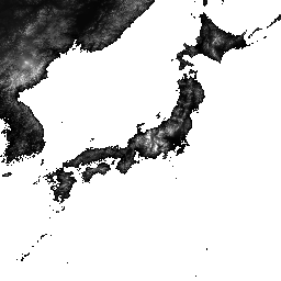
ALOS World 3D - 30m (AW3D30) 是一项全球数字地表模型 (DSM) 数据集,水平分辨率约为 30 米(1 角秒网格)。该数据集基于世界 3D 地形数据的 DSM 数据集(5 米网格版本)。更多详情… ALOS DEM 海拔 海拔-地形 地球物理 JAXA -
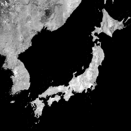
ALOS/AVNIR-2 ORI

此数据集包含来自“大地”号高级陆地观测卫星 (ALOS) 上搭载的高级可见光近红外辐射计 2 型 (AVNIR-2) 传感器的正射校正影像。AVNIR-2 ORI 产品是根据 AVNIR-2 1B1 数据在与 ALOS 的全色遥感 … alos jaxa orthophoto satellite-imagery visible -
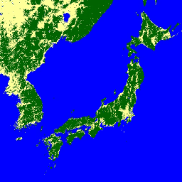
GHSL:全球建筑物高度 2018 年(P2023A)

此空间栅格数据集描绘了 2018 年全球建筑物高度分布情况,分辨率为 100 米。用于预测建筑物高度的输入数据包括 ALOS 全球数字地表模型 (30 m)、NASA 航天飞机雷达地形任务 … alos building built built-environment builtup copernicus -
GHSL:全球建筑体积 1975-2030 年 (P2023A)

此栅格数据集描绘了建筑物体积的全球分布情况,以每 100 米网格单元的立方米数表示。该数据集用于衡量总建筑体积以及分配给主要为非住宅 (NRES) 用途的网格单元的建筑体积。估算值基于累积的… alos building built-environment copernicus dem ghsl -
全球三类 PALSAR-2/PALSAR 森林/非森林地图
您可以在 JAXA/ALOS/PALSAR/YEARLY/FNF4 中找到此数据集的更新版本,其中包含 2017-2020 年的 4 个类别。全球森林/非森林地图 (FNF) 是通过对全球 25 米分辨率 PALSAR-2/PALSAR SAR 镶嵌中的 SAR 图像(后向散射系数)进行分类而生成的,因此强后向散射像素和低后向散射像素… ALOS alos2 分类 eroc 森林 森林生物质 -
全球 4 类 PALSAR-2/PALSAR 森林/非森林地图

全球森林/非森林 (FNF) 地图是通过对全球 25 米分辨率 PALSAR-2/PALSAR SAR 镶嵌图中的 SAR 图像(后向散射系数)进行分类而生成的,以便将强后向散射像素和低后向散射像素分别指定为“森林”和“非森林”。在此,“森林”是指具有以下特征的天然森林… ALOS alos2 分类 eroc 森林 森林生物质 -
全球 PALSAR-2/PALSAR 年度镶嵌图,版本 1
您可以在 JAXA/ALOS/PALSAR/YEARLY/SAR_EPOCH 中找到此数据集的新版本,其中包含 2015 年至 2021 年的数据。全球 25 米 PALSAR/PALSAR-2 镶嵌图是一张无缝的全球 SAR 图像,通过将 PALSAR/PALSAR-2 的条带状 SAR 图像镶嵌在一起而创建。对于每个年份和地点,我们选择了条带数据… alos alos2 eroc jaxa palsar palsar2 -
全球 PALSAR-2/PALSAR 年度镶嵌图,版本 2.5.0

全球 25 米 PALSAR/PALSAR-2 镶嵌图是一张无缝的全球 SAR 图像,通过将 PALSAR/PALSAR-2 的条带状 SAR 图像镶嵌在一起而创建。对于每个年份和位置,条带数据是通过对相应时间段内可用的浏览镶嵌图进行目视检查来选择的,其中显示最小… alos alos2 eroc jaxa palsar palsar2
Datasets tagged alos in Earth Engine
[null,null,[],[],[]]