-
ALOS-2 PALSAR-2 StripMap Level 2.1

自 2024 年 1 月 1 日晚间起,根据日本各部委和相关组织的要求,JAXA 实施了 ALOS-2 PALSAR-2 紧急观测。由于 JAXA 预计这些紧急观测数据对于灾害管理非常有用,因此 JAXA 决定在 … 上公开这些数据 alos2 eroc jaxa palsar2 radar sar -
Global 3-class PALSAR-2/PALSAR Forest/Non-Forest Map
您可以在 JAXA/ALOS/PALSAR/YEARLY/FNF4 中找到此数据集的较新版本,其中包含 2017-2020 年的 4 类数据。全球森林/非森林地图 (FNF) 是通过对全球 25 米分辨率 PALSAR-2/PALSAR SAR 镶嵌中的 SAR 图像(反向散射系数)进行分类而生成的,以便将强反向散射像素和低反向散射像素 … alos alos2 classification eroc forest forest-biomass -
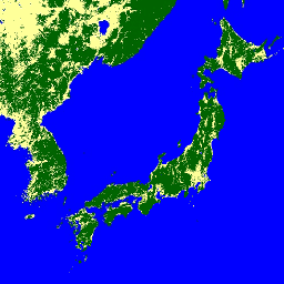
Global 4-class PALSAR-2/PALSAR Forest/Non-Forest Map

全球森林/非森林地图 (FNF) 是通过对全球 25 米分辨率 PALSAR-2/PALSAR SAR 镶嵌中的 SAR 图像(反向散射系数)进行分类而生成的,以便将强反向散射像素和低反向散射像素分别指定为“森林”和“非森林”。在这里,“森林”被定义为具有 … 的天然森林 alos alos2 classification eroc forest forest-biomass -
Global PALSAR-2/PALSAR Yearly Mosaic, version 1
您可以在 JAXA/ALOS/PALSAR/YEARLY/SAR_EPOCH 中找到此数据集的较新版本,其中包含 2015-2021 年的数据。全球 25 米 PALSAR/PALSAR-2 镶嵌是无缝的全球 SAR 图像,由 PALSAR/PALSAR-2 的 SAR 图像条带镶嵌而成。对于每个年份和位置,系统会选择条带数据 … alos alos2 eroc jaxa palsar palsar2 -
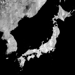
Global PALSAR-2/PALSAR Yearly Mosaic, version 2.5.0

全球 25 米 PALSAR/PALSAR-2 镶嵌是无缝的全球 SAR 图像,由 PALSAR/PALSAR-2 的 SAR 图像条带镶嵌而成。对于每个年份和位置,系统会通过直观检查该期间提供的浏览镶嵌来选择条带数据,并选择显示最小 … 的条带数据 alos alos2 eroc jaxa palsar palsar2 -
PALSAR-2 ScanSAR Level 2.2

25 米 PALSAR-2 ScanSAR 是 PALSAR-2 广域观测模式的归一化反向散射数据,观测宽度为 350 公里。SAR 图像使用 ALOS World 3D - 30 米 (AW3D30) 数字地表模型进行了正射校正和坡度校正。偏振数据存储在 … alos2 eroc jaxa palsar2 radar sar
Datasets tagged alos2 in Earth Engine
[null,null,[],[],[]]