-
USDA NASS 农地数据图层
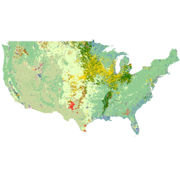
农地数据层 (CDL) 是一种专门针对农作物的土地覆盖数据层,每年都会使用中等分辨率的卫星图像和大量农业地面真实数据为美国大陆创建。CDL 由美国农业部、国家农业统计局 (NASS)、研究与开发司、… 农地 土地覆盖 美国农业部 -
GFSAD1000:农地范围 1 公里多项研究作物掩膜,全球粮食支持分析数据

GFSAD 是 NASA 资助的一个项目,旨在提供高分辨率的全球农地数据及其用水情况,为 21 世纪实现全球粮食安全做出贡献。GFSAD 产品是通过多传感器遥感数据(例如Landsat、MODIS、AVHRR)、次级数据和田地数据… crop cropland landcover usgs
Datasets tagged cropland in Earth Engine
[null,null,[],[],["The USDA NASS Cropland Data Layer (CDL) is an annual, crop-specific land cover dataset for the continental US, derived from satellite imagery and ground data. The USGS GFSAD1000 project provides high-resolution global cropland data, including water use, utilizing multi-sensor remote sensing data, secondary sources, and field-plot data, to enhance global food security analysis. Both focus on cropland and land cover.\n"]]