-
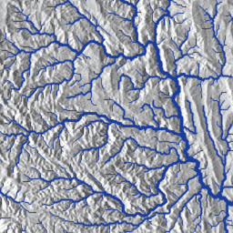
MERIT Hydro:全球水文数据集
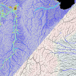
MERIT Hydro 是一张新的全球水流方向地图,分辨率为 3 角秒(赤道处约为 90 米),基于 MERIT DEM 海拔数据和水体数据集(G1WBM、GSWO 和 OpenStreetMap)的版本 1.0.3 派生而来。MERIT Hydro 包含新… dem elevation hydrography hydrosheds merit river-width -
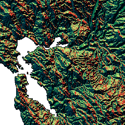
MERIT Hydro:补充可视化图层

MERIT Hydro 的补充可视化图层 水文 HydroSHEDS MERIT 河宽 地表水和地下水 上游排水区 -
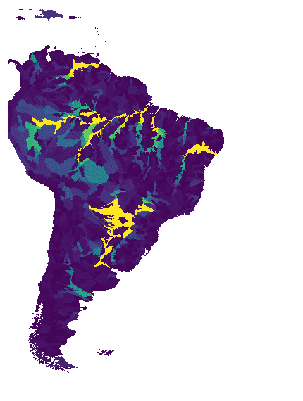
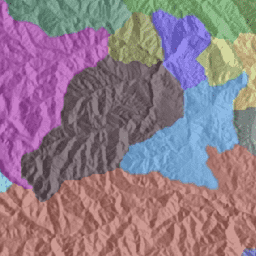
WWF HydroATLAS 流域级别 03

BasinATLAS 是 HydroATLAS 数据库的一个组成部分,而 HydroATLAS 数据库是 HydroSHEDS 的一个组成部分。BasinATLAS 以高空间分辨率为世界上的所有流域提供标准化的水文环境属性信息汇编。此数据集包含 56 个变量的数据,分为 281 个属性和… 地球物理 hydroatlas 水文 水文学 hydrosheds srtm -
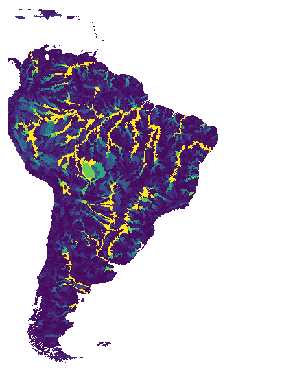
WWF HydroATLAS 流域级别 04

BasinATLAS 是 HydroATLAS 数据库的一个组成部分,而 HydroATLAS 数据库是 HydroSHEDS 的一个组成部分。BasinATLAS 以高空间分辨率为世界上的所有流域提供标准化的水文环境属性信息汇编。此数据集包含 56 个变量的数据,分为 281 个属性和… 地球物理 hydroatlas 水文 水文学 hydrosheds srtm -
WWF HydroATLAS 流域级别 05

BasinATLAS 是 HydroATLAS 数据库的一个组成部分,而 HydroATLAS 数据库是 HydroSHEDS 的一个组成部分。BasinATLAS 以高空间分辨率为世界上的所有流域提供标准化的水文环境属性信息汇编。此数据集包含 56 个变量的数据,分为 281 个属性和… 地球物理 hydroatlas 水文 水文学 hydrosheds srtm -
WWF HydroATLAS 流域级别 06
BasinATLAS 是 HydroATLAS 数据库的一个组成部分,而 HydroATLAS 数据库是 HydroSHEDS 的一个组成部分。BasinATLAS 以高空间分辨率为世界上的所有流域提供标准化的水文环境属性信息汇编。此数据集包含 56 个变量的数据,分为 281 个属性和… 地球物理 hydroatlas 水文 水文学 hydrosheds srtm -
WWF HydroATLAS 流域级别 07
BasinATLAS 是 HydroATLAS 数据库的一个组成部分,而 HydroATLAS 数据库是 HydroSHEDS 的一个组成部分。BasinATLAS 以高空间分辨率为世界上的所有流域提供标准化的水文环境属性信息汇编。此数据集包含 56 个变量的数据,分为 281 个属性和… 地球物理 hydroatlas 水文 水文学 hydrosheds srtm -
WWF HydroATLAS 流域级别 08

BasinATLAS 是 HydroATLAS 数据库的一个组成部分,而 HydroATLAS 数据库是 HydroSHEDS 的一个组成部分。BasinATLAS 以高空间分辨率为世界上的所有流域提供标准化的水文环境属性信息汇编。此数据集包含 56 个变量的数据,分为 281 个属性和… 地球物理 hydroatlas 水文 水文学 hydrosheds srtm -
WWF HydroATLAS 流域级别 09

BasinATLAS 是 HydroATLAS 数据库的一个组成部分,而 HydroATLAS 数据库是 HydroSHEDS 的一个组成部分。BasinATLAS 以高空间分辨率为世界上的所有流域提供标准化的水文环境属性信息汇编。此数据集包含 56 个变量的数据,分为 281 个属性和… 地球物理 hydroatlas 水文 水文学 hydrosheds srtm -
WWF HydroATLAS 流域级别 10
BasinATLAS 是 HydroATLAS 数据库的一个组成部分,而 HydroATLAS 数据库是 HydroSHEDS 的一个组成部分。BasinATLAS 以高空间分辨率为世界上的所有流域提供标准化的水文环境属性信息汇编。此数据集包含 56 个变量的数据,分为 281 个属性和… 地球物理 hydroatlas 水文 水文学 hydrosheds srtm -
WWF HydroATLAS 流域级别 11

BasinATLAS 是 HydroATLAS 数据库的一个组成部分,而 HydroATLAS 数据库是 HydroSHEDS 的一个组成部分。BasinATLAS 以高空间分辨率为世界上的所有流域提供标准化的水文环境属性信息汇编。此数据集包含 56 个变量的数据,分为 281 个属性和… 地球物理 hydroatlas 水文 水文学 hydrosheds srtm -
WWF HydroATLAS 流域级别 12

BasinATLAS 是 HydroATLAS 数据库的一个组成部分,而 HydroATLAS 数据库是 HydroSHEDS 的一个组成部分。BasinATLAS 以高空间分辨率为世界上的所有流域提供标准化的水文环境属性信息汇编。此数据集包含 56 个变量的数据,分为 281 个属性和… 地球物理 hydroatlas 水文 水文学 hydrosheds srtm -
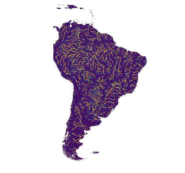
WWF HydroSHEDS 盆地级别 1

HydroSHEDS 是一种地图产品,可提供格式一致的水文地理信息,适用于区域和全球范围的应用。它提供了一套不同比例的地理参考数据集(矢量和栅格),包括河流网络、分水岭边界、排水方向和流量累积。HydroSHEDS 基于… 地球物理 水文地理 水文 HydroSHEDS SRTM 地表水-地下水 -
WWF HydroSHEDS 盆地级别 10
HydroSHEDS 是一种地图产品,可提供格式一致的水文地理信息,适用于区域和全球范围的应用。它提供了一套不同比例的地理参考数据集(矢量和栅格),包括河流网络、分水岭边界、排水方向和流量累积。HydroSHEDS 基于… 地球物理 水文地理 水文 HydroSHEDS SRTM 地表水-地下水 -
WWF HydroSHEDS 盆地级别 11

HydroSHEDS 是一种地图产品,可提供格式一致的水文地理信息,适用于区域和全球范围的应用。它提供了一套不同比例的地理参考数据集(矢量和栅格),包括河流网络、分水岭边界、排水方向和流量累积。HydroSHEDS 基于… 地球物理 水文地理 水文 HydroSHEDS SRTM 地表水-地下水 -
WWF HydroSHEDS 盆地级别 12

HydroSHEDS 是一种地图产品,可提供格式一致的水文地理信息,适用于区域和全球范围的应用。它提供了一套不同比例的地理参考数据集(矢量和栅格),包括河流网络、分水岭边界、排水方向和流量累积。HydroSHEDS 基于… 地球物理 水文地理 水文 HydroSHEDS SRTM 地表水-地下水 -
WWF HydroSHEDS 盆地级别 2

HydroSHEDS 是一种地图产品,可提供格式一致的水文地理信息,适用于区域和全球范围的应用。它提供了一套不同比例的地理参考数据集(矢量和栅格),包括河流网络、分水岭边界、排水方向和流量累积。HydroSHEDS 基于… 地球物理 水文地理 水文 HydroSHEDS SRTM 地表水-地下水 -
WWF HydroSHEDS 盆地级别 3

HydroSHEDS 是一种地图产品,可提供格式一致的水文地理信息,适用于区域和全球范围的应用。它提供了一套不同比例的地理参考数据集(矢量和栅格),包括河流网络、分水岭边界、排水方向和流量累积。HydroSHEDS 基于… 地球物理 水文地理 水文 HydroSHEDS SRTM 地表水-地下水 -
WWF HydroSHEDS 盆地级别 4

HydroSHEDS 是一种地图产品,可提供格式一致的水文地理信息,适用于区域和全球范围的应用。它提供了一套不同比例的地理参考数据集(矢量和栅格),包括河流网络、分水岭边界、排水方向和流量累积。HydroSHEDS 基于… 地球物理 水文地理 水文 HydroSHEDS SRTM 地表水-地下水 -
WWF HydroSHEDS 流域级别 5

HydroSHEDS 是一种地图产品,可提供格式一致的水文地理信息,适用于区域和全球范围的应用。它提供了一套不同比例的地理参考数据集(矢量和栅格),包括河流网络、分水岭边界、排水方向和流量累积。HydroSHEDS 基于… 地球物理 水文地理 水文 HydroSHEDS SRTM 地表水-地下水 -
WWF HydroSHEDS 盆地第 6 级

HydroSHEDS 是一种地图产品,可提供格式一致的水文地理信息,适用于区域和全球范围的应用。它提供了一套不同比例的地理参考数据集(矢量和栅格),包括河流网络、分水岭边界、排水方向和流量累积。HydroSHEDS 基于… 地球物理 水文地理 水文 HydroSHEDS SRTM 地表水-地下水 -
WWF HydroSHEDS 盆地第 7 级

HydroSHEDS 是一种地图产品,可提供格式一致的水文地理信息,适用于区域和全球范围的应用。它提供了一套不同比例的地理参考数据集(矢量和栅格),包括河流网络、分水岭边界、排水方向和流量累积。HydroSHEDS 基于… 地球物理 水文地理 水文 HydroSHEDS SRTM 地表水-地下水 -
WWF HydroSHEDS 盆地 8 级

HydroSHEDS 是一种地图产品,可提供格式一致的水文地理信息,适用于区域和全球范围的应用。它提供了一套不同比例的地理参考数据集(矢量和栅格),包括河流网络、分水岭边界、排水方向和流量累积。HydroSHEDS 基于… 地球物理 水文地理 水文 HydroSHEDS SRTM 地表水-地下水 -
WWF HydroSHEDS 流域第 9 级

HydroSHEDS 是一种地图产品,可提供格式一致的水文地理信息,适用于区域和全球范围的应用。它提供了一套不同比例的地理参考数据集(矢量和栅格),包括河流网络、分水岭边界、排水方向和流量累积。HydroSHEDS 基于… 地球物理 水文地理 水文 HydroSHEDS SRTM 地表水-地下水 -
WWF HydroSHEDS 排水方向,15 角秒
HydroSHEDS 是一种地图产品,可提供格式一致的水文地理信息,适用于区域和全球范围的应用。它提供了一套不同比例的地理参考数据集(矢量和栅格),包括河流网络、分水岭边界、排水方向和流量累积。HydroSHEDS 基于… 方向 排水 流向 地球物理 水文地理 水文 -
WWF HydroSHEDS 水流方向,3 角秒

HydroSHEDS 是一种地图产品,可提供格式一致的水文地理信息,适用于区域和全球范围的应用。它提供了一套不同比例的地理参考数据集(矢量和栅格),包括河流网络、分水岭边界、排水方向和流量累积。HydroSHEDS 基于… 方向 排水 流向 地球物理 水文地理 水文 -
WWF HydroSHEDS 水流方向,30 角秒

HydroSHEDS 是一种地图产品,可提供格式一致的水文地理信息,适用于区域和全球范围的应用。它提供了一套不同比例的地理参考数据集(矢量和栅格),包括河流网络、分水岭边界、排水方向和流量累积。HydroSHEDS 基于… 方向 排水 流向 地球物理 水文地理 水文 -
WWF HydroSHEDS 流向累积,15 角秒

HydroSHEDS 是一种地图产品,可提供格式一致的水文地理信息,适用于区域和全球范围的应用。它提供了一套不同比例的地理参考数据集(矢量和栅格),包括河流网络、分水岭边界、排水方向和流量累积。HydroSHEDS 基于… 累积 排水 流 地球物理 水文地理 水文 -
WWF HydroSHEDS 流向累积,30 角秒

HydroSHEDS 是一种地图产品,可提供格式一致的水文地理信息,适用于区域和全球范围的应用。它提供了一套不同比例的地理参考数据集(矢量和栅格),包括河流网络、分水岭边界、排水方向和流量累积。HydroSHEDS 基于… 累积 排水 流 地球物理 水文地理 水文 -
WWF HydroSHEDS Free Flowing Rivers Network v1
HydroSHEDS 是一种地图产品,可提供格式一致的水文地理信息,适用于区域和全球范围的应用。它提供了一套不同比例的地理参考数据集(矢量和栅格),包括河流网络、分水岭边界、排水方向和流量累积。HydroSHEDS 基于… 地球物理 水文地理 水文 HydroSHEDS SRTM 地表水-地下水 -
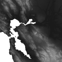
WWF HydroSHEDS 水文条件 DEM,15 角秒

HydroSHEDS 是一种地图产品,可提供格式一致的水文地理信息,适用于区域和全球范围的应用。它提供了一套不同比例的地理参考数据集(矢量和栅格),包括河流网络、分水岭边界、排水方向和流量累积。HydroSHEDS 基于… 有条件 dem 海拔 地球物理 水文 水文 -
WWF HydroSHEDS 水文条件 DEM,3 角秒
HydroSHEDS 是一种地图产品,可提供格式一致的水文地理信息,适用于区域和全球范围的应用。它提供了一套不同比例的地理参考数据集(矢量和栅格),包括河流网络、分水岭边界、排水方向和流量累积。HydroSHEDS 基于… 有条件 dem 海拔 地球物理 水文 水文 -
WWF HydroSHEDS 水文条件 DEM,30 角秒
HydroSHEDS 是一种地图产品,可提供格式一致的水文地理信息,适用于区域和全球范围的应用。它提供了一套不同比例的地理参考数据集(矢量和栅格),包括河流网络、分水岭边界、排水方向和流量累积。HydroSHEDS 基于… 有条件 dem 海拔 地球物理 水文 水文 -
WWF HydroSHEDS 空白填充 DEM,3 角秒
HydroSHEDS 是一种地图产品,可提供格式一致的水文地理信息,适用于区域和全球范围的应用。它提供了一套不同比例的地理参考数据集(矢量和栅格),包括河流网络、分水岭边界、排水方向和流量累积。HydroSHEDS 基于… dem 海拔 地球物理 水文地理 水文 hydrosheds
Datasets tagged hydrosheds in Earth Engine
[null,null,[],[],["MERIT Hydro offers a global flow direction map derived from MERIT DEM elevation data and water body datasets, with visualization layers. WWF HydroATLAS Basins, part of HydroSHEDS, provides detailed hydro-environmental attributes for watersheds at high spatial resolution. WWF HydroSHEDS delivers hydrographic data like river networks, watershed boundaries, drainage directions, flow accumulation, and different resolution DEMs in raster and vector formats, for regional and global analyses. Basins are available in various levels and the datasets are based on the HydroSHEDS model.\n"]]