-
NLCD 2019:美国地质调查局国家土地覆盖数据库,2019 年版本
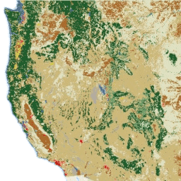
NLCD(国家土地覆盖数据库)是一个基于 Landsat 的 30 米土地覆盖数据库,涵盖 8 个时期(2001 年、2004 年、2006 年、2008 年、2011 年、2013 年、2016 年和 2019 年)。此处还提供了 2021 年的第九个时期。这些图片依赖于城市不透水面数据层… blm landcover landuse-landcover mrlc nlcd usgs -
NLCD 2021:美国地质调查局国家土地覆盖数据库,2021 年版本
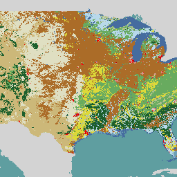
美国地质调查局 (USGS) 与多家联邦机构合作,现已开发并发布了七个国家土地覆盖数据库 (NLCD) 产品:NLCD 1992、2001、2006、2011、2016、2019 和 2021。从 2016 年版本开始,土地覆盖产品以两到三年为间隔创建… blm landcover landuse-landcover mrlc nlcd usgs
Datasets tagged mrlc in Earth Engine
[null,null,[],[],["The USGS National Land Cover Database (NLCD) provides 30-meter land cover data from Landsat imagery. It includes nine epochs: 2001, 2004, 2006, 2008, 2011, 2013, 2016, 2019, and 2021. NLCD products have been released for seven datasets : 1992, 2001, 2006, 2011, 2016, 2019 and 2021. The 2016 release started using two-to-three-year intervals. The data, which relies on imperviousness layers for urban areas, are created in partnership with federal agencies.\n"]]