-
GLIMS 2023: מדידות של קרח יבשתי גלובלי מהחלל

Global Land Ice Measurements from Space (או GLIMS) הוא פרויקט בינלאומי שמטרתו לבצע סקרים חוזרים של כ-200,000 הקרחונים בעולם. מטרת הפרויקט היא ליצור מלאי מקיף של קרח יבשתי ברחבי העולם, כולל מדידות של שטח קרחון, גיאומטריה, מהירות פני השטח וקו השלג… cryosphere glacier glims ice landcover nasa -
GLIMS Current: Global Land Ice Measurements From Space
Global Land Ice Measurements from Space (או GLIMS) הוא פרויקט בינלאומי שמטרתו לבצע סקרים חוזרים של כ-200,000 הקרחונים בעולם. מטרת הפרויקט היא ליצור מלאי מקיף של קרח יבשתי ברחבי העולם, כולל מדידות של שטח קרחון, גיאומטריה, מהירות פני השטח וקו השלג… cryosphere glacier glims ice landcover nasa -
MOD10A1.061 Terra Snow Cover Daily Global 500m

המוצר MOD10A1 V6.1 Snow Cover Daily Global 500m מכיל נתונים של כיסוי שלג, אלבדו של שלג, כיסוי שלג חלקי והערכת איכות (QA). נתוני כיסוי השלג מבוססים על אלגוריתם למיפוי שלג שמשתמש במדד שלג בהפרש מנורמל (NDSI) ובבדיקות קריטריונים אחרות. כללי … albedo cryosphere daily geophysical global modis -
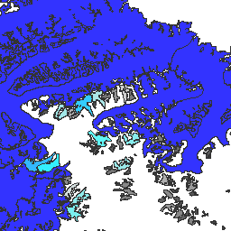
MOD10A2.061 Terra Snow Cover 8-Day L3 Global 500m

MOD10A2 הוא מערך נתונים של כיסוי שלג מ-MODIS בלוויין Terra. מערך הנתונים מציג את היקף כיסוי השלג המקסימלי במהלך תקופה של שמונה ימים ברזולוציה של 500 מ'. תקופת הקומפוזיציה שנבחרה היא שמונה ימים, כי זהו בדיוק מחזור החזרה של מסלול הקרקע… cryosphere daily geophysical global modis nasa -
MYD10A1.061 Aqua Snow Cover Daily Global 500m

המוצר MYD10A1 V6 Snow Cover Daily Global 500m מכיל נתונים של כיסוי שלג, אלבדו של שלג, כיסוי שלג חלקי והערכת איכות (QA). נתוני כיסוי השלג מבוססים על אלגוריתם למיפוי שלג שמשתמש במדד שלג בהפרש מנורמל (NDSI) ובבדיקות קריטריונים אחרות. כללי … albedo aqua cryosphere daily geophysical global
Datasets tagged nsidc in Earth Engine
[null,null,[],[],["GLIMS aims to inventory 200,000 glaciers globally, measuring area, geometry, surface velocity, and snow line. MOD10A1 provides daily global snow cover data, including albedo and fractional cover, at 500m resolution, using an NDSI-based algorithm. MOD10A2 tracks the maximum snow cover extent over eight-day periods at 500m resolution. MYD10A1 similarly offers daily global snow data, including albedo and fractional snow cover, at 500m, and is based on an NDSI algorithm.\n"]]