التعرّف على كيفية العثور على الموقع الجغرافي الحالي لجهاز Android وعرض تفاصيل المكان (نشاط تجاري أو نقطة اهتمام أخرى) في لذلك الموقع. اتبع هذا البرنامج التعليمي لإنشاء تطبيق Android باستخدام حزمة تطوير البرامج بالاستناد إلى بيانات "خرائط Google" لنظام التشغيل Android حزمة تطوير برامج الأماكن لنظام التشغيل Android و دمج موفِّر الموقع الجغرافي في واجهات برمجة التطبيقات للمواقع الجغرافية التي تخصّ "خدمات Google Play".
الحصول على الرمز
استنساخ أو نزّل ملف مستودع نماذج v2 لواجهة برمجة تطبيقات Android لخرائط Google من GitHub.
عرض إصدار Java للنشاط:
    // Copyright 2020 Google LLC
//
// Licensed under the Apache License, Version 2.0 (the "License");
// you may not use this file except in compliance with the License.
// You may obtain a copy of the License at
//
//      http://www.apache.org/licenses/LICENSE-2.0
//
// Unless required by applicable law or agreed to in writing, software
// distributed under the License is distributed on an "AS IS" BASIS,
// WITHOUT WARRANTIES OR CONDITIONS OF ANY KIND, either express or implied.
// See the License for the specific language governing permissions and
// limitations under the License.

package com.example.currentplacedetailsonmap;

import android.content.DialogInterface;
import android.content.pm.PackageManager;
import android.location.Location;
import android.os.Bundle;

import android.util.Log;
import android.view.Menu;
import android.view.MenuItem;
import android.view.View;
import android.widget.FrameLayout;
import android.widget.TextView;

import androidx.annotation.NonNull;
import androidx.appcompat.app.AlertDialog;
import androidx.appcompat.app.AppCompatActivity;
import androidx.core.app.ActivityCompat;
import androidx.core.content.ContextCompat;

import com.google.android.gms.location.FusedLocationProviderClient;
import com.google.android.gms.location.LocationServices;
import com.google.android.gms.maps.CameraUpdateFactory;
import com.google.android.gms.maps.GoogleMap;
import com.google.android.gms.maps.OnMapReadyCallback;
import com.google.android.gms.maps.SupportMapFragment;
import com.google.android.gms.maps.model.CameraPosition;
import com.google.android.gms.maps.model.LatLng;
import com.google.android.gms.maps.model.Marker;
import com.google.android.gms.maps.model.MarkerOptions;
import com.google.android.gms.tasks.OnCompleteListener;
import com.google.android.gms.tasks.Task;

import com.google.android.libraries.places.api.Places;
import com.google.android.libraries.places.api.model.Place;
import com.google.android.libraries.places.api.model.PlaceLikelihood;
import com.google.android.libraries.places.api.net.FindCurrentPlaceRequest;
import com.google.android.libraries.places.api.net.FindCurrentPlaceResponse;
import com.google.android.libraries.places.api.net.PlacesClient;

import java.util.Arrays;
import java.util.List;

/**
 * An activity that displays a map showing the place at the device's current location.
 */
public class MapsActivityCurrentPlace extends AppCompatActivity
        implements OnMapReadyCallback {

    private static final String TAG = MapsActivityCurrentPlace.class.getSimpleName();
    private GoogleMap map;
    private CameraPosition cameraPosition;

    // The entry point to the Places API.
    private PlacesClient placesClient;

    // The entry point to the Fused Location Provider.
    private FusedLocationProviderClient fusedLocationProviderClient;

    // A default location (Sydney, Australia) and default zoom to use when location permission is
    // not granted.
    private final LatLng defaultLocation = new LatLng(-33.8523341, 151.2106085);
    private static final int DEFAULT_ZOOM = 15;
    private static final int PERMISSIONS_REQUEST_ACCESS_FINE_LOCATION = 1;
    private boolean locationPermissionGranted;

    // The geographical location where the device is currently located. That is, the last-known
    // location retrieved by the Fused Location Provider.
    private Location lastKnownLocation;

    // Keys for storing activity state.
    private static final String KEY_CAMERA_POSITION = "camera_position";
    private static final String KEY_LOCATION = "location";

    // Used for selecting the current place.
    private static final int M_MAX_ENTRIES = 5;
    private String[] likelyPlaceNames;
    private String[] likelyPlaceAddresses;
    private List[] likelyPlaceAttributions;
    private LatLng[] likelyPlaceLatLngs;

    @Override
    protected void onCreate(Bundle savedInstanceState) {
        super.onCreate(savedInstanceState);

        // Retrieve location and camera position from saved instance state.
        if (savedInstanceState != null) {
            lastKnownLocation = savedInstanceState.getParcelable(KEY_LOCATION);
            cameraPosition = savedInstanceState.getParcelable(KEY_CAMERA_POSITION);
        }

        // Retrieve the content view that renders the map.
        setContentView(R.layout.activity_maps);

        // Construct a PlacesClient
        Places.initialize(getApplicationContext(), BuildConfig.PLACES_API_KEY);
        placesClient = Places.createClient(this);

        // Construct a FusedLocationProviderClient.
        fusedLocationProviderClient = LocationServices.getFusedLocationProviderClient(this);

        // Build the map.
        SupportMapFragment mapFragment = (SupportMapFragment) getSupportFragmentManager()
                .findFragmentById(R.id.map);
        mapFragment.getMapAsync(this);
    }

    /**
     * Saves the state of the map when the activity is paused.
     */
    @Override
    protected void onSaveInstanceState(Bundle outState) {
        if (map != null) {
            outState.putParcelable(KEY_CAMERA_POSITION, map.getCameraPosition());
            outState.putParcelable(KEY_LOCATION, lastKnownLocation);
        }
        super.onSaveInstanceState(outState);
    }

    /**
     * Sets up the options menu.
     * @param menu The options menu.
     * @return Boolean.
     */
    @Override
    public boolean onCreateOptionsMenu(Menu menu) {
        getMenuInflater().inflate(R.menu.current_place_menu, menu);
        return true;
    }

    /**
     * Handles a click on the menu option to get a place.
     * @param item The menu item to handle.
     * @return Boolean.
     */
    @Override
    public boolean onOptionsItemSelected(MenuItem item) {
        if (item.getItemId() == R.id.option_get_place) {
            showCurrentPlace();
        }
        return true;
    }

    /**
     * Manipulates the map when it's available.
     * This callback is triggered when the map is ready to be used.
     */
    @Override
    public void onMapReady(GoogleMap map) {
        this.map = map;

        // Use a custom info window adapter to handle multiple lines of text in the
        // info window contents.
        this.map.setInfoWindowAdapter(new GoogleMap.InfoWindowAdapter() {

            @Override
            // Return null here, so that getInfoContents() is called next.
            public View getInfoWindow(Marker arg0) {
                return null;
            }

            @Override
            public View getInfoContents(Marker marker) {
                // Inflate the layouts for the info window, title and snippet.
                View infoWindow = getLayoutInflater().inflate(R.layout.custom_info_contents,
                        (FrameLayout) findViewById(R.id.map), false);

                TextView title = infoWindow.findViewById(R.id.title);
                title.setText(marker.getTitle());

                TextView snippet = infoWindow.findViewById(R.id.snippet);
                snippet.setText(marker.getSnippet());

                return infoWindow;
            }
        });

        // Prompt the user for permission.
        getLocationPermission();

        // Turn on the My Location layer and the related control on the map.
        updateLocationUI();

        // Get the current location of the device and set the position of the map.
        getDeviceLocation();
    }

    /**
     * Gets the current location of the device, and positions the map's camera.
     */
    private void getDeviceLocation() {
        /*
         * Get the best and most recent location of the device, which may be null in rare
         * cases when a location is not available.
         */
        try {
            if (locationPermissionGranted) {
                Task<Location> locationResult = fusedLocationProviderClient.getLastLocation();
                locationResult.addOnCompleteListener(this, new OnCompleteListener<Location>() {
                    @Override
                    public void onComplete(@NonNull Task<Location> task) {
                        if (task.isSuccessful()) {
                            // Set the map's camera position to the current location of the device.
                            lastKnownLocation = task.getResult();
                            if (lastKnownLocation != null) {
                                map.moveCamera(CameraUpdateFactory.newLatLngZoom(
                                        new LatLng(lastKnownLocation.getLatitude(),
                                                lastKnownLocation.getLongitude()), DEFAULT_ZOOM));
                            }
                        } else {
                            Log.d(TAG, "Current location is null. Using defaults.");
                            Log.e(TAG, "Exception: %s", task.getException());
                            map.moveCamera(CameraUpdateFactory
                                    .newLatLngZoom(defaultLocation, DEFAULT_ZOOM));
                            map.getUiSettings().setMyLocationButtonEnabled(false);
                        }
                    }
                });
            }
        } catch (SecurityException e)  {
            Log.e("Exception: %s", e.getMessage(), e);
        }
    }

    /**
     * Prompts the user for permission to use the device location.
     */
    private void getLocationPermission() {
        /*
         * Request location permission, so that we can get the location of the
         * device. The result of the permission request is handled by a callback,
         * onRequestPermissionsResult.
         */
        if (ContextCompat.checkSelfPermission(this.getApplicationContext(),
                android.Manifest.permission.ACCESS_FINE_LOCATION)
                == PackageManager.PERMISSION_GRANTED) {
            locationPermissionGranted = true;
        } else {
            ActivityCompat.requestPermissions(this,
                    new String[]{android.Manifest.permission.ACCESS_FINE_LOCATION},
                    PERMISSIONS_REQUEST_ACCESS_FINE_LOCATION);
        }
    }

    /**
     * Handles the result of the request for location permissions.
     */
    @Override
    public void onRequestPermissionsResult(int requestCode,
                                           @NonNull String[] permissions,
                                           @NonNull int[] grantResults) {
        locationPermissionGranted = false;
        if (requestCode
            == PERMISSIONS_REQUEST_ACCESS_FINE_LOCATION) {// If request is cancelled, the result arrays are empty.
            if (grantResults.length > 0
                && grantResults[0] == PackageManager.PERMISSION_GRANTED) {
                locationPermissionGranted = true;
            }
        } else {
            super.onRequestPermissionsResult(requestCode, permissions, grantResults);
        }
        updateLocationUI();
    }

    /**
     * Prompts the user to select the current place from a list of likely places, and shows the
     * current place on the map - provided the user has granted location permission.
     */
    private void showCurrentPlace() {
        if (map == null) {
            return;
        }

        if (locationPermissionGranted) {
            // Use fields to define the data types to return.
            List<Place.Field> placeFields = Arrays.asList(Place.Field.NAME, Place.Field.ADDRESS,
                    Place.Field.LAT_LNG);

            // Use the builder to create a FindCurrentPlaceRequest.
            FindCurrentPlaceRequest request =
                    FindCurrentPlaceRequest.newInstance(placeFields);

            // Get the likely places - that is, the businesses and other points of interest that
            // are the best match for the device's current location.
            @SuppressWarnings("MissingPermission") final
            Task<FindCurrentPlaceResponse> placeResult =
                    placesClient.findCurrentPlace(request);
            placeResult.addOnCompleteListener (new OnCompleteListener<FindCurrentPlaceResponse>() {
                @Override
                public void onComplete(@NonNull Task<FindCurrentPlaceResponse> task) {
                    if (task.isSuccessful() && task.getResult() != null) {
                        FindCurrentPlaceResponse likelyPlaces = task.getResult();

                        // Set the count, handling cases where less than 5 entries are returned.
                        int count;
                        if (likelyPlaces.getPlaceLikelihoods().size() < M_MAX_ENTRIES) {
                            count = likelyPlaces.getPlaceLikelihoods().size();
                        } else {
                            count = M_MAX_ENTRIES;
                        }

                        int i = 0;
                        likelyPlaceNames = new String[count];
                        likelyPlaceAddresses = new String[count];
                        likelyPlaceAttributions = new List[count];
                        likelyPlaceLatLngs = new LatLng[count];

                        for (PlaceLikelihood placeLikelihood : likelyPlaces.getPlaceLikelihoods()) {
                            // Build a list of likely places to show the user.
                            likelyPlaceNames[i] = placeLikelihood.getPlace().getName();
                            likelyPlaceAddresses[i] = placeLikelihood.getPlace().getAddress();
                            likelyPlaceAttributions[i] = placeLikelihood.getPlace()
                                    .getAttributions();
                            likelyPlaceLatLngs[i] = placeLikelihood.getPlace().getLatLng();

                            i++;
                            if (i > (count - 1)) {
                                break;
                            }
                        }

                        // Show a dialog offering the user the list of likely places, and add a
                        // marker at the selected place.
                        MapsActivityCurrentPlace.this.openPlacesDialog();
                    }
                    else {
                        Log.e(TAG, "Exception: %s", task.getException());
                    }
                }
            });
        } else {
            // The user has not granted permission.
            Log.i(TAG, "The user did not grant location permission.");

            // Add a default marker, because the user hasn't selected a place.
            map.addMarker(new MarkerOptions()
                    .title(getString(R.string.default_info_title))
                    .position(defaultLocation)
                    .snippet(getString(R.string.default_info_snippet)));

            // Prompt the user for permission.
            getLocationPermission();
        }
    }

    /**
     * Displays a form allowing the user to select a place from a list of likely places.
     */
    private void openPlacesDialog() {
        // Ask the user to choose the place where they are now.
        DialogInterface.OnClickListener listener = new DialogInterface.OnClickListener() {
            @Override
            public void onClick(DialogInterface dialog, int which) {
                // The "which" argument contains the position of the selected item.
                LatLng markerLatLng = likelyPlaceLatLngs[which];
                String markerSnippet = likelyPlaceAddresses[which];
                if (likelyPlaceAttributions[which] != null) {
                    markerSnippet = markerSnippet + "\n" + likelyPlaceAttributions[which];
                }

                // Add a marker for the selected place, with an info window
                // showing information about that place.
                map.addMarker(new MarkerOptions()
                        .title(likelyPlaceNames[which])
                        .position(markerLatLng)
                        .snippet(markerSnippet));

                // Position the map's camera at the location of the marker.
                map.moveCamera(CameraUpdateFactory.newLatLngZoom(markerLatLng,
                        DEFAULT_ZOOM));
            }
        };

        // Display the dialog.
        AlertDialog dialog = new AlertDialog.Builder(this)
                .setTitle(R.string.pick_place)
                .setItems(likelyPlaceNames, listener)
                .show();
    }

    /**
     * Updates the map's UI settings based on whether the user has granted location permission.
     */
    private void updateLocationUI() {
        if (map == null) {
            return;
        }
        try {
            if (locationPermissionGranted) {
                map.setMyLocationEnabled(true);
                map.getUiSettings().setMyLocationButtonEnabled(true);
            } else {
                map.setMyLocationEnabled(false);
                map.getUiSettings().setMyLocationButtonEnabled(false);
                lastKnownLocation = null;
                getLocationPermission();
            }
        } catch (SecurityException e)  {
            Log.e("Exception: %s", e.getMessage());
        }
    }
}
عرض إصدار Kotlin للنشاط:
    // Copyright 2020 Google LLC
//
// Licensed under the Apache License, Version 2.0 (the "License");
// you may not use this file except in compliance with the License.
// You may obtain a copy of the License at
//
//      http://www.apache.org/licenses/LICENSE-2.0
//
// Unless required by applicable law or agreed to in writing, software
// distributed under the License is distributed on an "AS IS" BASIS,
// WITHOUT WARRANTIES OR CONDITIONS OF ANY KIND, either express or implied.
// See the License for the specific language governing permissions and
// limitations under the License.
package com.example.currentplacedetailsonmap

import android.Manifest
import android.annotation.SuppressLint
import android.content.DialogInterface
import android.content.pm.PackageManager
import android.location.Location
import android.os.Bundle
import android.util.Log
import android.view.Menu
import android.view.MenuItem
import android.view.View
import android.widget.FrameLayout
import android.widget.TextView
import androidx.appcompat.app.AlertDialog
import androidx.appcompat.app.AppCompatActivity
import androidx.core.app.ActivityCompat
import androidx.core.content.ContextCompat
import com.google.android.gms.location.FusedLocationProviderClient
import com.google.android.gms.location.LocationServices
import com.google.android.gms.maps.CameraUpdateFactory
import com.google.android.gms.maps.GoogleMap
import com.google.android.gms.maps.GoogleMap.InfoWindowAdapter
import com.google.android.gms.maps.OnMapReadyCallback
import com.google.android.gms.maps.SupportMapFragment
import com.google.android.gms.maps.model.CameraPosition
import com.google.android.gms.maps.model.LatLng
import com.google.android.gms.maps.model.Marker
import com.google.android.gms.maps.model.MarkerOptions
import com.google.android.libraries.places.api.Places
import com.google.android.libraries.places.api.model.Place
import com.google.android.libraries.places.api.net.FindCurrentPlaceRequest
import com.google.android.libraries.places.api.net.PlacesClient

/**
 * An activity that displays a map showing the place at the device's current location.
 */
class MapsActivityCurrentPlace : AppCompatActivity(), OnMapReadyCallback {
    private var map: GoogleMap? = null
    private var cameraPosition: CameraPosition? = null

    // The entry point to the Places API.
    private lateinit var placesClient: PlacesClient

    // The entry point to the Fused Location Provider.
    private lateinit var fusedLocationProviderClient: FusedLocationProviderClient

    // A default location (Sydney, Australia) and default zoom to use when location permission is
    // not granted.
    private val defaultLocation = LatLng(-33.8523341, 151.2106085)
    private var locationPermissionGranted = false

    // The geographical location where the device is currently located. That is, the last-known
    // location retrieved by the Fused Location Provider.
    private var lastKnownLocation: Location? = null
    private var likelyPlaceNames: Array<String?> = arrayOfNulls(0)
    private var likelyPlaceAddresses: Array<String?> = arrayOfNulls(0)
    private var likelyPlaceAttributions: Array<List<*>?> = arrayOfNulls(0)
    private var likelyPlaceLatLngs: Array<LatLng?> = arrayOfNulls(0)

    override fun onCreate(savedInstanceState: Bundle?) {
        super.onCreate(savedInstanceState)

        // Retrieve location and camera position from saved instance state.
        if (savedInstanceState != null) {
            lastKnownLocation = savedInstanceState.getParcelable(KEY_LOCATION)
            cameraPosition = savedInstanceState.getParcelable(KEY_CAMERA_POSITION)
        }

        // Retrieve the content view that renders the map.
        setContentView(R.layout.activity_maps)

        // Construct a PlacesClient
        Places.initialize(applicationContext, BuildConfig.MAPS_API_KEY)
        placesClient = Places.createClient(this)

        // Construct a FusedLocationProviderClient.
        fusedLocationProviderClient = LocationServices.getFusedLocationProviderClient(this)

        // Build the map.
        val mapFragment = supportFragmentManager
            .findFragmentById(R.id.map) as SupportMapFragment?
        mapFragment?.getMapAsync(this)
    }

    /**
     * Saves the state of the map when the activity is paused.
     */
    override fun onSaveInstanceState(outState: Bundle) {
        map?.let { map ->
            outState.putParcelable(KEY_CAMERA_POSITION, map.cameraPosition)
            outState.putParcelable(KEY_LOCATION, lastKnownLocation)
        }
        super.onSaveInstanceState(outState)
    }

    /**
     * Sets up the options menu.
     * @param menu The options menu.
     * @return Boolean.
     */
    override fun onCreateOptionsMenu(menu: Menu): Boolean {
        menuInflater.inflate(R.menu.current_place_menu, menu)
        return true
    }

    /**
     * Handles a click on the menu option to get a place.
     * @param item The menu item to handle.
     * @return Boolean.
     */
    override fun onOptionsItemSelected(item: MenuItem): Boolean {
        if (item.itemId == R.id.option_get_place) {
            showCurrentPlace()
        }
        return true
    }

    /**
     * Manipulates the map when it's available.
     * This callback is triggered when the map is ready to be used.
     */
    override fun onMapReady(map: GoogleMap) {
        this.map = map

        // Use a custom info window adapter to handle multiple lines of text in the
        // info window contents.
        this.map?.setInfoWindowAdapter(object : InfoWindowAdapter {
            // Return null here, so that getInfoContents() is called next.
            override fun getInfoWindow(arg0: Marker): View? {
                return null
            }

            override fun getInfoContents(marker: Marker): View {
                // Inflate the layouts for the info window, title and snippet.
                val infoWindow = layoutInflater.inflate(R.layout.custom_info_contents,
                    findViewById<FrameLayout>(R.id.map), false)
                val title = infoWindow.findViewById<TextView>(R.id.title)
                title.text = marker.title
                val snippet = infoWindow.findViewById<TextView>(R.id.snippet)
                snippet.text = marker.snippet
                return infoWindow
            }
        })

        // Prompt the user for permission.
        getLocationPermission()

        // Turn on the My Location layer and the related control on the map.
        updateLocationUI()

        // Get the current location of the device and set the position of the map.
        getDeviceLocation()
    }

    /**
     * Gets the current location of the device, and positions the map's camera.
     */
    @SuppressLint("MissingPermission")
    private fun getDeviceLocation() {
        /*
         * Get the best and most recent location of the device, which may be null in rare
         * cases when a location is not available.
         */
        try {
            if (locationPermissionGranted) {
                val locationResult = fusedLocationProviderClient.lastLocation
                locationResult.addOnCompleteListener(this) { task ->
                    if (task.isSuccessful) {
                        // Set the map's camera position to the current location of the device.
                        lastKnownLocation = task.result
                        if (lastKnownLocation != null) {
                            map?.moveCamera(CameraUpdateFactory.newLatLngZoom(
                                LatLng(lastKnownLocation!!.latitude,
                                    lastKnownLocation!!.longitude), DEFAULT_ZOOM.toFloat()))
                        }
                    } else {
                        Log.d(TAG, "Current location is null. Using defaults.")
                        Log.e(TAG, "Exception: %s", task.exception)
                        map?.moveCamera(CameraUpdateFactory
                            .newLatLngZoom(defaultLocation, DEFAULT_ZOOM.toFloat()))
                        map?.uiSettings?.isMyLocationButtonEnabled = false
                    }
                }
            }
        } catch (e: SecurityException) {
            Log.e("Exception: %s", e.message, e)
        }
    }

    /**
     * Prompts the user for permission to use the device location.
     */
    private fun getLocationPermission() {
        /*
         * Request location permission, so that we can get the location of the
         * device. The result of the permission request is handled by a callback,
         * onRequestPermissionsResult.
         */
        if (ContextCompat.checkSelfPermission(this.applicationContext,
                Manifest.permission.ACCESS_FINE_LOCATION)
            == PackageManager.PERMISSION_GRANTED) {
            locationPermissionGranted = true
        } else {
            ActivityCompat.requestPermissions(this, arrayOf(Manifest.permission.ACCESS_FINE_LOCATION),
                PERMISSIONS_REQUEST_ACCESS_FINE_LOCATION)
        }
    }

    /**
     * Handles the result of the request for location permissions.
     */
    override fun onRequestPermissionsResult(requestCode: Int,
                                            permissions: Array<String>,
                                            grantResults: IntArray) {
        locationPermissionGranted = false
        when (requestCode) {
            PERMISSIONS_REQUEST_ACCESS_FINE_LOCATION -> {

                // If request is cancelled, the result arrays are empty.
                if (grantResults.isNotEmpty() &&
                    grantResults[0] == PackageManager.PERMISSION_GRANTED) {
                    locationPermissionGranted = true
                }
            }
            else -> super.onRequestPermissionsResult(requestCode, permissions, grantResults)
        }
        updateLocationUI()
    }

    /**
     * Prompts the user to select the current place from a list of likely places, and shows the
     * current place on the map - provided the user has granted location permission.
     */
    @SuppressLint("MissingPermission")
    private fun showCurrentPlace() {
        if (map == null) {
            return
        }
        if (locationPermissionGranted) {
            // Use fields to define the data types to return.
            val placeFields = listOf(Place.Field.NAME, Place.Field.ADDRESS, Place.Field.LAT_LNG)

            // Use the builder to create a FindCurrentPlaceRequest.
            val request = FindCurrentPlaceRequest.newInstance(placeFields)

            // Get the likely places - that is, the businesses and other points of interest that
            // are the best match for the device's current location.
            val placeResult = placesClient.findCurrentPlace(request)
            placeResult.addOnCompleteListener { task ->
                if (task.isSuccessful && task.result != null) {
                    val likelyPlaces = task.result

                    // Set the count, handling cases where less than 5 entries are returned.
                    val count = if (likelyPlaces != null && likelyPlaces.placeLikelihoods.size < M_MAX_ENTRIES) {
                        likelyPlaces.placeLikelihoods.size
                    } else {
                        M_MAX_ENTRIES
                    }
                    var i = 0
                    likelyPlaceNames = arrayOfNulls(count)
                    likelyPlaceAddresses = arrayOfNulls(count)
                    likelyPlaceAttributions = arrayOfNulls<List<*>?>(count)
                    likelyPlaceLatLngs = arrayOfNulls(count)
                    for (placeLikelihood in likelyPlaces?.placeLikelihoods ?: emptyList()) {
                        // Build a list of likely places to show the user.
                        likelyPlaceNames[i] = placeLikelihood.place.name
                        likelyPlaceAddresses[i] = placeLikelihood.place.address
                        likelyPlaceAttributions[i] = placeLikelihood.place.attributions
                        likelyPlaceLatLngs[i] = placeLikelihood.place.latLng
                        i++
                        if (i > count - 1) {
                            break
                        }
                    }

                    // Show a dialog offering the user the list of likely places, and add a
                    // marker at the selected place.
                    openPlacesDialog()
                } else {
                    Log.e(TAG, "Exception: %s", task.exception)
                }
            }
        } else {
            // The user has not granted permission.
            Log.i(TAG, "The user did not grant location permission.")

            // Add a default marker, because the user hasn't selected a place.
            map?.addMarker(MarkerOptions()
                .title(getString(R.string.default_info_title))
                .position(defaultLocation)
                .snippet(getString(R.string.default_info_snippet)))

            // Prompt the user for permission.
            getLocationPermission()
        }
    }

    /**
     * Displays a form allowing the user to select a place from a list of likely places.
     */
    private fun openPlacesDialog() {
        // Ask the user to choose the place where they are now.
        val listener = DialogInterface.OnClickListener { dialog, which -> // The "which" argument contains the position of the selected item.
            val markerLatLng = likelyPlaceLatLngs[which]
            var markerSnippet = likelyPlaceAddresses[which]
            if (likelyPlaceAttributions[which] != null) {
                markerSnippet = """
                    $markerSnippet
                    ${likelyPlaceAttributions[which]}
                    """.trimIndent()
            }

            if (markerLatLng == null) {
                return@OnClickListener
            }

            // Add a marker for the selected place, with an info window
            // showing information about that place.
            map?.addMarker(MarkerOptions()
                .title(likelyPlaceNames[which])
                .position(markerLatLng)
                .snippet(markerSnippet))

            // Position the map's camera at the location of the marker.
            map?.moveCamera(CameraUpdateFactory.newLatLngZoom(markerLatLng,
                DEFAULT_ZOOM.toFloat()))
        }

        // Display the dialog.
        AlertDialog.Builder(this)
            .setTitle(R.string.pick_place)
            .setItems(likelyPlaceNames, listener)
            .show()
    }

    /**
     * Updates the map's UI settings based on whether the user has granted location permission.
     */
    @SuppressLint("MissingPermission")
    private fun updateLocationUI() {
        if (map == null) {
            return
        }
        try {
            if (locationPermissionGranted) {
                map?.isMyLocationEnabled = true
                map?.uiSettings?.isMyLocationButtonEnabled = true
            } else {
                map?.isMyLocationEnabled = false
                map?.uiSettings?.isMyLocationButtonEnabled = false
                lastKnownLocation = null
                getLocationPermission()
            }
        } catch (e: SecurityException) {
            Log.e("Exception: %s", e.message, e)
        }
    }

    companion object {
        private val TAG = MapsActivityCurrentPlace::class.java.simpleName
        private const val DEFAULT_ZOOM = 15
        private const val PERMISSIONS_REQUEST_ACCESS_FINE_LOCATION = 1

        // Keys for storing activity state.
        private const val KEY_CAMERA_POSITION = "camera_position"
        private const val KEY_LOCATION = "location"

        // Used for selecting the current place.
        private const val M_MAX_ENTRIES = 5
    }
}
إعداد مشروع التطوير
اتّبِع الخطوات التالية لإنشاء مشروع تعليمي في "استوديو Android".
- يمكنك التنزيل تثبيت "استوديو Android".
- إضافة حزمة خدمات Google Play لنظام التشغيل Android استوديو YouTube.
- نسخة طبق الأصل أو تنزيل مستودع نماذج v2 لواجهة برمجة تطبيقات Android في خرائط Google إذا كان لديك لم يفعل ذلك عندما بدأت قراءة هذا البرنامج التعليمي.
استيراد مشروع الدليل التعليمي:
- في "استوديو Android"، اختَر ملف > جديد > استيراد المشروع:
- انتقِل إلى الموقع الذي حفظت فيه مستودع نماذج v2 لواجهة برمجة تطبيقات Android لخرائط Google بعد تنزيله.
- ابحث عن مشروع CurrentPlaceDetailsOnMap على هذا
الموقع:
PATH-TO-SAVED-REPO/android-samples/tutorials/java/CurrentPlaceDetailsOnMap(Java) أو
PATH-TO-SAVED-REPO/android-samples/tutorials/kotlin/CurrentPlaceDetailsOnMap(Kotlin) - اختَر دليل المشروع، ثم انقر على فتح. جهاز Android بإمكان "استوديو YouTube" الآن إنشاء مشروعك باستخدام أداة إنشاء Gradle.
تفعيل واجهات برمجة التطبيقات اللازمة والحصول على مفتاح واجهة برمجة تطبيقات
لإكمال هذا الدليل التعليمي، تحتاج إلى مشروع على Google Cloud يتضمّن تفعيل واجهات برمجة التطبيقات ومفتاح واجهة برمجة التطبيقات المصرَّح له باستخدام حزمة تطوير البرامج بالاستناد إلى بيانات "خرائط Google" لنظام التشغيل Android لمزيد من التفاصيل، يُرجى الاطّلاع على:
لعرض واجهات برمجة التطبيقات التي تم تفعيلها، انتقِل إلى صفحة "منصة خرائط Google". في Cloud Console واختَر مشروعك:
الانتقال إلى صفحة "منصة خرائط Google"إذا لم تلاحظ أنه تم تفعيل واجهة برمجة تطبيقات الأماكن في مشروعك، يجب تفعيلها:
تفعيل Places APIإذا أضفت أي قيود إلى مفتاح واجهة برمجة التطبيقات، احرص على إضافة Places API. إلى المفتاح. راجِع استخدام مفاتيح واجهة برمجة التطبيقات لمزيد من المعلومات.
إضافة مفتاح واجهة برمجة التطبيقات إلى تطبيقك
- افتح ملف
local.propertiesالخاص بمشروعك. أضِف السلسلة التالية ثم استبدِل
YOUR_API_KEYبقيمة مفتاح واجهة برمجة التطبيقات:MAPS_API_KEY=YOUR_API_KEY
عند إنشاء تطبيقك، فإن المكوّن الإضافي السري لنظام Gradle المتوافق مع Android سينسخ مفتاح واجهة برمجة التطبيقات ويجعله متاحًا كمتغيّر إصدار في ملف بيان Android.
إنشاء تطبيقك وتشغيله
وصِّل جهاز Android بجهاز الكمبيوتر. اتّبِع الخطوات التالية: التعليمات لتفعيل خيارات المطوّرين على جهاز Android وتهيئة نظامك الكشف عن الجهاز.
وبدلاً من ذلك، يمكنك استخدام أجهزة Android مدير الأجهزة الافتراضية (AVD) لضبط جهاز افتراضي. عند اختيار محاكي، احرص على اختيار صورة تتضمن Google APIs. لمزيد من التفاصيل، يُرجى مراجعة إعداد مشروع على "استوديو Android"
- في "استوديو Android"، انقر على خيار القائمة تشغيل (أو انقر على زر ). اختَر جهازًا كما هو مطلوب.
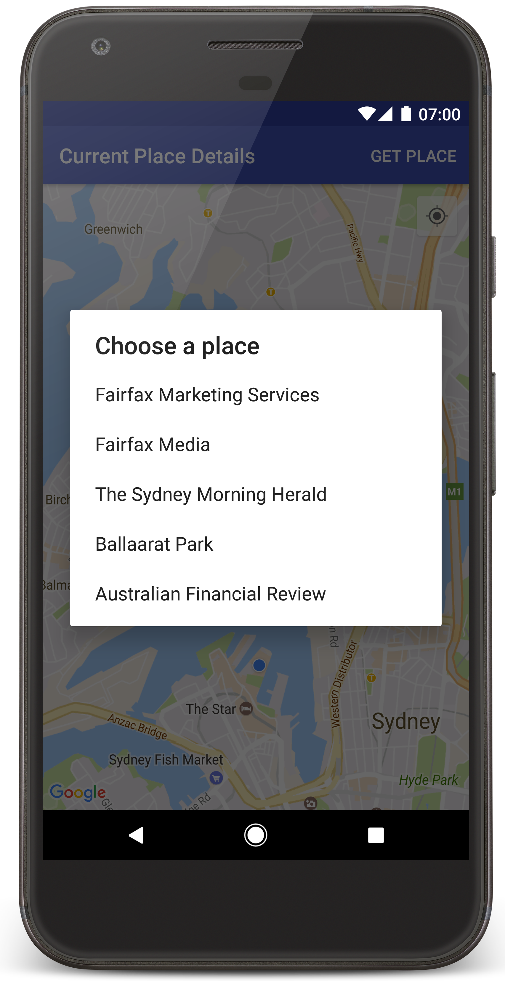
يستدعي Android Studio تطبيق Gradle لإنشاء التطبيق، ثم يشغِّله على الجهاز أو على المحاكي. من المفترض أن تظهر لك خريطة تحتوي على عدد من العلامات. حول موقعك الجغرافي الحالي، بشكل مشابه للصورة الواردة في هذه الصفحة
- اختَر الحصول على مكان لفتح قائمة بالأماكن (نشاط تجاري أو نقطة اهتمام أخرى). بالقرب من موقعك الحالي.
- اختَر مكانًا معينًا من القائمة. تمت إضافة علامة إلى الخريطة للمكان المحدد.
تحرّي الخلل وإصلاحه:
- إذا لم تظهر لك خريطة، تأكّد من أنّك حصلت على مفتاح واجهة برمجة تطبيقات وأضفته. إلى التطبيق، كما هو موضح أعلاه. التحقق من تسجيل الدخول Android Studio أجهزة Android عليك تتبُّع رسائل الخطأ بشأن مفتاح واجهة برمجة التطبيقات.
- إذا كانت الخريطة تعرض علامة واحدة فقط موجودة على جسر ميناء سيدني (الموقع الافتراضي المحدد في التطبيق)، فتأكد من منح إذن تحديد الموقع الجغرافي للتطبيق. يطلب التطبيق إذن تحديد الموقع الجغرافي في وقت التشغيل، وفقًا للنمط الموضَّح في Android دليل الأذونات يُرجى العِلم أنّه يمكنك أيضًا ضبط الأذونات مباشرةً على الجهاز، عن طريق اختيار الإعدادات > التطبيقات > اسم التطبيق > الأذونات > الموقع الجغرافي: لمزيد من التفاصيل حول كيفية التعامل مع الأذونات في الرمز، فراجع الدليل أدناه لطلب إذن تحديد الموقع الجغرافي في تطبيقك
- يمكنك استخدام أجهزة Android أدوات تصحيح الأخطاء في استوديو YouTube لعرض السجلات وتصحيح أخطاء التطبيق.
فهم الرمز البرمجي
يشرح هذا الجزء من البرنامج التعليمي أهم أجزاء CurrentPlaceDetailsOnMap، لمساعدتك على فهم كيفية إنشاء تطبيق مشابه.
إنشاء مثيل لبرنامج Places API
تعتبر هذه الكائنات نقاط الدخول الرئيسية إلى حزمة تطوير برامج الأماكن لأجهزة Android:
- تشير رسالة الأشكال البيانية
Placesهذه الفئة ينشئ ويدير عملاء لحزمة تطوير برامج الأماكن لأجهزة Android. - تشير رسالة الأشكال البيانية
PlacesClientالموقع الحالي للجهاز والأماكن القريبة من الموقع الجغرافي.
تعرض LocationServices هو نقطة الدخول الرئيسية لخدمات الموقع الجغرافي في Android
لاستخدام واجهات برمجة التطبيقات، عليك اتّباع الخطوات التالية في
onCreate()
للجزء أو النشاط:
- إعداد عنصر
Places - أنشئ عنصر
PlacesClient. - أنشئ عنصر
FusedLocationProviderClient.
على سبيل المثال:
Java
@Override
protected void onCreate(Bundle savedInstanceState) {
    super.onCreate(savedInstanceState);

    // ...

    // Retrieve the content view that renders the map.
    setContentView(R.layout.activity_maps);

    // Construct a PlacesClient
    Places.initialize(getApplicationContext(), getString(R.string.maps_api_key));
    placesClient = Places.createClient(this);

    // Construct a FusedLocationProviderClient.
    fusedLocationProviderClient = LocationServices.getFusedLocationProviderClient(this);
}
Kotlin
override fun onCreate(savedInstanceState: Bundle?) {
    super.onCreate(savedInstanceState)

    // ...

    // Retrieve the content view that renders the map.
    setContentView(R.layout.activity_maps)

    // Construct a PlacesClient
    Places.initialize(applicationContext, getString(R.string.maps_api_key))
    placesClient = Places.createClient(this)

    // Construct a FusedLocationProviderClient.
    fusedLocationProviderClient = LocationServices.getFusedLocationProviderClient(this)

}
طلب إذن تحديد الموقع الجغرافي
يجب أن يطلب تطبيقك إذن تحديد الموقع الجغرافي من أجل تحديد موقع الجهاز والسماح للمستخدم بالنقر على موقعي على الخريطة.
يوفّر هذا الدليل التوجيهي الرمز الذي تحتاجه لطلب إذن تحديد الموقع الجغرافي الدقيق. لمزيد من التفاصيل، اطّلع على دليل أجهزة Android الأذونات.
إضافة الإذن كعنصر فرعي لتطبيق
<manifest>في بيان Android:<manifest xmlns:android="http://schemas.android.com/apk/res/android" package="com.example.currentplacedetailsonmap"> <uses-permission android:name="android.permission.ACCESS_FINE_LOCATION" /> </manifest>يمكنك طلب أذونات التشغيل في تطبيقك لمنح المستخدم فرصة للسماح بإذن تحديد الموقع أو رفضه. يتم التحقق من الرمز البرمجي التالي: ما إذا كان المستخدم قد منح إذن تحديد الموقع الجغرافي الدقيق أم لا. إذا لم يكن كذلك، فإنه يطلب الإذن:
Java
private void getLocationPermission() { /* * Request location permission, so that we can get the location of the * device. The result of the permission request is handled by a callback, * onRequestPermissionsResult. */ if (ContextCompat.checkSelfPermission(this.getApplicationContext(), android.Manifest.permission.ACCESS_FINE_LOCATION) == PackageManager.PERMISSION_GRANTED) { locationPermissionGranted = true; } else { ActivityCompat.requestPermissions(this, new String[]{android.Manifest.permission.ACCESS_FINE_LOCATION}, PERMISSIONS_REQUEST_ACCESS_FINE_LOCATION); } }Kotlin
private fun getLocationPermission() { /* * Request location permission, so that we can get the location of the * device. The result of the permission request is handled by a callback, * onRequestPermissionsResult. */ if (ContextCompat.checkSelfPermission(this.applicationContext, Manifest.permission.ACCESS_FINE_LOCATION) == PackageManager.PERMISSION_GRANTED) { locationPermissionGranted = true } else { ActivityCompat.requestPermissions(this, arrayOf(Manifest.permission.ACCESS_FINE_LOCATION), PERMISSIONS_REQUEST_ACCESS_FINE_LOCATION) } }إلغاء معاودة الاتصال "
onRequestPermissionsResult()" من أجل التعامل مع نتيجة طلب الإذن:Java
@Override public void onRequestPermissionsResult(int requestCode, @NonNull String[] permissions, @NonNull int[] grantResults) { locationPermissionGranted = false; if (requestCode == PERMISSIONS_REQUEST_ACCESS_FINE_LOCATION) {// If request is cancelled, the result arrays are empty. if (grantResults.length > 0 && grantResults[0] == PackageManager.PERMISSION_GRANTED) { locationPermissionGranted = true; } } else { super.onRequestPermissionsResult(requestCode, permissions, grantResults); } updateLocationUI(); }Kotlin
override fun onRequestPermissionsResult(requestCode: Int, permissions: Array<String>, grantResults: IntArray) { locationPermissionGranted = false when (requestCode) { PERMISSIONS_REQUEST_ACCESS_FINE_LOCATION -> { // If request is cancelled, the result arrays are empty. if (grantResults.isNotEmpty() && grantResults[0] == PackageManager.PERMISSION_GRANTED) { locationPermissionGranted = true } } else -> super.onRequestPermissionsResult(requestCode, permissions, grantResults) } updateLocationUI() }يصف قسم لاحق من هذا البرنامج التعليمي طريقة
updateLocationUI().
إضافة خريطة
يمكنك عرض خريطة باستخدام حزمة تطوير البرامج بالاستناد إلى بيانات "خرائط Google" لتطبيقات Android.
أضِف عنصر
<fragment>إلى تنسيق نشاطك.activity_maps.xml. يحدد هذا العنصرSupportMapFragmentليكون بمثابة حاوية للخريطة وإتاحة الوصول إلى الكائنGoogleMap. يستخدم الدليل التوجيهي مكتبة دعم Android من جزء الخريطة، لضمان التوافق مع الأنظمة القديمة لإطار عمل Android.<!-- Copyright 2020 Google LLC Licensed under the Apache License, Version 2.0 (the "License"); you may not use this file except in compliance with the License. You may obtain a copy of the License at http://www.apache.org/licenses/LICENSE-2.0 Unless required by applicable law or agreed to in writing, software distributed under the License is distributed on an "AS IS" BASIS, WITHOUT WARRANTIES OR CONDITIONS OF ANY KIND, either express or implied. See the License for the specific language governing permissions and limitations under the License. --> <fragment xmlns:android="http://schemas.android.com/apk/res/android" xmlns:tools="http://schemas.android.com/tools" android:id="@+id/map" android:name="com.google.android.gms.maps.SupportMapFragment" android:layout_width="match_parent" android:layout_height="match_parent" tools:context="com.example.currentplacedetailsonmap.MapsActivityCurrentPlace" />في طريقة
onCreate()لنشاطك، اضبط ملف التنسيق طريقة عرض المحتوى:Java
@Override protected void onCreate(Bundle savedInstanceState) { super.onCreate(savedInstanceState); // Retrieve the content view that renders the map. setContentView(R.layout.activity_maps); }Kotlin
override fun onCreate(savedInstanceState: Bundle?) { super.onCreate(savedInstanceState) // Retrieve the content view that renders the map. setContentView(R.layout.activity_maps) }نفِّذ
OnMapReadyCallbackوإلغاء الطريقةonMapReady()، لإعداد الربط عند توفُّر العنصرGoogleMap:Java
@Override public void onMapReady(GoogleMap map) { this.map = map; // ... // Turn on the My Location layer and the related control on the map. updateLocationUI(); // Get the current location of the device and set the position of the map. getDeviceLocation(); }Kotlin
override fun onMapReady(map: GoogleMap) { this.map = map // ... // Turn on the My Location layer and the related control on the map. updateLocationUI() // Get the current location of the device and set the position of the map. getDeviceLocation() }في طريقة
onCreate()لنشاطك، يمكنك الحصول على اسم معرِّف جزء الخريطة من خلال استدعاءFragmentManager.findFragmentById()ثم استخدمgetMapAsync()للتسجيل في معاودة الاتصال بالخريطة:Java
SupportMapFragment mapFragment = (SupportMapFragment) getSupportFragmentManager() .findFragmentById(R.id.map); mapFragment.getMapAsync(this);Kotlin
val mapFragment = supportFragmentManager .findFragmentById(R.id.map) as SupportMapFragment? mapFragment?.getMapAsync(this)كتابة طريقة
updateLocationUI()لضبط الموقع الجغرافي عناصر التحكم على الخريطة. إذا منح المستخدم إذن تحديد الموقع الجغرافي، فعِّل طبقة موقعي وعناصر التحكم ذات الصلة على الخريطة، وبخلاف ذلك، يمكنك تعطيل الطبقة والتحكم، وتعيين الموقع الحالي على قيمة خالية:Java
private void updateLocationUI() { if (map == null) { return; } try { if (locationPermissionGranted) { map.setMyLocationEnabled(true); map.getUiSettings().setMyLocationButtonEnabled(true); } else { map.setMyLocationEnabled(false); map.getUiSettings().setMyLocationButtonEnabled(false); lastKnownLocation = null; getLocationPermission(); } } catch (SecurityException e) { Log.e("Exception: %s", e.getMessage()); } }Kotlin
@SuppressLint("MissingPermission") private fun updateLocationUI() { if (map == null) { return } try { if (locationPermissionGranted) { map?.isMyLocationEnabled = true map?.uiSettings?.isMyLocationButtonEnabled = true } else { map?.isMyLocationEnabled = false map?.uiSettings?.isMyLocationButtonEnabled = false lastKnownLocation = null getLocationPermission() } } catch (e: SecurityException) { Log.e("Exception: %s", e.message, e) } }
الحصول على الموقع الجغرافي لجهاز Android وتحديد موضع الخريطة
استخدِم موفِّر الموقع الجغرافي المدمج للعثور على آخر موقع جغرافي معروف للجهاز، ثم استخدم هذا الموقع لتحديد موضع الخريطة. يوفر البرنامج التعليمي الرمز الذي المحتاجين. لمزيد من التفاصيل حول الحصول على الموقع الجغرافي للجهاز، يُرجى الاطّلاع على دليل مُدمَج موفِّر الموقع الجغرافي في واجهات برمجة التطبيقات للمواقع الجغرافية التي تخصّ "خدمات Google Play".
Java
private void getDeviceLocation() {
/*
* Get the best and most recent location of the device, which may be null in rare
* cases when a location is not available.
*/
try {
if (locationPermissionGranted) {
Task<Location> locationResult = fusedLocationProviderClient.getLastLocation();
locationResult.addOnCompleteListener(this, new OnCompleteListener<Location>() {
@Override
public void onComplete(@NonNull Task<Location> task) {
if (task.isSuccessful()) {
// Set the map's camera position to the current location of the device.
lastKnownLocation = task.getResult();
if (lastKnownLocation != null) {
map.moveCamera(CameraUpdateFactory.newLatLngZoom(
new LatLng(lastKnownLocation.getLatitude(),
lastKnownLocation.getLongitude()), DEFAULT_ZOOM));
}
} else {
Log.d(TAG, "Current location is null. Using defaults.");
Log.e(TAG, "Exception: %s", task.getException());
map.moveCamera(CameraUpdateFactory
.newLatLngZoom(defaultLocation, DEFAULT_ZOOM));
map.getUiSettings().setMyLocationButtonEnabled(false);
}
}
});
}
} catch (SecurityException e) {
Log.e("Exception: %s", e.getMessage(), e);
}
}
Kotlin
@SuppressLint("MissingPermission")
private fun getDeviceLocation() {
/*
* Get the best and most recent location of the device, which may be null in rare
* cases when a location is not available.
*/
try {
if (locationPermissionGranted) {
val locationResult = fusedLocationProviderClient.lastLocation
locationResult.addOnCompleteListener(this) { task ->
if (task.isSuccessful) {
// Set the map's camera position to the current location of the device.
lastKnownLocation = task.result
if (lastKnownLocation != null) {
map?.moveCamera(CameraUpdateFactory.newLatLngZoom(
LatLng(lastKnownLocation!!.latitude,
lastKnownLocation!!.longitude), DEFAULT_ZOOM.toFloat()))
}
} else {
Log.d(TAG, "Current location is null. Using defaults.")
Log.e(TAG, "Exception: %s", task.exception)
map?.moveCamera(CameraUpdateFactory
.newLatLngZoom(defaultLocation, DEFAULT_ZOOM.toFloat()))
map?.uiSettings?.isMyLocationButtonEnabled = false
}
}
}
} catch (e: SecurityException) {
Log.e("Exception: %s", e.message, e)
}
}
الحصول على المكان الحالي
استخدم حزمة تطوير برامج الأماكن لأجهزة Android للحصول على قائمة بالأماكن المحتملة في الموقع الحالي للجهاز. في هذا السياق، يشير المكان إلى نشاط تجاري. أو نقطة اهتمام أخرى.
يحصل هذا البرنامج التعليمي على المكان الحالي عندما ينقر المستخدم على زر الوصول إلى المكان. تعرض للمستخدم قائمة بالأماكن المحتملة. للاختيار من بينها، ثم يضيف علامة على الخريطة في موقع المحدد الْمَكَانْ. يوفر البرنامج التعليمي الرمز الذي تحتاجه للتفاعل مع حزمة تطوير برامج الأماكن لأجهزة Android لمزيد من التفاصيل، اطّلع على دليل الحصول على المكان الحالي.
- أنشِئ ملف تنسيق (
current_place_menu.xml) لعرض الخيارات. القائمة، وإلغاء طريقةonCreateOptionsMenu()، لإعداد قائمة الخيارات. اطّلع على نموذج التطبيق المصاحب للرمز. - عليك إلغاء طريقة
onOptionsItemSelected()للحصول على المكان الحالي عندما ينقر المستخدم على خيار الحصول على مكان:Java
@Override public boolean onOptionsItemSelected(MenuItem item) { if (item.getItemId() == R.id.option_get_place) { showCurrentPlace(); } return true; }Kotlin
override fun onOptionsItemSelected(item: MenuItem): Boolean { if (item.itemId == R.id.option_get_place) { showCurrentPlace() } return true } إنشاء طريقة
showCurrentPlace()للحصول على قائمة في الموقع الجغرافي الحالي للجهاز:Java
private void showCurrentPlace() { if (map == null) { return; } if (locationPermissionGranted) { // Use fields to define the data types to return. List<Place.Field> placeFields = Arrays.asList(Place.Field.NAME, Place.Field.ADDRESS, Place.Field.LAT_LNG); // Use the builder to create a FindCurrentPlaceRequest. FindCurrentPlaceRequest request = FindCurrentPlaceRequest.newInstance(placeFields); // Get the likely places - that is, the businesses and other points of interest that // are the best match for the device's current location. @SuppressWarnings("MissingPermission") final Task<FindCurrentPlaceResponse> placeResult = placesClient.findCurrentPlace(request); placeResult.addOnCompleteListener (new OnCompleteListener<FindCurrentPlaceResponse>() { @Override public void onComplete(@NonNull Task<FindCurrentPlaceResponse> task) { if (task.isSuccessful() && task.getResult() != null) { FindCurrentPlaceResponse likelyPlaces = task.getResult(); // Set the count, handling cases where less than 5 entries are returned. int count; if (likelyPlaces.getPlaceLikelihoods().size() < M_MAX_ENTRIES) { count = likelyPlaces.getPlaceLikelihoods().size(); } else { count = M_MAX_ENTRIES; } int i = 0; likelyPlaceNames = new String[count]; likelyPlaceAddresses = new String[count]; likelyPlaceAttributions = new List[count]; likelyPlaceLatLngs = new LatLng[count]; for (PlaceLikelihood placeLikelihood : likelyPlaces.getPlaceLikelihoods()) { // Build a list of likely places to show the user. likelyPlaceNames[i] = placeLikelihood.getPlace().getName(); likelyPlaceAddresses[i] = placeLikelihood.getPlace().getAddress(); likelyPlaceAttributions[i] = placeLikelihood.getPlace() .getAttributions(); likelyPlaceLatLngs[i] = placeLikelihood.getPlace().getLatLng(); i++; if (i > (count - 1)) { break; } } // Show a dialog offering the user the list of likely places, and add a // marker at the selected place. MapsActivityCurrentPlace.this.openPlacesDialog(); } else { Log.e(TAG, "Exception: %s", task.getException()); } } }); } else { // The user has not granted permission. Log.i(TAG, "The user did not grant location permission."); // Add a default marker, because the user hasn't selected a place. map.addMarker(new MarkerOptions() .title(getString(R.string.default_info_title)) .position(defaultLocation) .snippet(getString(R.string.default_info_snippet))); // Prompt the user for permission. getLocationPermission(); } }Kotlin
@SuppressLint("MissingPermission") private fun showCurrentPlace() { if (map == null) { return } if (locationPermissionGranted) { // Use fields to define the data types to return. val placeFields = listOf(Place.Field.NAME, Place.Field.ADDRESS, Place.Field.LAT_LNG) // Use the builder to create a FindCurrentPlaceRequest. val request = FindCurrentPlaceRequest.newInstance(placeFields) // Get the likely places - that is, the businesses and other points of interest that // are the best match for the device's current location. val placeResult = placesClient.findCurrentPlace(request) placeResult.addOnCompleteListener { task -> if (task.isSuccessful && task.result != null) { val likelyPlaces = task.result // Set the count, handling cases where less than 5 entries are returned. val count = if (likelyPlaces != null && likelyPlaces.placeLikelihoods.size < M_MAX_ENTRIES) { likelyPlaces.placeLikelihoods.size } else { M_MAX_ENTRIES } var i = 0 likelyPlaceNames = arrayOfNulls(count) likelyPlaceAddresses = arrayOfNulls(count) likelyPlaceAttributions = arrayOfNulls<List<*>?>(count) likelyPlaceLatLngs = arrayOfNulls(count) for (placeLikelihood in likelyPlaces?.placeLikelihoods ?: emptyList()) { // Build a list of likely places to show the user. likelyPlaceNames[i] = placeLikelihood.place.name likelyPlaceAddresses[i] = placeLikelihood.place.address likelyPlaceAttributions[i] = placeLikelihood.place.attributions likelyPlaceLatLngs[i] = placeLikelihood.place.latLng i++ if (i > count - 1) { break } } // Show a dialog offering the user the list of likely places, and add a // marker at the selected place. openPlacesDialog() } else { Log.e(TAG, "Exception: %s", task.exception) } } } else { // The user has not granted permission. Log.i(TAG, "The user did not grant location permission.") // Add a default marker, because the user hasn't selected a place. map?.addMarker(MarkerOptions() .title(getString(R.string.default_info_title)) .position(defaultLocation) .snippet(getString(R.string.default_info_snippet))) // Prompt the user for permission. getLocationPermission() } }إنشاء طريقة
openPlacesDialog()لعرض نموذج السماح للمستخدم باختيار مكان من قائمة الأماكن المحتملة إضافة محدّد موقع على الخريطة للمكان المحدّد. يتضمن محتوى العلامة اسم المكان وعنوانه، وأي مراجع توفِّرها واجهة برمجة التطبيقات:Java
private void openPlacesDialog() { // Ask the user to choose the place where they are now. DialogInterface.OnClickListener listener = new DialogInterface.OnClickListener() { @Override public void onClick(DialogInterface dialog, int which) { // The "which" argument contains the position of the selected item. LatLng markerLatLng = likelyPlaceLatLngs[which]; String markerSnippet = likelyPlaceAddresses[which]; if (likelyPlaceAttributions[which] != null) { markerSnippet = markerSnippet + "\n" + likelyPlaceAttributions[which]; } // Add a marker for the selected place, with an info window // showing information about that place. map.addMarker(new MarkerOptions() .title(likelyPlaceNames[which]) .position(markerLatLng) .snippet(markerSnippet)); // Position the map's camera at the location of the marker. map.moveCamera(CameraUpdateFactory.newLatLngZoom(markerLatLng, DEFAULT_ZOOM)); } }; // Display the dialog. AlertDialog dialog = new AlertDialog.Builder(this) .setTitle(R.string.pick_place) .setItems(likelyPlaceNames, listener) .show(); }Kotlin
private fun openPlacesDialog() { // Ask the user to choose the place where they are now. val listener = DialogInterface.OnClickListener { dialog, which -> // The "which" argument contains the position of the selected item. val markerLatLng = likelyPlaceLatLngs[which] var markerSnippet = likelyPlaceAddresses[which] if (likelyPlaceAttributions[which] != null) { markerSnippet = """ $markerSnippet ${likelyPlaceAttributions[which]} """.trimIndent() } if (markerLatLng == null) { return@OnClickListener } // Add a marker for the selected place, with an info window // showing information about that place. map?.addMarker(MarkerOptions() .title(likelyPlaceNames[which]) .position(markerLatLng) .snippet(markerSnippet)) // Position the map's camera at the location of the marker. map?.moveCamera(CameraUpdateFactory.newLatLngZoom(markerLatLng, DEFAULT_ZOOM.toFloat())) } // Display the dialog. AlertDialog.Builder(this) .setTitle(R.string.pick_place) .setItems(likelyPlaceNames, listener) .show() }إنشاء تنسيق مخصص لمحتوى نافذة المعلومات هذا يجعل من إمكانية عرض عدة أسطر من المحتوى في نافذة المعلومات. أولاً، إضافة ملف تنسيق XML،
custom_info_contents.xml، يحتوي على نص لعرض عنوان نافذة المعلومات، وعرض نص آخر للمقتطف (الذي هو المحتوى النصي لنافذة المعلومات):<?xml version="1.0" encoding="utf-8"?> <!-- Copyright 2020 Google LLC Licensed under the Apache License, Version 2.0 (the "License"); you may not use this file except in compliance with the License. You may obtain a copy of the License at http://www.apache.org/licenses/LICENSE-2.0 Unless required by applicable law or agreed to in writing, software distributed under the License is distributed on an "AS IS" BASIS, WITHOUT WARRANTIES OR CONDITIONS OF ANY KIND, either express or implied. See the License for the specific language governing permissions and limitations under the License. --> <LinearLayout xmlns:android="http://schemas.android.com/apk/res/android" android:layout_width="wrap_content" android:layout_height="wrap_content" android:layoutDirection="locale" android:orientation="vertical"> <TextView android:id="@+id/title" android:layout_width="wrap_content" android:layout_height="wrap_content" android:layout_gravity="center_horizontal" android:textColor="#ff000000" android:textStyle="bold" /> <TextView android:id="@+id/snippet" android:layout_width="wrap_content" android:layout_height="wrap_content" android:textColor="#ff7f7f7f" /> </LinearLayout>نفِّذ
InfoWindowAdapterمن أجل تضخيم التنسيق وتحميل محتوى نافذة المعلومات:Java
// Use a custom info window adapter to handle multiple lines of text in the // info window contents. this.map.setInfoWindowAdapter(new GoogleMap.InfoWindowAdapter() { @Override // Return null here, so that getInfoContents() is called next. public View getInfoWindow(Marker arg0) { return null; } @Override public View getInfoContents(Marker marker) { // Inflate the layouts for the info window, title and snippet. View infoWindow = getLayoutInflater().inflate(R.layout.custom_info_contents, (FrameLayout) findViewById(R.id.map), false); TextView title = infoWindow.findViewById(R.id.title); title.setText(marker.getTitle()); TextView snippet = infoWindow.findViewById(R.id.snippet); snippet.setText(marker.getSnippet()); return infoWindow; } });Kotlin
// Use a custom info window adapter to handle multiple lines of text in the // info window contents. this.map?.setInfoWindowAdapter(object : InfoWindowAdapter { // Return null here, so that getInfoContents() is called next. override fun getInfoWindow(arg0: Marker): View? { return null } override fun getInfoContents(marker: Marker): View { // Inflate the layouts for the info window, title and snippet. val infoWindow = layoutInflater.inflate(R.layout.custom_info_contents, findViewById<FrameLayout>(R.id.map), false) val title = infoWindow.findViewById<TextView>(R.id.title) title.text = marker.title val snippet = infoWindow.findViewById<TextView>(R.id.snippet) snippet.text = marker.snippet return infoWindow } })
حفظ حالة الخريطة
احفظ موضع الكاميرا والموقع الجغرافي للجهاز على الخريطة. عندما يقوم المستخدم بالتدوير جهاز Android أو إجراء تغييرات في التهيئة، فإن إطار عمل Android تدمير نشاط الخريطة وتعيد صياغته. لضمان حصول المستخدم على تجربة سلسة، من الأفضل تخزين حالة التطبيق ذات الصلة واستعادتها عند الحاجة.
يوفر هذا البرنامج التعليمي كل الرموز التي تحتاجها لحفظ حالة الخريطة. بالنسبة
على مزيد من التفاصيل، راجع دليل
savedInstanceState
حزمة.
في نشاط الخريطة، قم بإعداد القيم الأساسية لتخزين حالة النشاط:
Java
private static final String KEY_CAMERA_POSITION = "camera_position"; private static final String KEY_LOCATION = "location";
Kotlin
private const val KEY_CAMERA_POSITION = "camera_position" private const val KEY_LOCATION = "location"
تنفيذ معاودة الاتصال
onSaveInstanceState()لحفظ عند توقف النشاط مؤقتًا:Java
@Override protected void onSaveInstanceState(Bundle outState) { if (map != null) { outState.putParcelable(KEY_CAMERA_POSITION, map.getCameraPosition()); outState.putParcelable(KEY_LOCATION, lastKnownLocation); } super.onSaveInstanceState(outState); }Kotlin
override fun onSaveInstanceState(outState: Bundle) { map?.let { map -> outState.putParcelable(KEY_CAMERA_POSITION, map.cameraPosition) outState.putParcelable(KEY_LOCATION, lastKnownLocation) } super.onSaveInstanceState(outState) }في طريقة
onCreate()لنشاطك، يمكنك استرداد الموقع الجغرافي للجهاز وموضع الكاميرا على الخريطة في حال حفظ هذا الموقع مسبقًا:Java
// Retrieve location and camera position from saved instance state. if (savedInstanceState != null) { lastKnownLocation = savedInstanceState.getParcelable(KEY_LOCATION); cameraPosition = savedInstanceState.getParcelable(KEY_CAMERA_POSITION); }Kotlin
if (savedInstanceState != null) { lastKnownLocation = savedInstanceState.getParcelable(KEY_LOCATION) cameraPosition = savedInstanceState.getParcelable(KEY_CAMERA_POSITION) }