Scopri come trovare la posizione attuale di un dispositivo Android e mostrare i dettagli del luogo (attività commerciale o altro punto d'interesse) nella quella posizione. Segui questo tutorial per creare un'app per Android utilizzando Maps SDK for Android, l'SDK Places per Android, e ai fusa fornitore di servizi di localizzazione nelle API di geolocalizzazione di Google Play Services.
Ottieni il codice
Clona o scarica Repository di esempi dell'API Google Maps per Android v2 da GitHub.
Visualizza la versione Java dell'attività:
    // Copyright 2020 Google LLC
//
// Licensed under the Apache License, Version 2.0 (the "License");
// you may not use this file except in compliance with the License.
// You may obtain a copy of the License at
//
//      http://www.apache.org/licenses/LICENSE-2.0
//
// Unless required by applicable law or agreed to in writing, software
// distributed under the License is distributed on an "AS IS" BASIS,
// WITHOUT WARRANTIES OR CONDITIONS OF ANY KIND, either express or implied.
// See the License for the specific language governing permissions and
// limitations under the License.

package com.example.currentplacedetailsonmap;

import android.content.DialogInterface;
import android.content.pm.PackageManager;
import android.location.Location;
import android.os.Bundle;

import android.util.Log;
import android.view.Menu;
import android.view.MenuItem;
import android.view.View;
import android.widget.FrameLayout;
import android.widget.TextView;

import androidx.annotation.NonNull;
import androidx.appcompat.app.AlertDialog;
import androidx.appcompat.app.AppCompatActivity;
import androidx.core.app.ActivityCompat;
import androidx.core.content.ContextCompat;

import com.google.android.gms.location.FusedLocationProviderClient;
import com.google.android.gms.location.LocationServices;
import com.google.android.gms.maps.CameraUpdateFactory;
import com.google.android.gms.maps.GoogleMap;
import com.google.android.gms.maps.OnMapReadyCallback;
import com.google.android.gms.maps.SupportMapFragment;
import com.google.android.gms.maps.model.CameraPosition;
import com.google.android.gms.maps.model.LatLng;
import com.google.android.gms.maps.model.Marker;
import com.google.android.gms.maps.model.MarkerOptions;
import com.google.android.gms.tasks.OnCompleteListener;
import com.google.android.gms.tasks.Task;

import com.google.android.libraries.places.api.Places;
import com.google.android.libraries.places.api.model.Place;
import com.google.android.libraries.places.api.model.PlaceLikelihood;
import com.google.android.libraries.places.api.net.FindCurrentPlaceRequest;
import com.google.android.libraries.places.api.net.FindCurrentPlaceResponse;
import com.google.android.libraries.places.api.net.PlacesClient;

import java.util.Arrays;
import java.util.List;

/**
 * An activity that displays a map showing the place at the device's current location.
 */
public class MapsActivityCurrentPlace extends AppCompatActivity
        implements OnMapReadyCallback {

    private static final String TAG = MapsActivityCurrentPlace.class.getSimpleName();
    private GoogleMap map;
    private CameraPosition cameraPosition;

    // The entry point to the Places API.
    private PlacesClient placesClient;

    // The entry point to the Fused Location Provider.
    private FusedLocationProviderClient fusedLocationProviderClient;

    // A default location (Sydney, Australia) and default zoom to use when location permission is
    // not granted.
    private final LatLng defaultLocation = new LatLng(-33.8523341, 151.2106085);
    private static final int DEFAULT_ZOOM = 15;
    private static final int PERMISSIONS_REQUEST_ACCESS_FINE_LOCATION = 1;
    private boolean locationPermissionGranted;

    // The geographical location where the device is currently located. That is, the last-known
    // location retrieved by the Fused Location Provider.
    private Location lastKnownLocation;

    // Keys for storing activity state.
    private static final String KEY_CAMERA_POSITION = "camera_position";
    private static final String KEY_LOCATION = "location";

    // Used for selecting the current place.
    private static final int M_MAX_ENTRIES = 5;
    private String[] likelyPlaceNames;
    private String[] likelyPlaceAddresses;
    private List[] likelyPlaceAttributions;
    private LatLng[] likelyPlaceLatLngs;

    @Override
    protected void onCreate(Bundle savedInstanceState) {
        super.onCreate(savedInstanceState);

        // Retrieve location and camera position from saved instance state.
        if (savedInstanceState != null) {
            lastKnownLocation = savedInstanceState.getParcelable(KEY_LOCATION);
            cameraPosition = savedInstanceState.getParcelable(KEY_CAMERA_POSITION);
        }

        // Retrieve the content view that renders the map.
        setContentView(R.layout.activity_maps);

        // Construct a PlacesClient
        Places.initialize(getApplicationContext(), BuildConfig.PLACES_API_KEY);
        placesClient = Places.createClient(this);

        // Construct a FusedLocationProviderClient.
        fusedLocationProviderClient = LocationServices.getFusedLocationProviderClient(this);

        // Build the map.
        SupportMapFragment mapFragment = (SupportMapFragment) getSupportFragmentManager()
                .findFragmentById(R.id.map);
        mapFragment.getMapAsync(this);
    }

    /**
     * Saves the state of the map when the activity is paused.
     */
    @Override
    protected void onSaveInstanceState(Bundle outState) {
        if (map != null) {
            outState.putParcelable(KEY_CAMERA_POSITION, map.getCameraPosition());
            outState.putParcelable(KEY_LOCATION, lastKnownLocation);
        }
        super.onSaveInstanceState(outState);
    }

    /**
     * Sets up the options menu.
     * @param menu The options menu.
     * @return Boolean.
     */
    @Override
    public boolean onCreateOptionsMenu(Menu menu) {
        getMenuInflater().inflate(R.menu.current_place_menu, menu);
        return true;
    }

    /**
     * Handles a click on the menu option to get a place.
     * @param item The menu item to handle.
     * @return Boolean.
     */
    @Override
    public boolean onOptionsItemSelected(MenuItem item) {
        if (item.getItemId() == R.id.option_get_place) {
            showCurrentPlace();
        }
        return true;
    }

    /**
     * Manipulates the map when it's available.
     * This callback is triggered when the map is ready to be used.
     */
    @Override
    public void onMapReady(GoogleMap map) {
        this.map = map;

        // Use a custom info window adapter to handle multiple lines of text in the
        // info window contents.
        this.map.setInfoWindowAdapter(new GoogleMap.InfoWindowAdapter() {

            @Override
            // Return null here, so that getInfoContents() is called next.
            public View getInfoWindow(Marker arg0) {
                return null;
            }

            @Override
            public View getInfoContents(Marker marker) {
                // Inflate the layouts for the info window, title and snippet.
                View infoWindow = getLayoutInflater().inflate(R.layout.custom_info_contents,
                        (FrameLayout) findViewById(R.id.map), false);

                TextView title = infoWindow.findViewById(R.id.title);
                title.setText(marker.getTitle());

                TextView snippet = infoWindow.findViewById(R.id.snippet);
                snippet.setText(marker.getSnippet());

                return infoWindow;
            }
        });

        // Prompt the user for permission.
        getLocationPermission();

        // Turn on the My Location layer and the related control on the map.
        updateLocationUI();

        // Get the current location of the device and set the position of the map.
        getDeviceLocation();
    }

    /**
     * Gets the current location of the device, and positions the map's camera.
     */
    private void getDeviceLocation() {
        /*
         * Get the best and most recent location of the device, which may be null in rare
         * cases when a location is not available.
         */
        try {
            if (locationPermissionGranted) {
                Task<Location> locationResult = fusedLocationProviderClient.getLastLocation();
                locationResult.addOnCompleteListener(this, new OnCompleteListener<Location>() {
                    @Override
                    public void onComplete(@NonNull Task<Location> task) {
                        if (task.isSuccessful()) {
                            // Set the map's camera position to the current location of the device.
                            lastKnownLocation = task.getResult();
                            if (lastKnownLocation != null) {
                                map.moveCamera(CameraUpdateFactory.newLatLngZoom(
                                        new LatLng(lastKnownLocation.getLatitude(),
                                                lastKnownLocation.getLongitude()), DEFAULT_ZOOM));
                            }
                        } else {
                            Log.d(TAG, "Current location is null. Using defaults.");
                            Log.e(TAG, "Exception: %s", task.getException());
                            map.moveCamera(CameraUpdateFactory
                                    .newLatLngZoom(defaultLocation, DEFAULT_ZOOM));
                            map.getUiSettings().setMyLocationButtonEnabled(false);
                        }
                    }
                });
            }
        } catch (SecurityException e)  {
            Log.e("Exception: %s", e.getMessage(), e);
        }
    }

    /**
     * Prompts the user for permission to use the device location.
     */
    private void getLocationPermission() {
        /*
         * Request location permission, so that we can get the location of the
         * device. The result of the permission request is handled by a callback,
         * onRequestPermissionsResult.
         */
        if (ContextCompat.checkSelfPermission(this.getApplicationContext(),
                android.Manifest.permission.ACCESS_FINE_LOCATION)
                == PackageManager.PERMISSION_GRANTED) {
            locationPermissionGranted = true;
        } else {
            ActivityCompat.requestPermissions(this,
                    new String[]{android.Manifest.permission.ACCESS_FINE_LOCATION},
                    PERMISSIONS_REQUEST_ACCESS_FINE_LOCATION);
        }
    }

    /**
     * Handles the result of the request for location permissions.
     */
    @Override
    public void onRequestPermissionsResult(int requestCode,
                                           @NonNull String[] permissions,
                                           @NonNull int[] grantResults) {
        locationPermissionGranted = false;
        if (requestCode
            == PERMISSIONS_REQUEST_ACCESS_FINE_LOCATION) {// If request is cancelled, the result arrays are empty.
            if (grantResults.length > 0
                && grantResults[0] == PackageManager.PERMISSION_GRANTED) {
                locationPermissionGranted = true;
            }
        } else {
            super.onRequestPermissionsResult(requestCode, permissions, grantResults);
        }
        updateLocationUI();
    }

    /**
     * Prompts the user to select the current place from a list of likely places, and shows the
     * current place on the map - provided the user has granted location permission.
     */
    private void showCurrentPlace() {
        if (map == null) {
            return;
        }

        if (locationPermissionGranted) {
            // Use fields to define the data types to return.
            List<Place.Field> placeFields = Arrays.asList(Place.Field.NAME, Place.Field.ADDRESS,
                    Place.Field.LAT_LNG);

            // Use the builder to create a FindCurrentPlaceRequest.
            FindCurrentPlaceRequest request =
                    FindCurrentPlaceRequest.newInstance(placeFields);

            // Get the likely places - that is, the businesses and other points of interest that
            // are the best match for the device's current location.
            @SuppressWarnings("MissingPermission") final
            Task<FindCurrentPlaceResponse> placeResult =
                    placesClient.findCurrentPlace(request);
            placeResult.addOnCompleteListener (new OnCompleteListener<FindCurrentPlaceResponse>() {
                @Override
                public void onComplete(@NonNull Task<FindCurrentPlaceResponse> task) {
                    if (task.isSuccessful() && task.getResult() != null) {
                        FindCurrentPlaceResponse likelyPlaces = task.getResult();

                        // Set the count, handling cases where less than 5 entries are returned.
                        int count;
                        if (likelyPlaces.getPlaceLikelihoods().size() < M_MAX_ENTRIES) {
                            count = likelyPlaces.getPlaceLikelihoods().size();
                        } else {
                            count = M_MAX_ENTRIES;
                        }

                        int i = 0;
                        likelyPlaceNames = new String[count];
                        likelyPlaceAddresses = new String[count];
                        likelyPlaceAttributions = new List[count];
                        likelyPlaceLatLngs = new LatLng[count];

                        for (PlaceLikelihood placeLikelihood : likelyPlaces.getPlaceLikelihoods()) {
                            // Build a list of likely places to show the user.
                            likelyPlaceNames[i] = placeLikelihood.getPlace().getName();
                            likelyPlaceAddresses[i] = placeLikelihood.getPlace().getAddress();
                            likelyPlaceAttributions[i] = placeLikelihood.getPlace()
                                    .getAttributions();
                            likelyPlaceLatLngs[i] = placeLikelihood.getPlace().getLatLng();

                            i++;
                            if (i > (count - 1)) {
                                break;
                            }
                        }

                        // Show a dialog offering the user the list of likely places, and add a
                        // marker at the selected place.
                        MapsActivityCurrentPlace.this.openPlacesDialog();
                    }
                    else {
                        Log.e(TAG, "Exception: %s", task.getException());
                    }
                }
            });
        } else {
            // The user has not granted permission.
            Log.i(TAG, "The user did not grant location permission.");

            // Add a default marker, because the user hasn't selected a place.
            map.addMarker(new MarkerOptions()
                    .title(getString(R.string.default_info_title))
                    .position(defaultLocation)
                    .snippet(getString(R.string.default_info_snippet)));

            // Prompt the user for permission.
            getLocationPermission();
        }
    }

    /**
     * Displays a form allowing the user to select a place from a list of likely places.
     */
    private void openPlacesDialog() {
        // Ask the user to choose the place where they are now.
        DialogInterface.OnClickListener listener = new DialogInterface.OnClickListener() {
            @Override
            public void onClick(DialogInterface dialog, int which) {
                // The "which" argument contains the position of the selected item.
                LatLng markerLatLng = likelyPlaceLatLngs[which];
                String markerSnippet = likelyPlaceAddresses[which];
                if (likelyPlaceAttributions[which] != null) {
                    markerSnippet = markerSnippet + "\n" + likelyPlaceAttributions[which];
                }

                // Add a marker for the selected place, with an info window
                // showing information about that place.
                map.addMarker(new MarkerOptions()
                        .title(likelyPlaceNames[which])
                        .position(markerLatLng)
                        .snippet(markerSnippet));

                // Position the map's camera at the location of the marker.
                map.moveCamera(CameraUpdateFactory.newLatLngZoom(markerLatLng,
                        DEFAULT_ZOOM));
            }
        };

        // Display the dialog.
        AlertDialog dialog = new AlertDialog.Builder(this)
                .setTitle(R.string.pick_place)
                .setItems(likelyPlaceNames, listener)
                .show();
    }

    /**
     * Updates the map's UI settings based on whether the user has granted location permission.
     */
    private void updateLocationUI() {
        if (map == null) {
            return;
        }
        try {
            if (locationPermissionGranted) {
                map.setMyLocationEnabled(true);
                map.getUiSettings().setMyLocationButtonEnabled(true);
            } else {
                map.setMyLocationEnabled(false);
                map.getUiSettings().setMyLocationButtonEnabled(false);
                lastKnownLocation = null;
                getLocationPermission();
            }
        } catch (SecurityException e)  {
            Log.e("Exception: %s", e.getMessage());
        }
    }
}
Visualizza la versione Kotlin dell'attività:
    // Copyright 2020 Google LLC
//
// Licensed under the Apache License, Version 2.0 (the "License");
// you may not use this file except in compliance with the License.
// You may obtain a copy of the License at
//
//      http://www.apache.org/licenses/LICENSE-2.0
//
// Unless required by applicable law or agreed to in writing, software
// distributed under the License is distributed on an "AS IS" BASIS,
// WITHOUT WARRANTIES OR CONDITIONS OF ANY KIND, either express or implied.
// See the License for the specific language governing permissions and
// limitations under the License.
package com.example.currentplacedetailsonmap

import android.Manifest
import android.annotation.SuppressLint
import android.content.DialogInterface
import android.content.pm.PackageManager
import android.location.Location
import android.os.Bundle
import android.util.Log
import android.view.Menu
import android.view.MenuItem
import android.view.View
import android.widget.FrameLayout
import android.widget.TextView
import androidx.appcompat.app.AlertDialog
import androidx.appcompat.app.AppCompatActivity
import androidx.core.app.ActivityCompat
import androidx.core.content.ContextCompat
import com.google.android.gms.location.FusedLocationProviderClient
import com.google.android.gms.location.LocationServices
import com.google.android.gms.maps.CameraUpdateFactory
import com.google.android.gms.maps.GoogleMap
import com.google.android.gms.maps.GoogleMap.InfoWindowAdapter
import com.google.android.gms.maps.OnMapReadyCallback
import com.google.android.gms.maps.SupportMapFragment
import com.google.android.gms.maps.model.CameraPosition
import com.google.android.gms.maps.model.LatLng
import com.google.android.gms.maps.model.Marker
import com.google.android.gms.maps.model.MarkerOptions
import com.google.android.libraries.places.api.Places
import com.google.android.libraries.places.api.model.Place
import com.google.android.libraries.places.api.net.FindCurrentPlaceRequest
import com.google.android.libraries.places.api.net.PlacesClient

/**
 * An activity that displays a map showing the place at the device's current location.
 */
class MapsActivityCurrentPlace : AppCompatActivity(), OnMapReadyCallback {
    private var map: GoogleMap? = null
    private var cameraPosition: CameraPosition? = null

    // The entry point to the Places API.
    private lateinit var placesClient: PlacesClient

    // The entry point to the Fused Location Provider.
    private lateinit var fusedLocationProviderClient: FusedLocationProviderClient

    // A default location (Sydney, Australia) and default zoom to use when location permission is
    // not granted.
    private val defaultLocation = LatLng(-33.8523341, 151.2106085)
    private var locationPermissionGranted = false

    // The geographical location where the device is currently located. That is, the last-known
    // location retrieved by the Fused Location Provider.
    private var lastKnownLocation: Location? = null
    private var likelyPlaceNames: Array<String?> = arrayOfNulls(0)
    private var likelyPlaceAddresses: Array<String?> = arrayOfNulls(0)
    private var likelyPlaceAttributions: Array<List<*>?> = arrayOfNulls(0)
    private var likelyPlaceLatLngs: Array<LatLng?> = arrayOfNulls(0)

    override fun onCreate(savedInstanceState: Bundle?) {
        super.onCreate(savedInstanceState)

        // Retrieve location and camera position from saved instance state.
        if (savedInstanceState != null) {
            lastKnownLocation = savedInstanceState.getParcelable(KEY_LOCATION)
            cameraPosition = savedInstanceState.getParcelable(KEY_CAMERA_POSITION)
        }

        // Retrieve the content view that renders the map.
        setContentView(R.layout.activity_maps)

        // Construct a PlacesClient
        Places.initialize(applicationContext, BuildConfig.MAPS_API_KEY)
        placesClient = Places.createClient(this)

        // Construct a FusedLocationProviderClient.
        fusedLocationProviderClient = LocationServices.getFusedLocationProviderClient(this)

        // Build the map.
        val mapFragment = supportFragmentManager
            .findFragmentById(R.id.map) as SupportMapFragment?
        mapFragment?.getMapAsync(this)
    }

    /**
     * Saves the state of the map when the activity is paused.
     */
    override fun onSaveInstanceState(outState: Bundle) {
        map?.let { map ->
            outState.putParcelable(KEY_CAMERA_POSITION, map.cameraPosition)
            outState.putParcelable(KEY_LOCATION, lastKnownLocation)
        }
        super.onSaveInstanceState(outState)
    }

    /**
     * Sets up the options menu.
     * @param menu The options menu.
     * @return Boolean.
     */
    override fun onCreateOptionsMenu(menu: Menu): Boolean {
        menuInflater.inflate(R.menu.current_place_menu, menu)
        return true
    }

    /**
     * Handles a click on the menu option to get a place.
     * @param item The menu item to handle.
     * @return Boolean.
     */
    override fun onOptionsItemSelected(item: MenuItem): Boolean {
        if (item.itemId == R.id.option_get_place) {
            showCurrentPlace()
        }
        return true
    }

    /**
     * Manipulates the map when it's available.
     * This callback is triggered when the map is ready to be used.
     */
    override fun onMapReady(map: GoogleMap) {
        this.map = map

        // Use a custom info window adapter to handle multiple lines of text in the
        // info window contents.
        this.map?.setInfoWindowAdapter(object : InfoWindowAdapter {
            // Return null here, so that getInfoContents() is called next.
            override fun getInfoWindow(arg0: Marker): View? {
                return null
            }

            override fun getInfoContents(marker: Marker): View {
                // Inflate the layouts for the info window, title and snippet.
                val infoWindow = layoutInflater.inflate(R.layout.custom_info_contents,
                    findViewById<FrameLayout>(R.id.map), false)
                val title = infoWindow.findViewById<TextView>(R.id.title)
                title.text = marker.title
                val snippet = infoWindow.findViewById<TextView>(R.id.snippet)
                snippet.text = marker.snippet
                return infoWindow
            }
        })

        // Prompt the user for permission.
        getLocationPermission()

        // Turn on the My Location layer and the related control on the map.
        updateLocationUI()

        // Get the current location of the device and set the position of the map.
        getDeviceLocation()
    }

    /**
     * Gets the current location of the device, and positions the map's camera.
     */
    @SuppressLint("MissingPermission")
    private fun getDeviceLocation() {
        /*
         * Get the best and most recent location of the device, which may be null in rare
         * cases when a location is not available.
         */
        try {
            if (locationPermissionGranted) {
                val locationResult = fusedLocationProviderClient.lastLocation
                locationResult.addOnCompleteListener(this) { task ->
                    if (task.isSuccessful) {
                        // Set the map's camera position to the current location of the device.
                        lastKnownLocation = task.result
                        if (lastKnownLocation != null) {
                            map?.moveCamera(CameraUpdateFactory.newLatLngZoom(
                                LatLng(lastKnownLocation!!.latitude,
                                    lastKnownLocation!!.longitude), DEFAULT_ZOOM.toFloat()))
                        }
                    } else {
                        Log.d(TAG, "Current location is null. Using defaults.")
                        Log.e(TAG, "Exception: %s", task.exception)
                        map?.moveCamera(CameraUpdateFactory
                            .newLatLngZoom(defaultLocation, DEFAULT_ZOOM.toFloat()))
                        map?.uiSettings?.isMyLocationButtonEnabled = false
                    }
                }
            }
        } catch (e: SecurityException) {
            Log.e("Exception: %s", e.message, e)
        }
    }

    /**
     * Prompts the user for permission to use the device location.
     */
    private fun getLocationPermission() {
        /*
         * Request location permission, so that we can get the location of the
         * device. The result of the permission request is handled by a callback,
         * onRequestPermissionsResult.
         */
        if (ContextCompat.checkSelfPermission(this.applicationContext,
                Manifest.permission.ACCESS_FINE_LOCATION)
            == PackageManager.PERMISSION_GRANTED) {
            locationPermissionGranted = true
        } else {
            ActivityCompat.requestPermissions(this, arrayOf(Manifest.permission.ACCESS_FINE_LOCATION),
                PERMISSIONS_REQUEST_ACCESS_FINE_LOCATION)
        }
    }

    /**
     * Handles the result of the request for location permissions.
     */
    override fun onRequestPermissionsResult(requestCode: Int,
                                            permissions: Array<String>,
                                            grantResults: IntArray) {
        locationPermissionGranted = false
        when (requestCode) {
            PERMISSIONS_REQUEST_ACCESS_FINE_LOCATION -> {

                // If request is cancelled, the result arrays are empty.
                if (grantResults.isNotEmpty() &&
                    grantResults[0] == PackageManager.PERMISSION_GRANTED) {
                    locationPermissionGranted = true
                }
            }
            else -> super.onRequestPermissionsResult(requestCode, permissions, grantResults)
        }
        updateLocationUI()
    }

    /**
     * Prompts the user to select the current place from a list of likely places, and shows the
     * current place on the map - provided the user has granted location permission.
     */
    @SuppressLint("MissingPermission")
    private fun showCurrentPlace() {
        if (map == null) {
            return
        }
        if (locationPermissionGranted) {
            // Use fields to define the data types to return.
            val placeFields = listOf(Place.Field.NAME, Place.Field.ADDRESS, Place.Field.LAT_LNG)

            // Use the builder to create a FindCurrentPlaceRequest.
            val request = FindCurrentPlaceRequest.newInstance(placeFields)

            // Get the likely places - that is, the businesses and other points of interest that
            // are the best match for the device's current location.
            val placeResult = placesClient.findCurrentPlace(request)
            placeResult.addOnCompleteListener { task ->
                if (task.isSuccessful && task.result != null) {
                    val likelyPlaces = task.result

                    // Set the count, handling cases where less than 5 entries are returned.
                    val count = if (likelyPlaces != null && likelyPlaces.placeLikelihoods.size < M_MAX_ENTRIES) {
                        likelyPlaces.placeLikelihoods.size
                    } else {
                        M_MAX_ENTRIES
                    }
                    var i = 0
                    likelyPlaceNames = arrayOfNulls(count)
                    likelyPlaceAddresses = arrayOfNulls(count)
                    likelyPlaceAttributions = arrayOfNulls<List<*>?>(count)
                    likelyPlaceLatLngs = arrayOfNulls(count)
                    for (placeLikelihood in likelyPlaces?.placeLikelihoods ?: emptyList()) {
                        // Build a list of likely places to show the user.
                        likelyPlaceNames[i] = placeLikelihood.place.name
                        likelyPlaceAddresses[i] = placeLikelihood.place.address
                        likelyPlaceAttributions[i] = placeLikelihood.place.attributions
                        likelyPlaceLatLngs[i] = placeLikelihood.place.latLng
                        i++
                        if (i > count - 1) {
                            break
                        }
                    }

                    // Show a dialog offering the user the list of likely places, and add a
                    // marker at the selected place.
                    openPlacesDialog()
                } else {
                    Log.e(TAG, "Exception: %s", task.exception)
                }
            }
        } else {
            // The user has not granted permission.
            Log.i(TAG, "The user did not grant location permission.")

            // Add a default marker, because the user hasn't selected a place.
            map?.addMarker(MarkerOptions()
                .title(getString(R.string.default_info_title))
                .position(defaultLocation)
                .snippet(getString(R.string.default_info_snippet)))

            // Prompt the user for permission.
            getLocationPermission()
        }
    }

    /**
     * Displays a form allowing the user to select a place from a list of likely places.
     */
    private fun openPlacesDialog() {
        // Ask the user to choose the place where they are now.
        val listener = DialogInterface.OnClickListener { dialog, which -> // The "which" argument contains the position of the selected item.
            val markerLatLng = likelyPlaceLatLngs[which]
            var markerSnippet = likelyPlaceAddresses[which]
            if (likelyPlaceAttributions[which] != null) {
                markerSnippet = """
                    $markerSnippet
                    ${likelyPlaceAttributions[which]}
                    """.trimIndent()
            }

            if (markerLatLng == null) {
                return@OnClickListener
            }

            // Add a marker for the selected place, with an info window
            // showing information about that place.
            map?.addMarker(MarkerOptions()
                .title(likelyPlaceNames[which])
                .position(markerLatLng)
                .snippet(markerSnippet))

            // Position the map's camera at the location of the marker.
            map?.moveCamera(CameraUpdateFactory.newLatLngZoom(markerLatLng,
                DEFAULT_ZOOM.toFloat()))
        }

        // Display the dialog.
        AlertDialog.Builder(this)
            .setTitle(R.string.pick_place)
            .setItems(likelyPlaceNames, listener)
            .show()
    }

    /**
     * Updates the map's UI settings based on whether the user has granted location permission.
     */
    @SuppressLint("MissingPermission")
    private fun updateLocationUI() {
        if (map == null) {
            return
        }
        try {
            if (locationPermissionGranted) {
                map?.isMyLocationEnabled = true
                map?.uiSettings?.isMyLocationButtonEnabled = true
            } else {
                map?.isMyLocationEnabled = false
                map?.uiSettings?.isMyLocationButtonEnabled = false
                lastKnownLocation = null
                getLocationPermission()
            }
        } catch (e: SecurityException) {
            Log.e("Exception: %s", e.message, e)
        }
    }

    companion object {
        private val TAG = MapsActivityCurrentPlace::class.java.simpleName
        private const val DEFAULT_ZOOM = 15
        private const val PERMISSIONS_REQUEST_ACCESS_FINE_LOCATION = 1

        // Keys for storing activity state.
        private const val KEY_CAMERA_POSITION = "camera_position"
        private const val KEY_LOCATION = "location"

        // Used for selecting the current place.
        private const val M_MAX_ENTRIES = 5
    }
}
Configura il progetto di sviluppo
Segui questi passaggi per creare il progetto tutorial in Android Studio.
- Scarica e installa Android Studio.
- Aggiungi il pacchetto Google Play Services su Android Studio.
- Clona oppure scarica il repository di esempi dell'API Google Maps per Android v2 se non l'ho fatto quando hai iniziato a leggere questo tutorial.
Importa il progetto del tutorial:
- In Android Studio, seleziona File > Nuovo > Importa Progetto.
- Vai alla posizione in cui hai salvato Repository di esempi dell'API Google Maps per Android v2 dopo averlo scaricato.
- Trova il progetto CurrentPlaceDetailsOnMap in questo
località:
PATH-TO-SAVED-REPO/android-samples/tutorials/java/CurrentPlaceDetailsOnMap(Java) o
PATH-TO-SAVED-REPO/android-samples/tutorials/kotlin/CurrentPlaceDetailsOnMap(Kotlin) - Seleziona la directory del progetto e poi fai clic su Apri. Android Studio ora crea il tuo progetto utilizzando lo strumento di creazione Gradle.
Abilita le API necessarie e ottieni una chiave API
Per completare questo tutorial, è necessario un progetto Google Cloud con API abilitate e una chiave API autorizzata a utilizzare Maps SDK for Android. Per ulteriori dettagli, consulta:
Per visualizzare le API abilitate, vai alla pagina di Google Maps Platform nella console Cloud e seleziona il tuo progetto:
Vai alla pagina di Google Maps PlatformSe non vedi che l'API Places è abilitata nel tuo progetto, devi abilitarla:
Abilita l'API PlacesSe aggiungi limitazioni alla tua chiave API, assicurati di aggiungere l'API Places alla chiave. Consulta Utilizzo delle chiavi API per ulteriori informazioni.
Aggiungi la chiave API all'app
- Apri il file
local.propertiesdel progetto. Aggiungi la stringa seguente e sostituisci
YOUR_API_KEYcon il valore della tua chiave API:MAPS_API_KEY=YOUR_API_KEY
Quando crei la tua app, plug-in Secrets Gradle per Android copierà la chiave API e la renderà disponibile come variabile di build nel file manifest di Android.
Crea ed esegui la tua app
Collega un dispositivo Android al computer. Segui le istruzioni per attivare le opzioni sviluppatore sul tuo dispositivo Android e configurare il sistema per rilevare il dispositivo.
In alternativa, puoi utilizzare Android Gestione dispositivi virtuali (AVD) per configurare un dispositivo virtuale. Quando scegli un emulatore, assicurati di scegliere un'immagine che includa le API di Google. Per ulteriori dettagli, consulta Configura un progetto Android Studio.
- In Android Studio, fai clic sull'opzione di menu Esegui (o sull'icona di riproduzione l'icona del pulsante di attivazione/disattivazione). Scegli un dispositivo come richiesto.
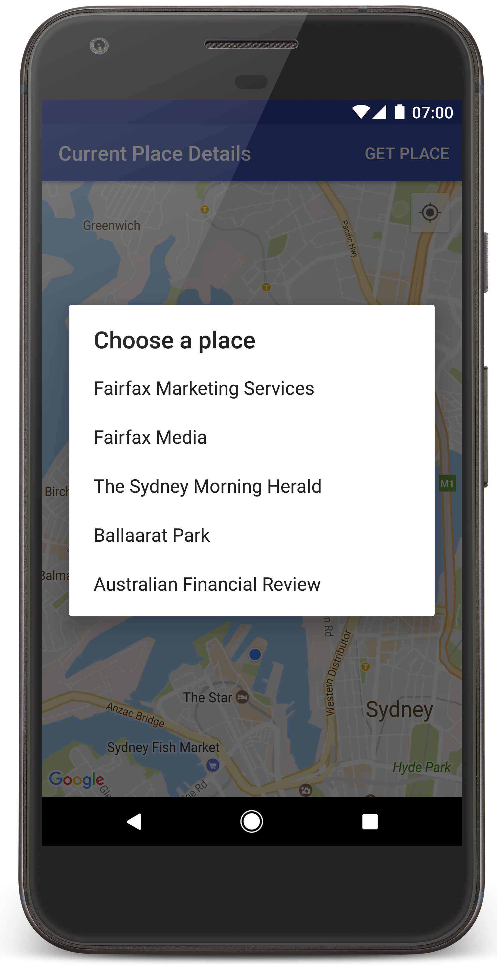
Android Studio richiama Gradle per creare l'app, quindi la esegue sul dispositivo o sull'emulatore. Dovresti visualizzare una mappa con una serie di indicatori al centro della tua posizione corrente, simile all'immagine in questa pagina.
- Seleziona Trova luogo per aprire un elenco di luoghi (un'attività o un altro punto d'interesse). vicino alla tua posizione attuale.
- Seleziona un luogo dall'elenco. Viene aggiunto un indicatore alla mappa per il luogo selezionato.
Risoluzione dei problemi:
- Se non vedi una mappa, verifica di aver ottenuto una chiave API e di averla aggiunta all'app, come descritto sopra. Controlla l'accesso Android Studio Android Monitora i messaggi di errore relativi alla chiave API.
- Se la mappa mostra un singolo indicatore sul Sydney Harbour Bridge (la località predefinita specificata nell'app), verifica di aver concesso autorizzazione di accesso alla posizione per l'app. L'app richiede l'autorizzazione di accesso alla posizione in fase di esecuzione, seguendo il pattern descritto Android guida alle autorizzazioni. Tieni presente che puoi anche impostare le autorizzazioni direttamente sul dispositivo, scegliendo Impostazioni > App > nome app > Autorizzazioni > Posizione. Per maggiori dettagli su come gestire le autorizzazioni in il tuo codice, consulta la guida di seguito per richiedere autorizzazione di accesso alla posizione nella tua app.
- Utilizza la Android Strumenti di debug di Studio per visualizzare i log ed eseguire il debug dell'app.
comprendi il codice
Questa parte del tutorial illustra le parti più significative del CurrentPlaceDetailsOnMap, per aiutarvi a capire come usare creare un'app simile.
Creare un'istanza per il client API Places
Questi oggetti sono i punti di ingresso principali a Places SDK per Android:
- La
Placescrea e gestisce i client per Places SDK for Android. - La
PlacesClientrecupera la posizione corrente del dispositivo e i luoghi nelle vicinanze.
I LocationServices è il punto di accesso principale ai servizi di geolocalizzazione di Android.
Per utilizzare le API, segui questi passaggi nella
onCreate()
del frammento o dell'attività:
- Inizializza un oggetto
Places. - Crea un oggetto
PlacesClient. - Crea un oggetto
FusedLocationProviderClient.
Ad esempio:
Java
@Override
protected void onCreate(Bundle savedInstanceState) {
    super.onCreate(savedInstanceState);

    // ...

    // Retrieve the content view that renders the map.
    setContentView(R.layout.activity_maps);

    // Construct a PlacesClient
    Places.initialize(getApplicationContext(), getString(R.string.maps_api_key));
    placesClient = Places.createClient(this);

    // Construct a FusedLocationProviderClient.
    fusedLocationProviderClient = LocationServices.getFusedLocationProviderClient(this);
}
Kotlin
override fun onCreate(savedInstanceState: Bundle?) {
    super.onCreate(savedInstanceState)

    // ...

    // Retrieve the content view that renders the map.
    setContentView(R.layout.activity_maps)

    // Construct a PlacesClient
    Places.initialize(applicationContext, getString(R.string.maps_api_key))
    placesClient = Places.createClient(this)

    // Construct a FusedLocationProviderClient.
    fusedLocationProviderClient = LocationServices.getFusedLocationProviderClient(this)

}
Richiedi autorizzazione di accesso alla posizione
Per poter stabilire il tipo di accesso, la tua app deve richiedere l'autorizzazione di accesso alla posizione posizione del dispositivo e consentire all'utente di toccare l'icona La mia posizione. pulsante sulla mappa.
Questo tutorial fornisce il codice necessario per richiedere l'autorizzazione di accesso alla posizione precisa. Per ulteriori dettagli, consulta la guida Android autorizzazioni.
Aggiungi l'autorizzazione come autorizzazione secondaria di
<manifest>nel file manifest Android:<manifest xmlns:android="http://schemas.android.com/apk/res/android" package="com.example.currentplacedetailsonmap"> <uses-permission android:name="android.permission.ACCESS_FINE_LOCATION" /> </manifest>Richiedi le autorizzazioni di runtime nella tua app, in modo da concedere all'utente l'opportunità di consentire o negare l'autorizzazione di accesso alla posizione. I seguenti controlli del codice se l'utente ha concesso l'autorizzazione di accesso alla posizione precisa. In caso contrario, richiede l'autorizzazione:
Java
private void getLocationPermission() { /* * Request location permission, so that we can get the location of the * device. The result of the permission request is handled by a callback, * onRequestPermissionsResult. */ if (ContextCompat.checkSelfPermission(this.getApplicationContext(), android.Manifest.permission.ACCESS_FINE_LOCATION) == PackageManager.PERMISSION_GRANTED) { locationPermissionGranted = true; } else { ActivityCompat.requestPermissions(this, new String[]{android.Manifest.permission.ACCESS_FINE_LOCATION}, PERMISSIONS_REQUEST_ACCESS_FINE_LOCATION); } }Kotlin
private fun getLocationPermission() { /* * Request location permission, so that we can get the location of the * device. The result of the permission request is handled by a callback, * onRequestPermissionsResult. */ if (ContextCompat.checkSelfPermission(this.applicationContext, Manifest.permission.ACCESS_FINE_LOCATION) == PackageManager.PERMISSION_GRANTED) { locationPermissionGranted = true } else { ActivityCompat.requestPermissions(this, arrayOf(Manifest.permission.ACCESS_FINE_LOCATION), PERMISSIONS_REQUEST_ACCESS_FINE_LOCATION) } }Esegui l'override del callback
onRequestPermissionsResult()per Gestire il risultato della richiesta di autorizzazione:Java
@Override public void onRequestPermissionsResult(int requestCode, @NonNull String[] permissions, @NonNull int[] grantResults) { locationPermissionGranted = false; if (requestCode == PERMISSIONS_REQUEST_ACCESS_FINE_LOCATION) {// If request is cancelled, the result arrays are empty. if (grantResults.length > 0 && grantResults[0] == PackageManager.PERMISSION_GRANTED) { locationPermissionGranted = true; } } else { super.onRequestPermissionsResult(requestCode, permissions, grantResults); } updateLocationUI(); }Kotlin
override fun onRequestPermissionsResult(requestCode: Int, permissions: Array<String>, grantResults: IntArray) { locationPermissionGranted = false when (requestCode) { PERMISSIONS_REQUEST_ACCESS_FINE_LOCATION -> { // If request is cancelled, the result arrays are empty. if (grantResults.isNotEmpty() && grantResults[0] == PackageManager.PERMISSION_GRANTED) { locationPermissionGranted = true } } else -> super.onRequestPermissionsResult(requestCode, permissions, grantResults) } updateLocationUI() }Una sezione successiva di questo tutorial descrive
updateLocationUI().
Aggiungi una mappa
Visualizzare una mappa utilizzando Maps SDK for Android.
Aggiungi un elemento
<fragment>al layout della tua attività file,activity_maps.xml. Questo elemento definisceSupportMapFragmentagire da container per la mappa e fornire accessoGoogleMapoggetto. Il tutorial utilizza la libreria di supporto Android del frammento di mappa, per garantire la compatibilità con le versioni precedenti del framework Android.<!-- Copyright 2020 Google LLC Licensed under the Apache License, Version 2.0 (the "License"); you may not use this file except in compliance with the License. You may obtain a copy of the License at http://www.apache.org/licenses/LICENSE-2.0 Unless required by applicable law or agreed to in writing, software distributed under the License is distributed on an "AS IS" BASIS, WITHOUT WARRANTIES OR CONDITIONS OF ANY KIND, either express or implied. See the License for the specific language governing permissions and limitations under the License. --> <fragment xmlns:android="http://schemas.android.com/apk/res/android" xmlns:tools="http://schemas.android.com/tools" android:id="@+id/map" android:name="com.google.android.gms.maps.SupportMapFragment" android:layout_width="match_parent" android:layout_height="match_parent" tools:context="com.example.currentplacedetailsonmap.MapsActivityCurrentPlace" />Imposta il file di layout nel metodo
onCreate()dell'attività visualizzazione dei contenuti:Java
@Override protected void onCreate(Bundle savedInstanceState) { super.onCreate(savedInstanceState); // Retrieve the content view that renders the map. setContentView(R.layout.activity_maps); }Kotlin
override fun onCreate(savedInstanceState: Bundle?) { super.onCreate(savedInstanceState) // Retrieve the content view that renders the map. setContentView(R.layout.activity_maps) }Implementa il
OnMapReadyCallbacked eseguire l'override del metodoonMapReady(), per impostare viene mappata quando l'oggettoGoogleMapè disponibile:Java
@Override public void onMapReady(GoogleMap map) { this.map = map; // ... // Turn on the My Location layer and the related control on the map. updateLocationUI(); // Get the current location of the device and set the position of the map. getDeviceLocation(); }Kotlin
override fun onMapReady(map: GoogleMap) { this.map = map // ... // Turn on the My Location layer and the related control on the map. updateLocationUI() // Get the current location of the device and set the position of the map. getDeviceLocation() }Nel metodo
onCreate()della tua attività, ottieni un handle per il frammento della mappa richiamandoFragmentManager.findFragmentById()Quindi utilizzagetMapAsync()per registrarti al callback della mappa:Java
SupportMapFragment mapFragment = (SupportMapFragment) getSupportFragmentManager() .findFragmentById(R.id.map); mapFragment.getMapAsync(this);Kotlin
val mapFragment = supportFragmentManager .findFragmentById(R.id.map) as SupportMapFragment? mapFragment?.getMapAsync(this)Scrivi un metodo
updateLocationUI()per impostare la località i controlli sulla mappa. Se l'utente ha concesso l'autorizzazione di accesso alla posizione, attiva la Il livello La mia posizione e il relativo controllo sulla mappa, altrimenti disattiva il il livello e il controllo e imposta la posizione corrente su null:Java
private void updateLocationUI() { if (map == null) { return; } try { if (locationPermissionGranted) { map.setMyLocationEnabled(true); map.getUiSettings().setMyLocationButtonEnabled(true); } else { map.setMyLocationEnabled(false); map.getUiSettings().setMyLocationButtonEnabled(false); lastKnownLocation = null; getLocationPermission(); } } catch (SecurityException e) { Log.e("Exception: %s", e.getMessage()); } }Kotlin
@SuppressLint("MissingPermission") private fun updateLocationUI() { if (map == null) { return } try { if (locationPermissionGranted) { map?.isMyLocationEnabled = true map?.uiSettings?.isMyLocationButtonEnabled = true } else { map?.isMyLocationEnabled = false map?.uiSettings?.isMyLocationButtonEnabled = false lastKnownLocation = null getLocationPermission() } } catch (e: SecurityException) { Log.e("Exception: %s", e.message, e) } }
Ottieni la posizione del dispositivo Android e posiziona la mappa
Usa il fornitore di servizi di posizione integrato per trovare l'ultima posizione nota del dispositivo. poi usa quella posizione per posizionare la mappa. Il tutorial fornisce il codice necessaria. Per ulteriori dettagli su come individuare la posizione del dispositivo, consulta la guida alle fusa del fornitore di servizi di localizzazione nelle API di geolocalizzazione di Google Play Services.
Java
private void getDeviceLocation() {
/*
* Get the best and most recent location of the device, which may be null in rare
* cases when a location is not available.
*/
try {
if (locationPermissionGranted) {
Task<Location> locationResult = fusedLocationProviderClient.getLastLocation();
locationResult.addOnCompleteListener(this, new OnCompleteListener<Location>() {
@Override
public void onComplete(@NonNull Task<Location> task) {
if (task.isSuccessful()) {
// Set the map's camera position to the current location of the device.
lastKnownLocation = task.getResult();
if (lastKnownLocation != null) {
map.moveCamera(CameraUpdateFactory.newLatLngZoom(
new LatLng(lastKnownLocation.getLatitude(),
lastKnownLocation.getLongitude()), DEFAULT_ZOOM));
}
} else {
Log.d(TAG, "Current location is null. Using defaults.");
Log.e(TAG, "Exception: %s", task.getException());
map.moveCamera(CameraUpdateFactory
.newLatLngZoom(defaultLocation, DEFAULT_ZOOM));
map.getUiSettings().setMyLocationButtonEnabled(false);
}
}
});
}
} catch (SecurityException e) {
Log.e("Exception: %s", e.getMessage(), e);
}
}
Kotlin
@SuppressLint("MissingPermission")
private fun getDeviceLocation() {
/*
* Get the best and most recent location of the device, which may be null in rare
* cases when a location is not available.
*/
try {
if (locationPermissionGranted) {
val locationResult = fusedLocationProviderClient.lastLocation
locationResult.addOnCompleteListener(this) { task ->
if (task.isSuccessful) {
// Set the map's camera position to the current location of the device.
lastKnownLocation = task.result
if (lastKnownLocation != null) {
map?.moveCamera(CameraUpdateFactory.newLatLngZoom(
LatLng(lastKnownLocation!!.latitude,
lastKnownLocation!!.longitude), DEFAULT_ZOOM.toFloat()))
}
} else {
Log.d(TAG, "Current location is null. Using defaults.")
Log.e(TAG, "Exception: %s", task.exception)
map?.moveCamera(CameraUpdateFactory
.newLatLngZoom(defaultLocation, DEFAULT_ZOOM.toFloat()))
map?.uiSettings?.isMyLocationButtonEnabled = false
}
}
}
} catch (e: SecurityException) {
Log.e("Exception: %s", e.message, e)
}
}
Visualizza il luogo attuale
Utilizza Places SDK per Android per ottenere un elenco di luoghi probabili nella posizione attuale del dispositivo. In questo contesto, un luogo è un'attività commerciale o altro punto d'interesse.
Questo tutorial mostra il luogo corrente quando l'utente fa clic su un Pulsante Trova luogo. Offre all'utente un elenco di luoghi probabili scegliere, poi aggiungi un indicatore sulla mappa in corrispondenza della posizione posto. Il tutorial fornisce il codice necessario per interagire con SDK Places per Android. Per ulteriori dettagli, consulta la guida trovare il luogo attuale.
- Crea un file di layout (
current_place_menu.xml) per le opzioni ed eseguire l'override del metodoonCreateOptionsMenu()per configurare il menu opzioni. Vedi l'app di esempio associata per il codice. - Sostituisci il metodo
onOptionsItemSelected()per ottenere luogo corrente quando l'utente fa clic sull'opzione Trova luogo:Java
@Override public boolean onOptionsItemSelected(MenuItem item) { if (item.getItemId() == R.id.option_get_place) { showCurrentPlace(); } return true; }Kotlin
override fun onOptionsItemSelected(item: MenuItem): Boolean { if (item.itemId == R.id.option_get_place) { showCurrentPlace() } return true } Crea un metodo
showCurrentPlace()per ottenere un elenco di probabili luoghi nella posizione attuale del dispositivo:Java
private void showCurrentPlace() { if (map == null) { return; } if (locationPermissionGranted) { // Use fields to define the data types to return. List<Place.Field> placeFields = Arrays.asList(Place.Field.NAME, Place.Field.ADDRESS, Place.Field.LAT_LNG); // Use the builder to create a FindCurrentPlaceRequest. FindCurrentPlaceRequest request = FindCurrentPlaceRequest.newInstance(placeFields); // Get the likely places - that is, the businesses and other points of interest that // are the best match for the device's current location. @SuppressWarnings("MissingPermission") final Task<FindCurrentPlaceResponse> placeResult = placesClient.findCurrentPlace(request); placeResult.addOnCompleteListener (new OnCompleteListener<FindCurrentPlaceResponse>() { @Override public void onComplete(@NonNull Task<FindCurrentPlaceResponse> task) { if (task.isSuccessful() && task.getResult() != null) { FindCurrentPlaceResponse likelyPlaces = task.getResult(); // Set the count, handling cases where less than 5 entries are returned. int count; if (likelyPlaces.getPlaceLikelihoods().size() < M_MAX_ENTRIES) { count = likelyPlaces.getPlaceLikelihoods().size(); } else { count = M_MAX_ENTRIES; } int i = 0; likelyPlaceNames = new String[count]; likelyPlaceAddresses = new String[count]; likelyPlaceAttributions = new List[count]; likelyPlaceLatLngs = new LatLng[count]; for (PlaceLikelihood placeLikelihood : likelyPlaces.getPlaceLikelihoods()) { // Build a list of likely places to show the user. likelyPlaceNames[i] = placeLikelihood.getPlace().getName(); likelyPlaceAddresses[i] = placeLikelihood.getPlace().getAddress(); likelyPlaceAttributions[i] = placeLikelihood.getPlace() .getAttributions(); likelyPlaceLatLngs[i] = placeLikelihood.getPlace().getLatLng(); i++; if (i > (count - 1)) { break; } } // Show a dialog offering the user the list of likely places, and add a // marker at the selected place. MapsActivityCurrentPlace.this.openPlacesDialog(); } else { Log.e(TAG, "Exception: %s", task.getException()); } } }); } else { // The user has not granted permission. Log.i(TAG, "The user did not grant location permission."); // Add a default marker, because the user hasn't selected a place. map.addMarker(new MarkerOptions() .title(getString(R.string.default_info_title)) .position(defaultLocation) .snippet(getString(R.string.default_info_snippet))); // Prompt the user for permission. getLocationPermission(); } }Kotlin
@SuppressLint("MissingPermission") private fun showCurrentPlace() { if (map == null) { return } if (locationPermissionGranted) { // Use fields to define the data types to return. val placeFields = listOf(Place.Field.NAME, Place.Field.ADDRESS, Place.Field.LAT_LNG) // Use the builder to create a FindCurrentPlaceRequest. val request = FindCurrentPlaceRequest.newInstance(placeFields) // Get the likely places - that is, the businesses and other points of interest that // are the best match for the device's current location. val placeResult = placesClient.findCurrentPlace(request) placeResult.addOnCompleteListener { task -> if (task.isSuccessful && task.result != null) { val likelyPlaces = task.result // Set the count, handling cases where less than 5 entries are returned. val count = if (likelyPlaces != null && likelyPlaces.placeLikelihoods.size < M_MAX_ENTRIES) { likelyPlaces.placeLikelihoods.size } else { M_MAX_ENTRIES } var i = 0 likelyPlaceNames = arrayOfNulls(count) likelyPlaceAddresses = arrayOfNulls(count) likelyPlaceAttributions = arrayOfNulls<List<*>?>(count) likelyPlaceLatLngs = arrayOfNulls(count) for (placeLikelihood in likelyPlaces?.placeLikelihoods ?: emptyList()) { // Build a list of likely places to show the user. likelyPlaceNames[i] = placeLikelihood.place.name likelyPlaceAddresses[i] = placeLikelihood.place.address likelyPlaceAttributions[i] = placeLikelihood.place.attributions likelyPlaceLatLngs[i] = placeLikelihood.place.latLng i++ if (i > count - 1) { break } } // Show a dialog offering the user the list of likely places, and add a // marker at the selected place. openPlacesDialog() } else { Log.e(TAG, "Exception: %s", task.exception) } } } else { // The user has not granted permission. Log.i(TAG, "The user did not grant location permission.") // Add a default marker, because the user hasn't selected a place. map?.addMarker(MarkerOptions() .title(getString(R.string.default_info_title)) .position(defaultLocation) .snippet(getString(R.string.default_info_snippet))) // Prompt the user for permission. getLocationPermission() } }Crea un metodo
openPlacesDialog()per visualizzare un modulo consentendo all'utente di selezionare un luogo da un elenco di luoghi probabili. Aggiungi un indicatore sulla mappa per il luogo selezionato. I contenuti dell'indicatore includono nome e indirizzo del luogo ed eventuali attribuzioni fornite dall'API:Java
private void openPlacesDialog() { // Ask the user to choose the place where they are now. DialogInterface.OnClickListener listener = new DialogInterface.OnClickListener() { @Override public void onClick(DialogInterface dialog, int which) { // The "which" argument contains the position of the selected item. LatLng markerLatLng = likelyPlaceLatLngs[which]; String markerSnippet = likelyPlaceAddresses[which]; if (likelyPlaceAttributions[which] != null) { markerSnippet = markerSnippet + "\n" + likelyPlaceAttributions[which]; } // Add a marker for the selected place, with an info window // showing information about that place. map.addMarker(new MarkerOptions() .title(likelyPlaceNames[which]) .position(markerLatLng) .snippet(markerSnippet)); // Position the map's camera at the location of the marker. map.moveCamera(CameraUpdateFactory.newLatLngZoom(markerLatLng, DEFAULT_ZOOM)); } }; // Display the dialog. AlertDialog dialog = new AlertDialog.Builder(this) .setTitle(R.string.pick_place) .setItems(likelyPlaceNames, listener) .show(); }Kotlin
private fun openPlacesDialog() { // Ask the user to choose the place where they are now. val listener = DialogInterface.OnClickListener { dialog, which -> // The "which" argument contains the position of the selected item. val markerLatLng = likelyPlaceLatLngs[which] var markerSnippet = likelyPlaceAddresses[which] if (likelyPlaceAttributions[which] != null) { markerSnippet = """ $markerSnippet ${likelyPlaceAttributions[which]} """.trimIndent() } if (markerLatLng == null) { return@OnClickListener } // Add a marker for the selected place, with an info window // showing information about that place. map?.addMarker(MarkerOptions() .title(likelyPlaceNames[which]) .position(markerLatLng) .snippet(markerSnippet)) // Position the map's camera at the location of the marker. map?.moveCamera(CameraUpdateFactory.newLatLngZoom(markerLatLng, DEFAULT_ZOOM.toFloat())) } // Display the dialog. AlertDialog.Builder(this) .setTitle(R.string.pick_place) .setItems(likelyPlaceNames, listener) .show() }Crea un layout personalizzato per i contenuti della finestra informativa. Ciò rende possibile visualizzare più righe di contenuti nella finestra informativa. Per prima cosa, aggiungi un file di layout XML,
custom_info_contents.xml, contenente un file di testo per il titolo della finestra informativa e un'altra visualizzazione di testo per lo snippet (che è il contenuto testuale della finestra informativa):<?xml version="1.0" encoding="utf-8"?> <!-- Copyright 2020 Google LLC Licensed under the Apache License, Version 2.0 (the "License"); you may not use this file except in compliance with the License. You may obtain a copy of the License at http://www.apache.org/licenses/LICENSE-2.0 Unless required by applicable law or agreed to in writing, software distributed under the License is distributed on an "AS IS" BASIS, WITHOUT WARRANTIES OR CONDITIONS OF ANY KIND, either express or implied. See the License for the specific language governing permissions and limitations under the License. --> <LinearLayout xmlns:android="http://schemas.android.com/apk/res/android" android:layout_width="wrap_content" android:layout_height="wrap_content" android:layoutDirection="locale" android:orientation="vertical"> <TextView android:id="@+id/title" android:layout_width="wrap_content" android:layout_height="wrap_content" android:layout_gravity="center_horizontal" android:textColor="#ff000000" android:textStyle="bold" /> <TextView android:id="@+id/snippet" android:layout_width="wrap_content" android:layout_height="wrap_content" android:textColor="#ff7f7f7f" /> </LinearLayout>Implementa il
InfoWindowAdapterper gonfiare il layout e caricare i contenuti della finestra informativa:Java
// Use a custom info window adapter to handle multiple lines of text in the // info window contents. this.map.setInfoWindowAdapter(new GoogleMap.InfoWindowAdapter() { @Override // Return null here, so that getInfoContents() is called next. public View getInfoWindow(Marker arg0) { return null; } @Override public View getInfoContents(Marker marker) { // Inflate the layouts for the info window, title and snippet. View infoWindow = getLayoutInflater().inflate(R.layout.custom_info_contents, (FrameLayout) findViewById(R.id.map), false); TextView title = infoWindow.findViewById(R.id.title); title.setText(marker.getTitle()); TextView snippet = infoWindow.findViewById(R.id.snippet); snippet.setText(marker.getSnippet()); return infoWindow; } });Kotlin
// Use a custom info window adapter to handle multiple lines of text in the // info window contents. this.map?.setInfoWindowAdapter(object : InfoWindowAdapter { // Return null here, so that getInfoContents() is called next. override fun getInfoWindow(arg0: Marker): View? { return null } override fun getInfoContents(marker: Marker): View { // Inflate the layouts for the info window, title and snippet. val infoWindow = layoutInflater.inflate(R.layout.custom_info_contents, findViewById<FrameLayout>(R.id.map), false) val title = infoWindow.findViewById<TextView>(R.id.title) title.text = marker.title val snippet = infoWindow.findViewById<TextView>(R.id.snippet) snippet.text = marker.snippet return infoWindow } })
Salva lo stato della mappa
Salva la posizione della fotocamera della mappa e la posizione del dispositivo. Quando un utente ruota un dispositivo Android, o apportare modifiche alla configurazione, il framework Android distrugge e ricrea l'attività sulla mappa. Per garantire un'esperienza utente senza problemi, è consigliabile archiviare lo stato pertinente dell'applicazione e ripristinarlo quando necessario.
Questo tutorial fornisce tutto il codice necessario per salvare lo stato della mappa. Per
per altri dettagli, consulta la guida
savedInstanceState
un bundle.
Nell'attività sulla mappa, configura le coppie chiave-valore per l'archiviazione dello stato dell'attività:
Java
private static final String KEY_CAMERA_POSITION = "camera_position"; private static final String KEY_LOCATION = "location";
Kotlin
private const val KEY_CAMERA_POSITION = "camera_position" private const val KEY_LOCATION = "location"
Implementa il callback
onSaveInstanceState()per salvare lo stato in cui l'attività viene sospesa:Java
@Override protected void onSaveInstanceState(Bundle outState) { if (map != null) { outState.putParcelable(KEY_CAMERA_POSITION, map.getCameraPosition()); outState.putParcelable(KEY_LOCATION, lastKnownLocation); } super.onSaveInstanceState(outState); }Kotlin
override fun onSaveInstanceState(outState: Bundle) { map?.let { map -> outState.putParcelable(KEY_CAMERA_POSITION, map.cameraPosition) outState.putParcelable(KEY_LOCATION, lastKnownLocation) } super.onSaveInstanceState(outState) }Nel metodo
onCreate()dell'attività, recupera il posizione del dispositivo e posizione della fotocamera della mappa, se precedentemente salvate:Java
// Retrieve location and camera position from saved instance state. if (savedInstanceState != null) { lastKnownLocation = savedInstanceState.getParcelable(KEY_LOCATION); cameraPosition = savedInstanceState.getParcelable(KEY_CAMERA_POSITION); }Kotlin
if (savedInstanceState != null) { lastKnownLocation = savedInstanceState.getParcelable(KEY_LOCATION) cameraPosition = savedInstanceState.getParcelable(KEY_CAMERA_POSITION) }