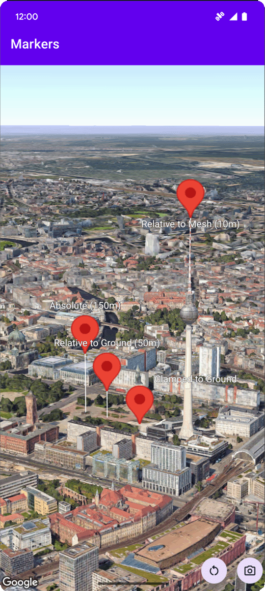
মার্কার উচ্চতা কনফিগার করুন
সেভ করা পৃষ্ঠা গুছিয়ে রাখতে 'সংগ্রহ' ব্যবহার করুন
আপনার পছন্দ অনুযায়ী কন্টেন্ট সেভ করুন ও সঠিক বিভাগে রাখুন।
প্ল্যাটফর্ম নির্বাচন করুন: Android iOS 
আপনি নিম্নলিখিত মানগুলির মধ্যে একটিতে altitudeMode
বৈশিষ্ট্য সেট করে একটি চিহ্নিতকারীর উচ্চতা সেট করতে পারেন:
-
ABSOLUTE
-
RELATIVE_TO_GROUND
-
CLAMP_TO_GROUND
-
RELATIVE_TO_MESH
নিম্নলিখিত কোড নমুনা প্রতিটি পদ্ধতি ব্যবহার কিভাবে প্রদর্শন করে. এই কোড নমুনাটি ব্যবহার করতে, সেটআপে নির্দেশাবলী অনুসরণ করুন এবং একটি মৌলিক 3D মানচিত্রের সাথে আপনার Android স্টুডিও প্রকল্প সেট আপ করতে আপনার অ্যাপে একটি 3D মানচিত্র যোগ করুন । তারপর, MainActivity.kt
ফাইলে নিম্নলিখিত কোড যোগ করুন:
// Add imports
import com.google.android.gms.maps3d.model.latLngAltitude
...
// Add to the onMap3DViewReady method, after the googleMap3D object has been initialized
googleMap3D.setMapMode(Map3DMode.SATELLITE)
googleMap3D.setCamera(
camera {
center = latLngAltitude {
latitude = 52.51974795
longitude = 13.40715553
altitude = 150.0
}
heading = 252.7
tilt = 79.0
range = 1500.0
}
)
// Marker 1: Absolute
googleMap3D.addMarker(markerOptions {
position = latLngAltitude {
latitude = 52.519605780912585
longitude = 13.406867190588198
altitude = 150.0
}
label = "Absolute (150m)"
altitudeMode = AltitudeMode.ABSOLUTE
isExtruded = true
isDrawnWhenOccluded = true
collisionBehavior = CollisionBehavior.REQUIRED_AND_HIDES_OPTIONAL
})
// Marker 2: Relative to Ground
googleMap3D.addMarker(markerOptions {
position = latLngAltitude {
latitude = 52.519882191069016
longitude = 13.407410777254293
altitude = 50.0
}
label = "Relative to Ground (50m)"
altitudeMode = AltitudeMode.RELATIVE_TO_GROUND
isExtruded = true
isDrawnWhenOccluded = true
})
// Marker 3: Clamped to Ground
googleMap3D.addMarker(markerOptions {
position = latLngAltitude {
latitude = 52.52027645136134
longitude = 13.408271658592406
altitude = 0.0 // altitude is effectively ignored by CLAMP_TO_GROUND for rendering,
// but might be relevant if you read the marker's position later.
// For CLAMP_TO_GROUND, it's often set to 0.0.
}
label = "Clamped to Ground"
altitudeMode = AltitudeMode.CLAMP_TO_GROUND
isExtruded = true
isDrawnWhenOccluded = true
})
// Marker 4: Relative to Mesh
googleMap3D.addMarker(markerOptions {
position = latLngAltitude {
latitude = 52.520835071144226
longitude = 13.409426847943774
altitude = 10.0 // Altitude relative to 3D mesh (buildings, terrain features)
}
label = "Relative to Mesh (10m)"
altitudeMode = AltitudeMode.RELATIVE_TO_MESH
isExtruded = true
isDrawnWhenOccluded = true
})
অন্য কিছু উল্লেখ না করা থাকলে, এই পৃষ্ঠার কন্টেন্ট Creative Commons Attribution 4.0 License-এর অধীনে এবং কোডের নমুনাগুলি Apache 2.0 License-এর অধীনে লাইসেন্স প্রাপ্ত। আরও জানতে, Google Developers সাইট নীতি দেখুন। Java হল Oracle এবং/অথবা তার অ্যাফিলিয়েট সংস্থার রেজিস্টার্ড ট্রেডমার্ক।
2025-08-29 UTC-তে শেষবার আপডেট করা হয়েছে।
[null,null,["2025-08-29 UTC-তে শেষবার আপডেট করা হয়েছে।"],[],[],null,["# Configure marker altitude\n\nSelect platform: [Android](/maps/documentation/maps-3d/android-sdk/configure-marker-altitude \"View this page for the Android platform docs.\") [iOS](/maps/documentation/maps-3d/ios-sdk/configure-marker-altitude \"View this page for the iOS platform docs.\")\n\n\u003cbr /\u003e\n\n| This product or feature is Experimental (pre-GA). Pre-GA products and features might have limited support, and changes to pre-GA products and features might not be compatible with other pre-GA versions. Pre-GA Offerings are covered by the [Google\n| Maps Platform Service Specific Terms](https://cloud.google.com/maps-platform/terms/maps-service-terms). For more information, see the [launch stage descriptions](/maps/launch-stages).\n\n\nYou can set a marker's altitude by setting the\n[`altitudeMode`](/maps/documentation/maps-3d/android-sdk/reference/com/google/android/gms/maps3d/model/MarkerOptions#altitudeMode())\nproperty to one of the\nfollowing values:\n\n- `ABSOLUTE`\n- `RELATIVE_TO_GROUND`\n- `CLAMP_TO_GROUND`\n- `RELATIVE_TO_MESH`\n\nThe following code sample\ndemonstrates how to use each of the methods. To use this code sample, follow the instructions in\n[Setup](/maps/documentation/maps-3d/android-sdk/setup) and\n[Add a 3D map to your app](/maps/documentation/maps-3d/android-sdk/add-a-3d-map) to set\nup your Android Studio project with a basic 3D map. Then, add the following code to the\n**`MainActivity.kt`** file: \n\n```kotlin\n // Add imports\n import com.google.android.gms.maps3d.model.latLngAltitude\n \n ...\n \n // Add to the onMap3DViewReady method, after the googleMap3D object has been initialized\n googleMap3D.setMapMode(Map3DMode.SATELLITE)\n \n googleMap3D.setCamera(\n camera {\n center = latLngAltitude {\n latitude = 52.51974795\n longitude = 13.40715553\n altitude = 150.0\n }\n heading = 252.7\n tilt = 79.0\n range = 1500.0\n }\n )\n \n \n // Marker 1: Absolute\n googleMap3D.addMarker(markerOptions {\n position = latLngAltitude {\n latitude = 52.519605780912585\n longitude = 13.406867190588198\n altitude = 150.0\n }\n label = \"Absolute (150m)\"\n altitudeMode = AltitudeMode.ABSOLUTE\n isExtruded = true\n isDrawnWhenOccluded = true\n collisionBehavior = CollisionBehavior.REQUIRED_AND_HIDES_OPTIONAL\n })\n \n // Marker 2: Relative to Ground\n googleMap3D.addMarker(markerOptions {\n position = latLngAltitude {\n latitude = 52.519882191069016\n longitude = 13.407410777254293\n altitude = 50.0\n }\n label = \"Relative to Ground (50m)\"\n altitudeMode = AltitudeMode.RELATIVE_TO_GROUND\n isExtruded = true\n isDrawnWhenOccluded = true\n })\n \n // Marker 3: Clamped to Ground\n googleMap3D.addMarker(markerOptions {\n position = latLngAltitude {\n latitude = 52.52027645136134\n longitude = 13.408271658592406\n altitude = 0.0 // altitude is effectively ignored by CLAMP_TO_GROUND for rendering,\n // but might be relevant if you read the marker's position later.\n // For CLAMP_TO_GROUND, it's often set to 0.0.\n }\n label = \"Clamped to Ground\"\n altitudeMode = AltitudeMode.CLAMP_TO_GROUND\n isExtruded = true\n isDrawnWhenOccluded = true\n })\n \n // Marker 4: Relative to Mesh\n googleMap3D.addMarker(markerOptions {\n position = latLngAltitude {\n latitude = 52.520835071144226\n longitude = 13.409426847943774\n altitude = 10.0 // Altitude relative to 3D mesh (buildings, terrain features)\n }\n label = \"Relative to Mesh (10m)\"\n altitudeMode = AltitudeMode.RELATIVE_TO_MESH\n isExtruded = true\n isDrawnWhenOccluded = true\n })\n \n \n```"]]