Éléments que vous pouvez personnaliser sur la carte
Restez organisé à l'aide des collections
Enregistrez et classez les contenus selon vos préférences.
Les éléments cartographiques que vous pouvez personnaliser sont organisés selon une hiérarchie, et chaque élément cartographique possède un ou plusieurs éléments de style que vous pouvez personnaliser. La plupart des éléments cartographiques de niveau supérieur ont un ou plusieurs éléments enfants. Vous disposez de plusieurs options pour personnaliser les styles de carte :
Hériter du style de carte de base : si vous ne personnalisez pas un élément de style pour un élément cartographique, il hérite du style par défaut de la carte de base.
Hériter des parents : personnalisez un élément de style sur un élément cartographique parent afin que tous les éléments enfants non personnalisés ci-dessous héritent des styles de leur parent.
Remplacer le style parent : personnalisez un élément de style sur un élément cartographique de carte enfant pour remplacer le style parent de cet élément.
Personnaliser les niveaux de zoom : pour certains éléments cartographiques, vous pouvez personnaliser les éléments de style selon différents niveaux de zoom. Pour en savoir plus, consultez Appliquer un style aux niveaux de zoom.
Comment appliquer un style pour chaque élément cartographique
Les éléments cartographiques peuvent être associés à un ou plusieurs des éléments de style suivants, que vous pouvez personnaliser selon le type d'élément cartographique :
Couleur de remplissage : couleur de remplissage des polygones et des polylignes.
Couleur du trait : couleur du contour des polygones et des polylignes.
Épaisseur du trait : épaisseur du contour des polygones et des polylignes.
Vous ne devez pas la définir sur 0. Si vous ne souhaitez pas de contour, choisissez la même couleur pour le trait et le remplissage.
Couleur de l'icône : couleur de remplissage des icônes.
Couleur de remplissage du texte : couleur de remplissage des libellés de texte.
Couleur du trait du texte : couleur du contour des libellés de texte.
Afficher ou masquer les éléments cartographiques
Si vous souhaitez afficher ou masquer des éléments cartographiques sur votre carte, utilisez l'élément de style Visibilité :
Dans l'éditeur de style, sélectionnez l'élément cartographique.
Pour afficher l'élément cartographique sur la carte : sous Visibilité, sélectionnez Activé. Pour supprimer un élément cartographique : sous Visibilité, sélectionnez Désactivé.
Polygones et polylignes
Pour les types d'éléments cartographiques représentés par une forme (par exemple, "Plage", "Pays" et "Place publique") ou par une ligne (comme une voie ferrée, une autoroute ou un sentier), vous pouvez généralement appliquer un style aux éléments suivants : visibilité, couleur de remplissage, couleur du trait et épaisseur du trait.
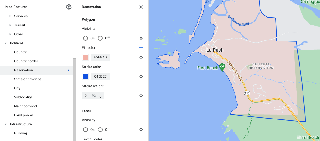
Exemple de personnalisation du style de polygone (pour le type d'élément cartographique Réserve)
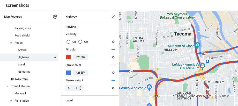
Exemple de personnalisation du style de polyligne (pour le type d'élément cartographique Autoroute)
Icônes et libellés textuels
Pour les types d'éléments cartographiques qui sont entièrement ou partiellement représentés par un libellé, comme les points d'intérêt ou les transports, vous pouvez généralement appliquer un style aux éléments suivants : visibilité, couleur de l'icône, couleur de remplissage du texte et couleur du trait du texte.
Exemple de personnalisation du style pour le texte des libellés et les icônes
Hiérarchie des éléments cartographiques de la carte
Les tableaux ci-dessous présentent les éléments cartographiques enfants disponibles pour chaque élément cartographique de niveau supérieur.
Points d'intérêt
Urgence
Incendie
Hôpital
Pharmacie
Police
Divertissement
Arts
Casino
Cinéma
Historique
Musée
Parc à thème
Attraction touristique
Alimentation et boissons
Bar
Café
Restaurant
Vins
Hébergement
Loisirs
Plage
Bateau
Pêche
Parcours de golf
Source d'eau chaude
Réserve naturelle
Parc
Sommet
Complexe sportif
Terrain de sport
Point de départ d'un sentier
Zoo
Commerce
Courses
Shopping
Services
Distributeur automatique
Banque
Location de voitures
Recharge de VE
Station-service
Parking
Bureau de poste
Aire de repos
Toilettes
Transports en commun
Aéroport
Autre
Pont
Cimetière
Administration
Bibliothèque
Armée
Lieu de culte
École
Place publique
Sauf indication contraire, le contenu de cette page est régi par une licence Creative Commons Attribution 4.0, et les échantillons de code sont régis par une licence Apache 2.0. Pour en savoir plus, consultez les Règles du site Google Developers. Java est une marque déposée d'Oracle et/ou de ses sociétés affiliées.
Dernière mise à jour le 2023/12/26 (UTC).
[null,null,["Dernière mise à jour le 2023/12/26 (UTC)."],[[["\u003cp\u003eCustomize the appearance of Google Maps by styling map features, including their visibility, colors, and outlines.\u003c/p\u003e\n"],["\u003cp\u003eMap features inherit styles from their parent features, but you can override these styles for individual features or zoom levels.\u003c/p\u003e\n"],["\u003cp\u003eChoose to show or hide specific map features using the visibility setting in the style editor.\u003c/p\u003e\n"],["\u003cp\u003eAdjust the styling of shapes and lines, such as polygons and polylines, by changing their fill color, stroke color, and stroke width, although some political features and 3D buildings have limitations.\u003c/p\u003e\n"],["\u003cp\u003eCustomize icons and text labels for points of interest and transportation elements by modifying their colors and outlines.\u003c/p\u003e\n"]]],[],null,["Select platform: [Android](/maps/documentation/android-sdk/cloud-customization/taxonomy \"View this page for the Android platform docs.\") [iOS](/maps/documentation/ios-sdk/cloud-customization/taxonomy \"View this page for the iOS platform docs.\") [JavaScript](/maps/documentation/javascript/cloud-customization/taxonomy \"View this page for the JavaScript platform docs.\") [Web Service](/maps/documentation/maps-static/cloud-customization/taxonomy \"View this page for the Web Service platform docs.\")\n\n\u003cbr /\u003e\n\n\nThe map features you can customize are arranged in a hierarchy, and each map\nfeature has one or more style elements that you can customize. Most top-level\nfeatures have one or more child map features. You have several options when\ncustomizing map styles:\n\n- **Inherit from the base map style**: If you don't customize a style element\n for a map feature, it inherits the default style from the base map.\n\n- **Inherit from parents**: Customize a style element on a parent map feature,\n to have all un-customized child map features below inherit the styles from\n their parent.\n\n- **Override the parent style**: Customize a style element on a child map\n feature to override the parent style for that element.\n\n- **Customize zoom levels** : For some map features, you can customize style\n elements for different zoom levels. For details, see [Style zoom\n levels](/maps/documentation/maps-static/cloud-customization/zoom-levels).\n\nWhat you can style for each map feature\n\nMap features can have one or more of the following style elements that you can\ncustomize, depending on the type of map feature:\n\n- **Visibility**: Whether to show or hide this feature on the map.\n\n- **Fill color**: Fill color for polygons and polylines.\n\n- **Stroke color**: Outline color for polygons and polylines.\n\n- **Stroke width**: Thickness of the outline for polygons and polylines.\n Results may vary depending on the zoom level. If you don't want an outline,\n set the Stroke color to be the same as the Fill color, or set the Stroke\n width to 0.\n\n- **Icon color**: Fill color for the icons.\n\n- **Text fill color**: Fill color for text labels.\n\n- **Text stroke color**: Outline color for text labels.\n\n| **Note:** Stroke color and Stroke width customizations are not available for all map features. For details, see [Polygons and Polylines](#polygons_and_polylines).\n\nMap feature visibility\n\nWhen you hide map features or make them transparent, you may expose boundary\ninaccuracies. Map feature boundaries are not always precise, but are adjusted to\nlook correct when all layers are visible. To learn more about how map layers\naffect each other, see [Manage styles that overlap](/maps/documentation/maps-static/cloud-customization/overlap).\n\nThere are two ways to show or hide map features: visibility and opacity.\n\nVisibility\n\nTo either display or hide a map feature on your map, use the **Visibility**\nstyle element. For more details, see\n[Filter which map features to display](/maps/documentation/maps-static/cloud-customization/viz).\n| **Note:** Not all map features are shown on the map at all zoom levels. To see the map feature displayed or hidden, you may need to zoom in or out.\n\nOpacity\n\nYou can also make a map feature transparent by adjusting the opacity of the\nfollowing style elements: Fill color, Stroke color, Text fill color, and Text\nstroke color. \n\nWhen you adjust the opacity of a map feature, its appearance depends on the map\nfeatures underneath. To avoid unexpected style changes, set a custom style for\nall overlapping features.\n| **Note:** Opacity is not available for all map features.\n\nPolygons and Polylines\n\nFor map feature types that are represented with a shape, such as Beach, Country,\nand Town square, or a line, such as Railway track, Highway, and Trail, you can\ntypically style the following elements: Visibility, Fill color, Stroke color,\nand Stroke width. \n\n*Polygon styling customization example - for **Reservation** feature type*\n\n*Polyline styling customization example - for **Highway** feature type*\n\nStroke color and Stroke width customizations are **not available** for the\nfollowing map features:\n\n- Political map features: Their style conveys meaning on the map, such\n as indicating the type of territory. The political map features are\n **Country** , **Border** , **State or province** , and **Sublocality**.\n\n- 3D style buildings.\n\nIcons and Text Labels\n\nFor map feature types that are fully or partially represented with a label, such\nas Point of interest or Transportation, you can usually style the following\nelements: Visibility, Icon color, Text fill color, and Text stroke color. \n\n*Label text and icon styling customizations example*\n\nMap feature hierarchy\n\nThese tables for the top level map features show what child map features are\navailable under each.\n\n| Point of interest ||\n|----------------|-----------------------------------------------------------------------------------------------------------------|\n| Emergency | Fire Hospital Pharmacy Police |\n| Entertainment | Arts Casino Cinema Historic Museum Theme park Tourist attraction |\n| Food and drink | Bar Cafe Restaurant Winery |\n| Landmark | |\n| Lodging | |\n| Recreation | Beach Boating Fishing Golf course Hot spring Nature reserve Park Peak Sports complex Sports field Trailhead Zoo |\n| Retail | Grocery Shopping |\n| Service | ATM Bank Car rental EV charging Gas station Parking lot Post office Rest stop Restroom |\n| Transit | Airport |\n| Other | Bridge Cemetery Government Library Military Place of worship School Town square |\n\n| Political ||\n|-------------------|---|\n| Country | |\n| Border | |\n| Reservation | |\n| State or province | |\n| City | |\n| Sublocality | |\n| Neighborhood | |\n| Land parcel | |\n\n| Infrastructure ||||\n|-------------------|---------------------|-----------------------------------------|---------------|\n| Building | Commercial | | |\n| Business corridor | | | |\n| Road network | No traffic | Pedestrian mall |\n| Road network | No traffic | Trail | Paved Unpaved |\n| Road network | Parking aisle | | |\n| Road network | Ramp | | |\n| Road network | Road shield | | |\n| Road network | Road sign | | |\n| Road network | Road | Arterial Highway Local No outlet | |\n| Road network | Road detail^\\*^ | Surface Crosswalk Sidewalk Intersection | |\n| Railway track | Commercial Commuter | | |\n| Transit station | Bicycle share | | |\n| Transit station | Bus station | | |\n| Transit station | Ferry terminal | | |\n| Transit station | Funicular station | | |\n| Transit station | Gondola station | | |\n| Transit station | Monorail | | |\n| Transit station | Rail station | Subway station Tram station | |\n| Urban area | | | |\n\n| Natural |||\n|-------------|------------------------|----------------------------------------------|\n| Continent | | |\n| Archipelago | | |\n| Island | | |\n| Land | Land cover^†^ | Crops Dry crops Forest Ice Sand Shrub Tundra |\n| Water | Ocean Lake River Other | |\n| Base | | |"]]