קל לארגן דפים בעזרת אוספים
אפשר לשמור ולסווג תוכן על סמך ההעדפות שלך.
מפתחים באזור הכלכלי האירופי (EEA)
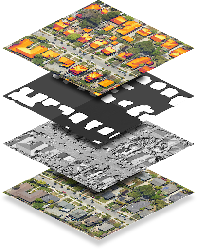
נקודת הקצה dataLayers מחזירה נתונים שמקודדים כקובצי GeoTIFF, שאפשר להשתמש בהם בכל אפליקציית מערכת מידע גיאוגרפי (GIS) כדי לתכנן מערכות סולאריות.
כל מחרוזת בתגובה של dataLayers מכילה כתובת URL, שאפשר להשתמש בה כדי לאחזר את קובץ ה-GeoTIFF המתאים. כתובות ה-URL תקפות למשך שעה לכל היותר אחרי שהן נוצרות מהבקשה המקורית של שכבות הנתונים. אפשר לאחסן קובצי GeoTIFF למשך 30 ימים לכל היותר.
חוץ משכבת ה-RGB, קובצי GeoTIFF לא מוצגים בצורה תקינה בצפייה בתמונות, כי התוכן הוא נתונים מקודדים ולא תמונות RGB. בנוסף, אי אפשר להשתמש ישירות בקובצי GeoTIFF כתמונת שכבת-על עם Maps Javascript API.
בטבלה הבאה מתואר כל אחד מהשכבות בפירוט.
שכבה
עומק הפיקסלים
רזולוציה
תיאור
מודל פני שטח דיגיטלי (DSM)
מספר ממשי (float) ב-32 ביט
0.1 מ' לכל פיקסל
נתוני גובה שמייצגים את הטופוגרפיה של פני כדור הארץ, כולל מאפיינים טבעיים ומבנים. הערכים הם במטרים מעל פני הים. מיקומים לא תקינים או אזורים שאין לנו נתונים לגביהם מאוחסנים כ-9999-.
תצלום אוויר של האזור. קובץ התמונות בפורמט GeoTIFF מכיל שלושה פסי תדרים שמתאימים לערכים אדום, ירוק וכחול, כדי ליצור ערך RGB של 24 ביט לכל פיקסל.
כברירת מחדל, רזולוציית הפיקסלים היא 0.1 מ' לפיקסל.
מסכת בניין
1-bit
0.1 מ' לכל פיקסל
ביט אחד לכל פיקסל שמציין אם הפיקסל נחשב לחלק מגג.
שטף שנתי
מספר ממשי (float) ב-32 ביט
0.1 מ' לכל פיקסל
מפת השטף השנתי, או מפת אור השמש השנתי על הגגות באזור.
הערכים הם קוט"ש/קילוואט/שנה.
שטף הקרינה מחושב לכל מיקום, ולא רק לגגות של מבנים. מיקומים לא חוקיים או אזורים שלא הצלחנו לחשב בהם את השטף מאוחסנים כ-9999-. מיקומים שנמצאים מחוץ לאזור הכיסוי שלנו לא תקינים.
הערה: זהו שטף לא מוסתר.
שינוי חודשי
מספר ממשי (float) ב-32 ביט
0.5 מ' לפיקסל
מפת השטף החודשי (אור השמש על הגגות, מחולק לפי חודש) של האזור. הערכים הם קוט"ש/קילוואט/שנה. קובץ התמונות GeoTIFF מכיל 12 פסים שתואמים לחודשים ינואר עד דצמבר, לפי הסדר.
הצללה לפי שעה
מספר שלם (integer) ב-32 ביט
1 מ'/פיקסל
12 כתובות URL של מפות הצללה לפי שעה, שמתאימות לחודשים ינואר עד דצמבר, לפי הסדר.
כל קובץ GeoTIFF מכיל 24 פסים, שמתאימים ל-24 שעות ביממה. כל פיקסל הוא מספר שלם של 32 ביט, שמתאים ל-31 הימים של אותו חודש (לכל היותר). 1 ביט מציין שהמיקום התואם יכול לראות את השמש באותו יום, באותה שעה ובאותו חודש.
מיקומים לא חוקיים מאוחסנים כ-9999- והביט 31 מוגדר, כי זה מתאים ליום ה-32 בחודש ולכן לא חוקי.
פענוח של רשתות צל שעתיות
נתוני הצללה לפי שעה מקודדים ברסטרים מרובי פס. מידע נוסף על יסודות הרסטר זמין במאמר מושגים ב-Solar API.
כשמבקשים נתוני הצללה לפי שעה, אפשר לקבל עד 12 רסטרים, אחד לכל חודש בשנה הקלנדרית (ינואר עד דצמבר). כל רסטר מורכב מ-24 שכבות, או פסים, שמתאימים ל-24 השעות של היום.
כל פס מיוצג על ידי מטריצה של תאים, או פיקסלים. לכל פיקסל יש עומק של 32 ביט, שמתאים ל-31 הימים (המקסימליים) של החודש.
לכן, כדי לפענח את היום, השעה והחודש של נתוני הצללה, צריך להבין את הביט, הפס והרסטר שמנתחים.
לדוגמה, כדי לזהות אם מיקום מסוים בקואורדינטות (x, y) נחשף לשמש בשעה 16:00 ב-22 ביוני, מבצעים את הפעולות הבאות:
שולחים בקשה לשכבות נתונים עבור כל השכבות במיקום (x, y).
מכיוון שחודש יוני הוא החודש השישי בשנה, הפונקציה מאחזרת את כתובת ה-URL השישית ברשימה hourlyShadeUrls.
הטווחים השעתיים מוצגים בפורמט של 24 שעות. כדי לקבל נתונים לשעה 16:00, צריך לחפש את הערוץ ה-17.
אינדקס הביטים (ימים) מתחיל מ-0. כדי לקבל נתונים ליום ה-22 ביוני, קוראים את הביט 21.
הביטים מספקים נתונים בינאריים שמציינים אם היה אור שמש במיקום הזה בתאריך ובשעה שצוינו. אם הביט הוא 1, המשמעות היא שהמיקום נחשף לשמש. אם הביט הוא 0,
המיקום היה מוצל.
[null,null,["עדכון אחרון: 2025-08-27 (שעון UTC)."],[[["\u003cp\u003eThe dataLayers endpoint provides access to various geographical data layers like elevation, aerial imagery, and solar potential, encoded in GeoTIFF format for use in GIS applications.\u003c/p\u003e\n"],["\u003cp\u003eGeoTIFF URLs are valid for one hour and the downloaded files can be stored for up to 30 days, with most layers requiring specialized software for proper visualization due to data encoding.\u003c/p\u003e\n"],["\u003cp\u003eThe hourly shade layer is encoded to indicate sun exposure for each location at a specific time and day of the month, requiring bitwise operations to decode the information.\u003c/p\u003e\n"],["\u003cp\u003eThe hourly shade data uses the location's regional time zone, assumes no leap days or daylight savings, and treats all days as 24 hours long with standard time noon.\u003c/p\u003e\n"]]],["The `dataLayers` endpoint provides GeoTIFF files for solar system design, accessible via URLs valid for one hour, and storable for 30 days. These files include: Digital Surface Model (DSM) for elevation; RGB imagery; Building mask indicating rooftop pixels; Annual flux showing annual sunlight; Monthly flux with sunlight data per month and hourly shade containing 12 rasters, with 24 layers for each hour of the day each month, each one represented by bits indicating whether the location saw the sun on a given day, hour and month.\n"],null,["# About GeoTIFF files\n\n**European Economic Area (EEA) developers** If your billing address is in the European Economic Area, effective on 8 July 2025, the [Google\n| Maps Platform EEA Terms of Service](https://cloud.google.com/terms/maps-platform/eea) will apply to your use of the Services. [Learn more](/maps/comms/eea/faq). In addition, certain content from the Solar API will no longer be returned. [Learn more](/maps/comms/eea/solar).\n\nThe [dataLayers](/maps/documentation/solar/data-layers) endpoint\nreturns data encoded as GeoTIFF files, which can be used in any geographic\ninformation system (GIS) application to design solar systems.\n\nEach string in the dataLayers response contains a URL, which you can\nuse to fetch the corresponding GeoTIFF. URLs are valid for up to an hour after\nthey are generated from the original data layers request. GeoTIFF files can be\nstored for up to 30 days.\n\nWith the exception of the RGB layer, GeoTIFF files don't display correctly with\nan image viewer, as the content is encoded data rather than RGB images. GeoTIFF\nfiles also cannot be used directly as an overlay image with Maps Javascript API.\n\nThe following table describes each layer in detail.\n\n| Layer | Pixel depth | Resolution | Description |\n|-----------------------------|----------------|------------------------------------------------|---------------------------------------------------------------------------------------------------------------------------------------------------------------------------------------------------------------------------------------------------------------------------------------------------------------------------------------------------------------------------------------------------------------------------------------------------------------------------------------------------------------|\n| Digital Surface Model (DSM) | 32-bit float | 0.1 m/pixel | Elevation data that represents the topography of Earth's surface, including natural and built features. Values are in meters above sea level. Invalid locations, or areas where we don't have data, are stored as -9999. |\n| RGB | 8-bit | 0.1 m/pixel 0.25 m/pixel 0.5 m/pixel 1 m/pixel | An aerial image of the region. The GeoTIFF imagery file contains three bands corresponding to red, green and blue values in order to form 24-bit RGB value for each pixel. By default, the pixel resolution is 0.1 m/pixel. |\n| Building mask | 1-bit | 0.1 m/pixel | One bit per pixel indicating whether that pixel is considered to be part of a rooftop. |\n| Annual flux | 32-bit float | 0.1 m/pixel | The annual flux map, or annual sunlight on roofs, of the region. Values are kWh/kW/year. Flux is computed for every location, not just building rooftops. Invalid locations, or areas where we couldn't calculate flux, are stored as -9999. Locations outside our [coverage area](/maps/documentation/solar/coverage) are invalid. **Note:** This is unmasked flux. |\n| Monthly flux | 32-bit float | 0.5 m/pixel | The monthly flux map (sunlight on roofs, broken down by month) of the region. Values are kWh/kW/year. The GeoTIFF imagery file contains 12 bands corresponding to January --- December, in order. |\n| Hourly shade | 32-bit integer | 1 m/pixel | 12 URLs for hourly shade maps corresponding to January --- December, in order. Each GeoTIFF file contains 24 bands, corresponding to the 24 hours of the day. Each pixel is a 32 bit integer, corresponding to the (up to) 31 days of that month. A 1 bit means that the corresponding location is able to see the sun on that day, at that hour, in that month. \u003cbr /\u003e Invalid locations are stored as -9999 and have bit 31 set, as that corresponds to the 32nd day of the month and is therefore invalid. |\n\nDecode hourly shade rasters\n---------------------------\n\nHourly shade data is encoded in multiband rasters. To learn more about raster\nbasics, see [Solar API Concepts](/maps/documentation/solar/concepts).\n\nWhen you make a request for hourly shade data, you can receive up to 12 rasters,\none for each month of the calendar year (January through December). Each raster\nis composed of 24 layers, or *bands*, which correspond to the 24 hours of the\nday.\n\nEach band is represented by a matrix of cells, or *pixels*. Each pixel has a\ndepth of 32 bits, which correspond to the (maximum) 31 days of the month.\nDecoding the day, time, and month of shade data, therefore, requires\nunderstanding the bit, band, and raster that you are analyzing.\n\nFor example, to identify whether a given location at coordinates (x, y) saw the\nsun at 4:00 PM on June 22, do the following:\n\n1. Make a data layers request for all layers for location (x, y).\n2. Because the month of June is the sixth month of the year, fetch the sixth URL in the `hourlyShadeUrls` list.\n3. Hourly bands are given in 24-hour time. To get data for 4:00 PM (16:00), look up the 17th channel.\n4. Bits (days) index from 0. To get data for the 22nd day of June, read bit 21.\n5. Bits provide binary data indicating whether that location saw sun at the given date and time. If the bit is 1, the location saw sun. If the bit is 0, the location saw shade.\n\nThe following code summarizes the steps above: \n\n```transact-sql\n(hourly_shade[month - 1])(x, y)[hour] & (1 \u003c\u003c (day - 1))\n```\n| **Note:** Hourly shade data is based on the regional time zone of the requested location. Hourly shade data also assumes that there are no leap days and that Daylight Savings Time does not exist. All days are assumed to be 24 hours long and noon is always \"standard time\" noon (12:00)."]]