با مجموعهها، منظم بمانید
ذخیره و طبقهبندی محتوا براساس اولویتهای شما.
توسعه دهندگان منطقه اقتصادی اروپا (EEA).
نقطه پایانی dataLayers دادههایی را که به صورت فایلهای GeoTIFF کدگذاری شدهاند، برمیگرداند که میتوانند در هر برنامه سیستم اطلاعات جغرافیایی (GIS) برای طراحی سیستمهای خورشیدی استفاده شوند.
هر رشته در پاسخ dataLayers حاوی یک URL است که می توانید از آن برای واکشی GeoTIFF مربوطه استفاده کنید. URL ها تا یک ساعت پس از تولید از درخواست لایه های داده اصلی معتبر هستند. فایل های GeoTIFF را می توان تا 30 روز ذخیره کرد.
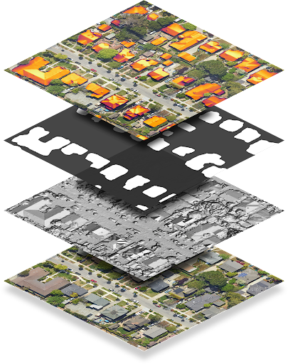
به استثنای لایه RGB، فایلهای GeoTIFF به درستی با نمایشگر تصویر نمایش داده نمیشوند، زیرا محتوا به جای تصاویر RGB، دادههای کدگذاری شده است. فایلهای GeoTIFF نیز نمیتوانند مستقیماً بهعنوان تصویر همپوشانی با Maps Javascript API استفاده شوند.
جدول زیر هر لایه را با جزئیات توضیح می دهد.
لایه
عمق پیکسل
قطعنامه
توضیحات
مدل سطح دیجیتال (DSM)
شناور 32 بیتی
0.1 متر بر پیکسل
داده های ارتفاعی که نشان دهنده توپوگرافی سطح زمین، از جمله ویژگی های طبیعی و ساخته شده است. مقادیر بر حسب متر بالاتر از سطح دریا می باشد. مکانهای نامعتبر یا مناطقی که دادهای نداریم، بهعنوان -9999 ذخیره میشوند.
RGB
8 بیتی
0.1 متر بر پیکسل 0.25 متر بر پیکسل 0.5 متر بر پیکسل 1 متر بر پیکسل
تصویر هوایی از منطقه فایل تصویری GeoTIFF شامل سه باند مربوط به مقادیر قرمز، سبز و آبی است تا مقدار RGB 24 بیتی را برای هر پیکسل تشکیل دهد.
به طور پیش فرض، وضوح پیکسل 0.1 متر بر پیکسل است.
ماسک ساختمانی
1 بیتی
0.1 متر بر پیکسل
یک بیت در هر پیکسل نشان می دهد که آیا آن پیکسل به عنوان بخشی از پشت بام در نظر گرفته می شود.
شار سالانه
شناور 32 بیتی
0.1 متر بر پیکسل
نقشه شار سالانه یا نور سالانه خورشید بر روی پشت بامهای منطقه. مقادیر kWh/kW/year هستند.
Flux برای هر مکان محاسبه می شود، نه فقط برای ساخت پشت بام ها. مکانهای نامعتبر، یا مناطقی که نتوانستیم شار را محاسبه کنیم، بهعنوان -9999 ذخیره میشوند. مکانهای خارج از منطقه تحت پوشش ما نامعتبر هستند.
توجه: این شار بدون نقاب است.
شار ماهانه
شناور 32 بیتی
0.5 متر بر پیکسل
نقشه شار ماهانه (نور خورشید روی پشت بام ها به تفکیک ماه) منطقه. مقادیر kWh/kW/year هستند. فایل تصویری GeoTIFF به ترتیب شامل 12 باند مربوط به ژانویه تا دسامبر است.
سایه ساعتی
عدد صحیح 32 بیتی
1 متر بر پیکسل
12 URL برای نقشه های سایه ساعتی مربوط به ژانویه تا دسامبر، به ترتیب.
هر فایل GeoTIFF شامل 24 باند، مربوط به 24 ساعت روز است. هر پیکسل یک عدد صحیح 32 بیتی است که مربوط به (تا) 31 روز آن ماه است. بیت 1 به این معنی است که مکان مربوطه می تواند خورشید را در آن روز، در آن ساعت، در آن ماه ببیند.
مکانهای نامعتبر بهعنوان -9999 ذخیره میشوند و دارای بیت 31 هستند، زیرا مربوط به روز 32 ماه است و بنابراین نامعتبر است.
رسترهای سایه ساعتی را رمزگشایی کنید
داده های سایه ساعتی در شطرنجی های چند باندی کدگذاری می شوند. برای کسب اطلاعات بیشتر در مورد اصول شطرنجی، به مفاهیم API خورشیدی مراجعه کنید.
هنگامی که درخواستی برای دادههای سایه ساعتی ارائه میکنید، میتوانید حداکثر 12 شطرنجی، یکی برای هر ماه از سال تقویم (ژانویه تا دسامبر) دریافت کنید. هر شطرنجی از 24 لایه یا نوار تشکیل شده است که مربوط به 24 ساعت روز است.
هر باند با ماتریسی از سلول ها یا پیکسل ها نشان داده می شود. هر پیکسل دارای عمق 32 بیت است که مربوط به (حداکثر) 31 روز ماه است. بنابراین رمزگشایی روز، زمان و ماه داده های سایه نیازمند درک بیت، باند و شطرنجی است که شما در حال تجزیه و تحلیل هستید.
به عنوان مثال، برای تشخیص اینکه آیا یک مکان مشخص در مختصات (x، y) خورشید را در ساعت 4:00 بعد از ظهر روز 22 ژوئن دیده است یا خیر، موارد زیر را انجام دهید:
یک درخواست لایه داده برای همه لایه ها برای مکان (x, y) ایجاد کنید.
از آنجایی که ماه ژوئن ششمین ماه سال است، ششمین URL را در لیست hourlyShadeUrls واکشی کنید.
باندهای ساعتی در 24 ساعت ارائه می شود. برای دریافت اطلاعات ساعت 16:00 (16:00)، کانال هفدهم را جستجو کنید.
شاخص بیت (روز) از 0. برای دریافت اطلاعات روز 22 ژوئن، بیت 21 را بخوانید.
بیت ها داده های دودویی را ارائه می دهند که نشان می دهد آیا آن مکان خورشید را در تاریخ و زمان معین دیده است یا خیر. اگر بیت 1 باشد، مکان خورشید را دید. اگر بیت 0 باشد، محل سایه را دید.
تاریخ آخرین بهروزرسانی 2025-08-27 بهوقت ساعت هماهنگ جهانی.
[null,null,["تاریخ آخرین بهروزرسانی 2025-08-27 بهوقت ساعت هماهنگ جهانی."],[[["\u003cp\u003eThe dataLayers endpoint provides access to various geographical data layers like elevation, aerial imagery, and solar potential, encoded in GeoTIFF format for use in GIS applications.\u003c/p\u003e\n"],["\u003cp\u003eGeoTIFF URLs are valid for one hour and the downloaded files can be stored for up to 30 days, with most layers requiring specialized software for proper visualization due to data encoding.\u003c/p\u003e\n"],["\u003cp\u003eThe hourly shade layer is encoded to indicate sun exposure for each location at a specific time and day of the month, requiring bitwise operations to decode the information.\u003c/p\u003e\n"],["\u003cp\u003eThe hourly shade data uses the location's regional time zone, assumes no leap days or daylight savings, and treats all days as 24 hours long with standard time noon.\u003c/p\u003e\n"]]],["The `dataLayers` endpoint provides GeoTIFF files for solar system design, accessible via URLs valid for one hour, and storable for 30 days. These files include: Digital Surface Model (DSM) for elevation; RGB imagery; Building mask indicating rooftop pixels; Annual flux showing annual sunlight; Monthly flux with sunlight data per month and hourly shade containing 12 rasters, with 24 layers for each hour of the day each month, each one represented by bits indicating whether the location saw the sun on a given day, hour and month.\n"],null,["# About GeoTIFF files\n\n**European Economic Area (EEA) developers** If your billing address is in the European Economic Area, effective on 8 July 2025, the [Google\n| Maps Platform EEA Terms of Service](https://cloud.google.com/terms/maps-platform/eea) will apply to your use of the Services. [Learn more](/maps/comms/eea/faq). In addition, certain content from the Solar API will no longer be returned. [Learn more](/maps/comms/eea/solar).\n\nThe [dataLayers](/maps/documentation/solar/data-layers) endpoint\nreturns data encoded as GeoTIFF files, which can be used in any geographic\ninformation system (GIS) application to design solar systems.\n\nEach string in the dataLayers response contains a URL, which you can\nuse to fetch the corresponding GeoTIFF. URLs are valid for up to an hour after\nthey are generated from the original data layers request. GeoTIFF files can be\nstored for up to 30 days.\n\nWith the exception of the RGB layer, GeoTIFF files don't display correctly with\nan image viewer, as the content is encoded data rather than RGB images. GeoTIFF\nfiles also cannot be used directly as an overlay image with Maps Javascript API.\n\nThe following table describes each layer in detail.\n\n| Layer | Pixel depth | Resolution | Description |\n|-----------------------------|----------------|------------------------------------------------|---------------------------------------------------------------------------------------------------------------------------------------------------------------------------------------------------------------------------------------------------------------------------------------------------------------------------------------------------------------------------------------------------------------------------------------------------------------------------------------------------------------|\n| Digital Surface Model (DSM) | 32-bit float | 0.1 m/pixel | Elevation data that represents the topography of Earth's surface, including natural and built features. Values are in meters above sea level. Invalid locations, or areas where we don't have data, are stored as -9999. |\n| RGB | 8-bit | 0.1 m/pixel 0.25 m/pixel 0.5 m/pixel 1 m/pixel | An aerial image of the region. The GeoTIFF imagery file contains three bands corresponding to red, green and blue values in order to form 24-bit RGB value for each pixel. By default, the pixel resolution is 0.1 m/pixel. |\n| Building mask | 1-bit | 0.1 m/pixel | One bit per pixel indicating whether that pixel is considered to be part of a rooftop. |\n| Annual flux | 32-bit float | 0.1 m/pixel | The annual flux map, or annual sunlight on roofs, of the region. Values are kWh/kW/year. Flux is computed for every location, not just building rooftops. Invalid locations, or areas where we couldn't calculate flux, are stored as -9999. Locations outside our [coverage area](/maps/documentation/solar/coverage) are invalid. **Note:** This is unmasked flux. |\n| Monthly flux | 32-bit float | 0.5 m/pixel | The monthly flux map (sunlight on roofs, broken down by month) of the region. Values are kWh/kW/year. The GeoTIFF imagery file contains 12 bands corresponding to January --- December, in order. |\n| Hourly shade | 32-bit integer | 1 m/pixel | 12 URLs for hourly shade maps corresponding to January --- December, in order. Each GeoTIFF file contains 24 bands, corresponding to the 24 hours of the day. Each pixel is a 32 bit integer, corresponding to the (up to) 31 days of that month. A 1 bit means that the corresponding location is able to see the sun on that day, at that hour, in that month. \u003cbr /\u003e Invalid locations are stored as -9999 and have bit 31 set, as that corresponds to the 32nd day of the month and is therefore invalid. |\n\nDecode hourly shade rasters\n---------------------------\n\nHourly shade data is encoded in multiband rasters. To learn more about raster\nbasics, see [Solar API Concepts](/maps/documentation/solar/concepts).\n\nWhen you make a request for hourly shade data, you can receive up to 12 rasters,\none for each month of the calendar year (January through December). Each raster\nis composed of 24 layers, or *bands*, which correspond to the 24 hours of the\nday.\n\nEach band is represented by a matrix of cells, or *pixels*. Each pixel has a\ndepth of 32 bits, which correspond to the (maximum) 31 days of the month.\nDecoding the day, time, and month of shade data, therefore, requires\nunderstanding the bit, band, and raster that you are analyzing.\n\nFor example, to identify whether a given location at coordinates (x, y) saw the\nsun at 4:00 PM on June 22, do the following:\n\n1. Make a data layers request for all layers for location (x, y).\n2. Because the month of June is the sixth month of the year, fetch the sixth URL in the `hourlyShadeUrls` list.\n3. Hourly bands are given in 24-hour time. To get data for 4:00 PM (16:00), look up the 17th channel.\n4. Bits (days) index from 0. To get data for the 22nd day of June, read bit 21.\n5. Bits provide binary data indicating whether that location saw sun at the given date and time. If the bit is 1, the location saw sun. If the bit is 0, the location saw shade.\n\nThe following code summarizes the steps above: \n\n```transact-sql\n(hourly_shade[month - 1])(x, y)[hour] & (1 \u003c\u003c (day - 1))\n```\n| **Note:** Hourly shade data is based on the regional time zone of the requested location. Hourly shade data also assumes that there are no leap days and that Daylight Savings Time does not exist. All days are assumed to be 24 hours long and noon is always \"standard time\" noon (12:00)."]]