- Disponibilidad del conjunto de datos
- 2009-01-01T00:00:00Z–2024-01-01T00:00:00Z
- Proveedor del conjunto de datos
- Agriculture and Agri-Food Canada
- Cadencia
- 1 año
- Etiquetas
Descripción
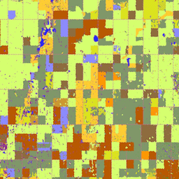
En 2009, el equipo de observación de la Tierra de la Subdivisión de Ciencia y Tecnología (STB) de Agriculture and Agri-Food Canada (AAFC) comenzó el proceso de generación de mapas digitales anuales de tipos de cultivos. En 2009 y 2010, se aplicó una metodología basada en árboles de decisión (DT) con imágenes satelitales ópticas (Landsat-5, AWiFS, DMC) y de radar (Radarsat-2) para centrarse en las provincias de las praderas. A partir de la temporada de cultivo del 2011, esta actividad se extendió a otras provincias para respaldar un inventario nacional de cultivos. Hasta la fecha, este enfoque puede proporcionar de forma constante un inventario de cultivos que cumple con el objetivo general de precisión de al menos el 85% con una resolución espacial final de 30 m (56 m en 2009 y 2010).
Bandas
Bandas
Tamaño de píxel: 30 metros (todas las bandas)
| Nombre | Mín. | Máx. | Tamaño de los píxeles | Descripción |
|---|---|---|---|---|
landcover |
10 | 230 | 30 metros | Clasificación principal de la cobertura terrestre específica del cultivo. |
Tabla de clases de cobertura del suelo
| Valor | Color | Descripción |
|---|---|---|
| 10 | #000000 | Cloud |
| 20 | #3333ff | Agua |
| 30 | #996666 | Tierra expuesta y estéril |
| 34 | #cc6699 | Urbano y desarrollado |
| 35 | #e1e1e1 | Invernaderos |
| 50 | #ffff00 | Shrubland |
| 60 | #666666 | Incendio forestal y área quemada |
| 80 | #993399 | Pantano |
| 85 | #501b50 | Turberas |
| 110 | #cccc00 | Pradera |
| 120 | #cc6600 | Agricultura (sin diferenciar) |
| 121 | #ff9933 | Tierras de cultivo |
| 122 | #ffcc33 | Pastos y forrajes |
| 130 | #7899f6 | Demasiado húmedo para sembrar |
| 131 | #ff9900 | Barbecho |
| 132 | #660000 | Cereales |
| 133 | #dae31d | Barley |
| 134 | #99cc00 | Otros granos |
| 135 | #d2db25 | Mijo |
| 136 | #d1d52b | Avena |
| 137 | #cacd32 | Centeno |
| 138 | #c3c63a | Spelt |
| 139 | #b9bc44 | Triticale |
| 140 | #a7b34d | Trigo |
| 141 | #b9c64e | Switchgrass |
| 142 | #999900 | Sorgo |
| 143 | #e9e2b1 | Quinoa |
| 145 | #809769 | Trigo de invierno |
| 146 | #92a55b | Trigo de primavera |
| 147 | #ffff99 | Maíz para grano |
| 148 | #98887c | Tabaco |
| 149 | #799b93 | Ginseng |
| 150 | #5ea263 | Semillas oleaginosas |
| 151 | #52ae77 | Borraja |
| 152 | #41bf7a | Camelina |
| 153 | #d6ff70 | Colza y canola |
| 154 | #8c8cff | Linaza |
| 155 | #d6cc00 | Mustard |
| 156 | #ff7f00 | Cártamo |
| 157 | #315491 | Un girasol |
| 158 | #cc9933 | Soja |
| 159 | #5ea296 | Otras semillas oleaginosas |
| 160 | #896e43 | Pulsos |
| 161 | #996633 | Otros pulsos |
| 162 | #8f6c3d | Guisantes |
| 163 | #b6a472 | Garbanzos |
| 167 | #82654a | Frijoles |
| 168 | #a39069 | Habas |
| 174 | #b85900 | Lentejas |
| 175 | #b74b15 | Unos vegetales |
| 176 | #ff8a8a | Tomates |
| 177 | #ffcccc | Papas |
| 178 | #6f55ca | Remolacha azucarera |
| 179 | #ffccff | Otros vegetales |
| 180 | #dc5424 | Frutas |
| 181 | #d05a30 | Bayas |
| 182 | #d20000 | Arándano |
| 183 | #cc0000 | Cranberry |
| 185 | #dc3200 | Otras bayas |
| 188 | #ff6666 | Huertos |
| 189 | #c5453b | Otras frutas |
| 190 | #7442bd | Viñedos |
| 191 | #ffcc99 | Lúpulo |
| 192 | #b5fb05 | Césped |
| 193 | #ccff05 | Hierbas |
| 194 | #07f98c | Guardería |
| 195 | #00ffcc | Alforfón |
| 196 | #cc33cc | Alpiste |
| 197 | #8e7672 | Cáñamo |
| 198 | #b1954f | Arveja |
| 199 | #749a66 | Otros cultivos |
| 200 | #009900 | Bosque (sin diferenciar) |
| 210 | #006600 | Coníferas |
| 220 | #00cc00 | Broadleaf |
| 230 | #cc9900 | Mixedwood |
Propiedades de imágenes
Propiedades de la imagen
| Nombre | Tipo | Descripción |
|---|---|---|
| landcover_class_names | STRING_LIST | Es un array de nombres de clasificación de la cobertura de la tierra de las tierras de cultivo. |
| landcover_class_palette | STRING_LIST | Es un array de cadenas de color en código hexadecimal que se usa para la paleta de clasificación. |
| landcover_class_values | INT_LIST | Valor de la clasificación de la cobertura del suelo. |
Condiciones de Uso
Condiciones de Uso
Citas
Inventario anual de cultivos de Agriculture and Agri-Food Canada. {YEAR}
Explora con Earth Engine
Editor de código (JavaScript)
var dataset = ee.ImageCollection('AAFC/ACI');
var crop2016 = dataset
    .filter(ee.Filter.date('2016-01-01', '2016-12-31'))
    .first();
Map.setCenter(-103.8881, 53.0372, 10);
Map.addLayer(crop2016, {}, '2016 Canada AAFC Annual Crop Inventory');
import ee
import geemap.core as geemap
Colab (Python)
dataset = ee.ImageCollection('AAFC/ACI')
crop_2016 = dataset.filter(ee.Filter.date('2016-01-01', '2016-12-31')).first()

m = geemap.Map()
m.set_center(-103.8881, 53.0372, 10)
m.add_layer(crop_2016, {}, '2016 Canada AAFC Annual Crop Inventory')
m