- 数据集可用时间
- 2018-01-01T00:00:00Z–2021-01-01T00:00:00Z
- 数据集生产者
- 艾伦珊瑚礁地图集合作伙伴关系 (ACA) 昆士兰大学 (UQ) 亚利桑那州立大学全球探索与保护科学中心 (ASU GDCS) 美国国家地理学会 (NGS) Vulcan Inc. (Vulcan)
- 标签
说明
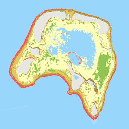
艾伦珊瑚礁地图集数据集以 5 米的像素分辨率绘制了全球浅水珊瑚礁的地貌带状分布和底栖生物栖息地。基础卫星图像数据是 2018 年至 2020 年间 PlanetScope 卫星图像的时间合成。栖息地地图是通过一种采用情境编辑的机器学习方法创建的,该方法使用一系列图像、水深测量数据和派生产品作为输入数据,并通过全球一致的参考数据集进行训练。此外,还包含一个全局遮罩层,用于生成全局报告统计信息。如需详细了解相关方法和途径,请参阅 Allen Coral Atlas 网站的方法部分。
艾伦珊瑚礁地图集由 Vulcan Inc. 资助,并由 Arizona State University Center for Global Discovery and Conservation Science 管理。合作伙伴包括 Planet、昆士兰大学和美国国家地理学会。
科学背景出版物:
Lyons, M. B., Roelfsema, C. M. Kennedy, E. V. Kovacs, E. M. Borrego-Acevedo, R.、Markey, K.、... & Murray, N. J. (2020 年)。利用全球多尺度地球观测框架绘制世界珊瑚礁地图。Remote Sensing in Ecology and Conservation,6(4),557-568。doi:10.1002/rse2.157
Kennedy, E. V. Roelfsema, C. M. Lyons, M. B., Kovacs, E. M. Borrego-Acevedo, R.、Roe, M.、... & Tudman, P. (2021 年)。Reef Cover,一种用于通过遥感技术绘制全球栖息地地图的珊瑚礁分类。Scientific Data, 8(1), 1-20. doi:10.1038/s41597-021-00958-z
Roelfsema, C. M. Lyons, M.、Murray, N.、Kovacs, E. M. Kennedy, E.、Markey, K.、... & Phinn, S. R. (2021 年)。生成专家派生的训练和验证数据的工作流程:全球范围的栖息地地图绘制视图。Frontiers in Marine Science。doi:10.3389/fmars.2021.643381
Li, J.、Knapp, D. E., Lyons, M.、Roelfsema, C.、Phinn, S.、Schill, S. R., & Asner, G. P. (2021 年)。使用 Google Earth Engine 自动绘制全球浅水水深图。Remote Sensing, 13(8), 1469. doi:10.3390/rs13081469
Li, J.、Knapp, D. E., Fabina, N. S., Kennedy, E. V. Larsen, K.,Lyons, M. B., ... & Asner, G. P. (2020 年)。使用卷积神经网络生成的全球珊瑚礁概率地图。Coral Reefs, 39(6), 1805-1815. doi:10.1007/s00338-020-02005-6
Allen Coral Atlas 地图、测深数据和地图统计信息版权归 Allen Coral Atlas Partnership 和 Vulcan, Inc. 所有,© 2020 年。
频段
波段
像素大小:5 米(所有波段)
| 名称 | 像元大小 | 说明 |
|---|---|---|
geomorphic |
5 米 | 地貌带划分。 |
benthic |
5 米 | 主要底栖生物组成的分类。 |
reef_mask |
5 米 | 使用全球珊瑚礁分类和测深产品组合而成的全球标准化珊瑚礁掩码。其预期用途是作为一种掩码(而非地图),用于标准化全球地貌/海底地形图的全球报告。 |
地貌类别表
| 值 | 颜色 | 说明 |
|---|---|---|
| 0 | #000000 | 未映射 |
| 11 | #77d0fc | 浅潟湖 - 浅潟湖是指任何封闭或半封闭、受庇护、平底的浅水沉积物为主的潟湖区域。 |
| 12 | #2ca2f9 | 深泻湖 - 深泻湖是指被珊瑚礁半封闭或完全封闭的任何受庇护的广阔水体,其深度不一(但比周围海洋浅),底部柔软,主要由珊瑚礁衍生的沉积物构成。 |
| 13 | #c5a7cb | 内礁坪 - 内礁坪是外礁坪后方一个低能、以沉积物为主的水平或缓倾斜平台。 |
| 14 | #92739d | 外礁坪 - 外礁坪与礁石向海一侧的边缘相邻,是一个水平(近乎水平)、宽阔而浅的平台,显示出强烈的波浪驱动型带状分布 |
| 15 | #614272 | 礁脊 - 礁脊是标志着礁坪和礁坡之间边界的区域,通常较浅,以最高的波浪能量吸收为特征。 |
| 16 | #fbdefb | 陆地礁坪 - 陆地礁坪是裙礁中宽阔、平坦、浅水到半暴露的区域,一侧直接附着在陆地上,容易受到淡水径流、营养物质和沉积物的影响。 |
| 21 | #10bda6 | 受庇护的礁坡 - 受庇护的礁坡是指任何延伸到深水区但受到陆地或相对的礁结构保护而免受强劲定向盛行风或水流影响的淹没倾斜区域。 |
| 22 | #288471 | 礁坡 - 礁坡是指从礁脊(或礁坪)向海延伸至陆架断裂处的倾斜水下区域。迎风面,如果没有主要盛行风或水流,则为任意方向。 |
| 23 | #cd6812 | 高原 - 高原是指任何较深的水下硬底水平或缓坡向海的礁特征。 |
| 24 | #befbff | 后礁坡 - 后礁坡是位于礁坪后面的一个复杂的内部礁区,通常坡度较缓。深度不一(但比礁坪深,坡度更大),受庇护,以沉积物为主,通常有珊瑚露头。 |
| 25 | #ffba15 | 块状礁 - 块状礁是指从沙底区域升起的任何小型、分离或半分离的泻湖珊瑚露头。 |
底栖生物类别表
| 值 | 颜色 | 说明 |
|---|---|---|
| 0 | #000000 | 未映射 |
| 11 | #ffffbe | 沙地 - 沙地是指以细小松散沉积物为主的任何软底区域。 |
| 12 | #e0d05e | 碎石 - 碎石是指任何以松散、粗糙的破碎珊瑚礁材料为特征的栖息地。 |
| 13 | #b19c3a | 岩石 - 岩石是指任何裸露的坚硬基质区域。 |
| 14 | #668438 | 海草 - 海草是指以海草为主要生物群的任何栖息地。 |
| 15 | #ff6161 | 珊瑚/藻类 - 珊瑚/藻类是指任何支持活珊瑚和/或藻类的硬底区域。 |
| 18 | #9bcc4f | 微藻垫 - 微藻垫是指沙质沉积物中任何可见的微观藻类聚集物。 |
reef_mask 类别表
| 值 | 颜色 | 说明 |
|---|---|---|
| 0 | #000000 | 非珊瑚礁 |
| 1 | #ffffff | 暗礁 |
使用条款
使用条款
引用
Allen Coral Atlas(2020 年)。全球热带珊瑚礁的图像、地图和监测数据。Zenodo. doi:10.5281/zenodo.3833242
DOI
通过 Earth Engine 探索
代码编辑器 (JavaScript)
var dataset = ee.Image('ACA/reef_habitat/v1_0');

// Teti'aroa, an atoll in French Polynesia.
Map.setCenter(-149.56194, -17.00872, 13);
Map.setOptions('SATELLITE');

// The visualizations are baked into the image properties.

// Example mask application.
var reefExtent = dataset.select('reef_mask').selfMask();
Map.addLayer(reefExtent, {}, 'Global reef extent');

// Geomorphic zonation classification.
var geomorphicZonation = dataset.select('geomorphic').selfMask();
Map.addLayer(geomorphicZonation, {}, 'Geomorphic zonation');

// Benthic habitat classification.
var benthicHabitat = dataset.select('benthic').selfMask();
Map.addLayer(benthicHabitat, {}, 'Benthic habitat');