- Доступность набора данных
- 2012-01-01T00:00:00Z–2012-01-01T00:00:00Z
- Производитель наборов данных
- АН
- Теги
Описание
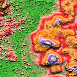
Цифровая модель рельефа AHN (DEM) — это модель рельефа с разрешением 0,5 м, охватывающая территорию Нидерландов. Она была создана на основе данных LIDAR, полученных весной 2007-2012 годов.
Он содержит образцы на уровне земли, из которых удалены все остальные объекты над землей (такие как здания, мосты, деревья и т. д.). Эта версия интерполирована; области, где были удалены объекты, заполнены интерполированными значениями. Облако точек было преобразовано в сетку с шагом 0,5 м с использованием метода взвешивания по квадрату обратного расстояния.
Группы
Группы
Размер пикселя: 0,5 метра (для всех диапазонов)
| Имя | Единицы | Размер пикселя | Описание |
|---|---|---|---|
elevation | м | 0,5 метра | Высота |
Условия эксплуатации
Условия эксплуатации
Наборы данных AHN доступны в качестве открытых данных. Это означает, что данные могут использоваться кем угодно бесплатно и без ограничений. Для получения дополнительной информации посетите страницу открытых данных . Загрузка данных осуществляется в соответствии с условиями лицензии CC-0 .
Исследуйте мир с помощью Earth Engine.
Редактор кода (JavaScript)
var dataset = ee.Image('AHN/AHN2_05M_INT');
var elevation = dataset.select('elevation');
var elevationVis = {
  min: -5.0,
  max: 30.0,
};
Map.setCenter(5.76583, 51.855276, 16);
Map.addLayer(elevation, elevationVis, 'Elevation');
import ee
import geemap.core as geemap
Colab (Python)
dataset = ee.Image('AHN/AHN2_05M_INT')
elevation = dataset.select('elevation')
elevation_vis = {'min': -5.0, 'max': 30.0}

m = geemap.Map()
m.set_center(5.76583, 51.855276, 16)
m.add_layer(elevation, elevation_vis, 'Elevation')
m