- Доступность набора данных
- 2020-01-01T00:00:00Z–2022-01-01T00:00:00Z
- Производитель наборов данных
- АН
- Теги
Описание
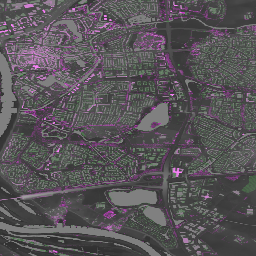
Actueel Hoogtebestand Nederland (AHN) — это набор данных с подробными и точными данными о высоте местности на всей территории Нидерландов. Информация о высоте была собрана с вертолетов и самолетов с использованием лазерной технологии с вертикальной точностью 5 см.
Набор данных AHN4 содержит переменные AHN 0,5m DSM и DTM для Нидерландов. Данные охватывают период с 2020 по 2022 год.
Цифровая модель рельефа (ЦМР) отображает высоту местности, а цифровая модель поверхности (ЦМП) — высоту самых высоких участков местности в данной точке.
Группы
Группы
Размер пикселя: 0,5 метра (для всех диапазонов)
| Имя | Единицы | Размер пикселя | Описание |
|---|---|---|---|
dtm | м | 0,5 метра | Высота над уровнем земли |
dsm | м | 0,5 метра | Высота самых высоких поверхностей в этой точке |
Условия эксплуатации
Условия эксплуатации
Наборы данных AHN доступны в качестве открытых данных. Это означает, что данные могут использоваться кем угодно бесплатно и без ограничений. Для получения дополнительной информации посетите страницу открытых данных . Загрузка данных осуществляется в соответствии с условиями лицензии CC-0 .
Исследуйте мир с помощью Earth Engine.
Редактор кода (JavaScript)
var dataset = ee.ImageCollection('AHN/AHN4');
var elevation = dataset.select('dsm');
var elevationVis = {
  min: -5.0,
  max: 30.0,
};
Map.setCenter(5.76583, 51.855276, 16);
Map.addLayer(elevation, elevationVis, 'AHN4 dsm');