- Disponibilidad del conjunto de datos
- 2019-01-01T00:00:00Z–2019-12-31T00:00:00Z
- Proveedor de conjuntos de datos
- Programa Biopama
- Etiquetas
Descripción
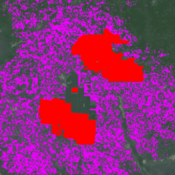
El conjunto de datos es un mapa global de 10 m de plantaciones industriales y de pequeña escala de palma de aceite para el año 2019. Abarca las áreas en las que se detectaron plantaciones de palma de aceite. Las imágenes clasificadas son el resultado de una red neuronal convolucional basada en composiciones semestrales de Sentinel-1 y Sentinel-2.
Consulta este artículo para obtener más información.
Bandas
Bandas
| Nombre | Tamaño de los píxeles | Descripción |
|---|---|---|
classification |
10 metros | Descripción de la clase de palma de aceite |
Tabla de clases de clasificación
| Valor | Color | Descripción |
|---|---|---|
| 1 | #ff0000 | Plantaciones industriales de palma aceitera con dosel cerrado |
| 2 | #ef00ff | Plantaciones de palma de aceite de dosel cerrado de pequeños agricultores |
| 3 | #696969 | Otras coberturas o usos del suelo que no sean de palma de aceite de dosel cerrado. |
Condiciones de Uso
Condiciones de Uso
Citas
Adrià, D., Serge, W., Erik, M., David, G., Stephen, P., y Zoltan, S. (2021). Mapa global de alta resolución de plantaciones industriales y pequeñas de palma aceitera para 2019 (versión v1) [Conjunto de datos]. Zenodo. doi:10.5281/zenodo.4473715
DOI
Explora con Earth Engine
Editor de código (JavaScript)
// Import the dataset; a collection of composite granules from 2019.
var dataset = ee.ImageCollection('BIOPAMA/GlobalOilPalm/v1');

// Select the classification band.
var opClass = dataset.select('classification');

// Mosaic all of the granules into a single image.
var mosaic = opClass.mosaic();

// Define visualization parameters.
var classificationVis = {
  min: 1,
  max: 3,
  palette: ['ff0000','ef00ff', '696969']
};

// Create a mask to add transparency to non-oil palm plantation class pixels.
var mask = mosaic.neq(3);
mask = mask.where(mask.eq(0), 0.6);

// Display the data on the map.
Map.addLayer(mosaic.updateMask(mask),
             classificationVis, 'Oil palm plantation type', true);
Map.setCenter(-3.0175, 5.2745,12);