- Dataset Availability
- 2020-01-01T00:00:00Z–2021-01-01T00:00:00Z
- Dataset Provider
- BNETD-CIGN
- Earth Engine Snippet
-
ee.ImageCollection("BNETD/land_cover/v1") - Tags
Description
The Cote d'Ivoire BNETD 2020 Land Cover Map was produced by the Ivorian Government through a national institution, the Center for Geographic Information and Digital from the National Study Office Techniques and Development (BNETD-CIGN), with technical and financial support from the European Union. The methodology used to produce the map was transparent, participatory and in line with international standards.
To develop this map, a mosaic of satellite images (Sentinel 2) from 2020 was processed via Google Earth Engine and supplemented with data collected in the field, to train a supervised classification algorithm (Random Forest). Two field campaigns were conducted, from 10 November to 9 December 2022 and from 26 January to 13 February 2023, throughout the country. These missions mobilized 33 people, census or inventory because the data collection methods, definitions used and purpose of the exercise are different.
As part of the EUDR due diligence process, geolocation data for plots of land producing EUDR-relevant products could be overlaid with 2020 forest cover data in order to assess the risk that the plot is located in an area that was forested before the 2020 cut-off date. To do this, forest cover data aligned with the FAO definition of forests and the 2020 cut-off date is required. The 2020 land cover map of Cote d'Ivoire meets these needs. Indeed, the classes in the land cover map can be combined to create a forest/non-forest map that is aligned with the FAO definition of forests.
A platform for accessing 2020 land cover data, metadata and the methodology has been developed using ESRI solutions, from Africa GeoPortal, for data analysis and visualization:
The address is: https://bit.ly/carte-ci-2020
Documentation:
Bands
Resolution
10 meters
Bands
| Name | Min | Max | Description |
|---|---|---|---|
classification |
1 | 23 | Land Cover class |
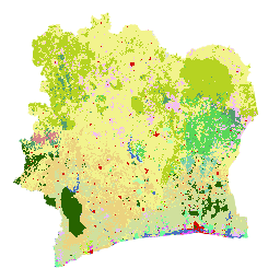
classification Class Table
| Value | Color | Description |
|---|---|---|
| 1 | #276300 | Dense forest (Forêt dense) |
| 2 | #59D757 | Light forest (Forêt claire) |
| 3 | #569D6E | Forest gallery (Forêt galerie) |
| 4 | #79CFAD | Secondary forest/degraded forest (Forêt secondaire/forêt dégradée) |
| 5 | #34734C | Mangrove |
| 6 | #B4FFAD | Forest plantation/Reforestation (Plantation forestière/Reboisement) |
| 7 | #6EFA9A | Swamp forest/Forest on hydromorphic soil (Forêt marécageuse/Forêt sur sol hydromorphe) |
| 8 | #D68589 | Coffee Plantation (Plantation de Café) |
| 9 | #EBD37F | Cocoa Plantation (Plantation de Cacao) |
| 10 | #D0E09D | Rubber plantation (Plantation d'Hévéa) |
| 11 | #E8BEFF | Oil palm plantation (Plantation de Palmier à huile) |
| 12 | #E751FE | Coconut Plantation (Plantation de Coco) |
| 13 | #F3BFF2 | Cashew plantation (Plantation d'Anacarde) |
| 14 | #9DFD00 | Fruit plantation / Arboriculture (Plantation fruitière / Arboricultures) |
| 15 | #F2F38D | Agricultural development/Other crops/Orchards/Fallow land (Aménagement agricole/Autres cultures/Vergers/Jachères) |
| 16 | #B6D322 | Tree savannah (Savane arborée) |
| 17 | #E2FE5F | Shrub formations/ Thickets (Formations arbustives/ Fourrés) |
| 18 | #F9FDCC | Herbaceous formations (Formations herbacées) |
| 19 | #4A70C0 | Body of water, Courses and waterways (Plan d'eau, Cours et voies deau) |
| 20 | #BEFFE8 | Swampy area (Zone marécageuse) |
| 21 | #D20A02 | Human habitat, Infrastructure (Habitat humain, Infrastructures) |
| 22 | #DBECEF | Rocky outcrop (Affleurement rocheux) |
| 23 | #DCDCDC | Bare ground (Sol nu) |
Terms of Use
Terms of Use
Citations
BNETD Land Cover Map 2020.
Explore with Earth Engine
Code Editor (JavaScript)
var dataset = ee.Image('BNETD/land_cover/v1/2020').select('classification');

Map.setCenter(-5.4400, 7.5500, 7);

Map.addLayer(dataset, {}, "Cote d'Ivoire Land Cover Map 2020");