- 資料集開放期間
- 2019-01-01T01:00:00Z–2020-01-01T01:00:00Z
- 資料集產生者
- National Forest Information System
- 標記
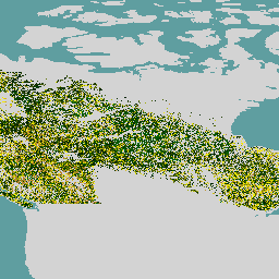
說明
加拿大原始森林資料集是 2019 年加拿大森林生態區的衛星森林年齡地圖,空間解析度為 30 公尺。系統會使用 Landsat (干擾、地表反射率合成、森林結構) 和 MODIS (總初級生產力) 的遙測資料,判斷樹齡。
如果可以直接識別干擾 (干擾法),或使用光譜資訊推斷 (復原法),或使用反向異速生長方程式模擬沒有干擾證據的年齡 (異速生長法),即可判斷森林年齡。干擾方法是以衛星資料和對應的變化為依據,因此最準確。此外,復原方法也採用衛星資料和森林演替相關邏輯,準確度高於純粹的建模。
由於加拿大森林近期未發生大規模擾動,因此最大面積 (86.6%) 必須採用異速生長法。如果無法以其他方式估算年齡,系統會使用實際高度、成長和產量模型等資訊估算年齡。系統會繪製所有樹木的年齡,並將樹齡超過 150 年的樹木歸入「老樹」類別。
頻帶
波段
像素大小:30 公尺 (所有頻帶)
| 名稱 | 單位 | 像素大小 | 說明 |
|---|---|---|---|
forest |
y | 30 公尺 | 森林年齡 |
使用條款
使用條款
本文所述的加拿大森林生態系統森林年齡地圖為開放原始碼,並由加拿大政府支援。資料集是依據 CC-BY 4.0 授權。
使用 Earth Engine 探索
程式碼編輯器 (JavaScript)
var dataset = ee.ImageCollection('CANADA/NFIS/NTEMS/CA_FOREST_AGE');

Map.setCenter(-107.94, 58.18, 3);
Map.addLayer(
    dataset,
    {palette: ['006600', '002200', 'fff700', 'ab7634', 'c4d0ff', 'ffffff']},
    'Canada Primary Forest Data');