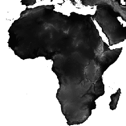
셔틀 레이더 지형 임무 (SRTM) 디지털 고도 데이터 세트는 원래 전 세계에 가까운 범위에서 일관되고 고품질의 고도 데이터를 제공하기 위해 제작되었습니다. 이 버전의 SRTM 디지털 고도 데이터는 데이터 공백을 채우고 사용 편의성을 높이기 위해 처리되었습니다.
대역
대역
이름
단위
최소
최대
픽셀 크기
설명
elevation
m
-444*
8806*
90미터
고도
* 예상 최솟값 또는 최댓값
이용약관
이용약관
배포 사용자는 CIAT의 명시적인 서면 허가 없이 상업적, 비무료 재판매 또는 재배포를 할 수 없습니다. 사용자는 이 데이터 세트의 사용으로 생성된 보고서, 간행물, 새 데이터 세트, 파생 제품 또는 서비스의 생성에 사용된 소스로 CIAT를 인정해야 합니다. CIAT는 또한 모든 간행물의 재인쇄와 재배포 노력에 대한 알림을 요청합니다. 데이터에 상업적으로 액세스하려면 Andy Jarvis에게 요청을 보내세요.
보증 또는 책임 없음 CIAT는 상품성 및 특정 목적에 대한 적합성 보증을 포함하되 이에 국한되지 않는 명시적 또는 묵시적 보증을 포함한 어떠한 종류의 보증도 없이 이 데이터를 제공합니다. CIAT는 데이터 사용으로 인해 발생하는 부수적, 결과적 또는 특별 손해에 대해 책임을 지지 않습니다.
감사 및 인용 이 데이터를 사용하는 게시된 자료에서 이 데이터를 인용하고 가능한 경우 웹페이지를 CIAT-CSI SRTM 웹사이트에 연결해 주시기 바랍니다.
인용
인용:
Jarvis, A., H.I. Reuter, A. Nelson, E. 게바라. 2008. CGIAR-CSI SRTM 90m 데이터베이스(https://srtm.csi.cgiar.org)에서 제공되는 전 세계의 홀 채워진 SRTM 버전 4
[null,null,[],[[["\u003cp\u003eCGIAR/SRTM90_V4 provides global elevation data collected during the Shuttle Radar Topography Mission (SRTM).\u003c/p\u003e\n"],["\u003cp\u003eThis version of the SRTM dataset has been processed to fill data voids for ease of use.\u003c/p\u003e\n"],["\u003cp\u003eThe dataset has a spatial resolution of 90 meters and includes a single band representing elevation in meters.\u003c/p\u003e\n"],["\u003cp\u003eUsers must acknowledge CIAT and adhere to non-commercial use restrictions; redistribution requires explicit permission.\u003c/p\u003e\n"],["\u003cp\u003eEarth Engine provides tools and resources for analyzing and visualizing the CGIAR/SRTM90_V4 dataset.\u003c/p\u003e\n"]]],["The CGIAR-CSI SRTM Version 4 dataset, available from February 11th to 22nd, 2000, provides near-global elevation data processed to fill voids. Users can access it via Earth Engine, using the `ee.Image(\"CGIAR/SRTM90_V4\")` snippet. Data, with 90-meter pixel resolution, ranges from -444 to 8806 meters. Usage requires acknowledging CIAT and is prohibited for commercial resale without permission. Users can create slope and elevation layers with the python or javascript api to be displayed on the map.\n"],null,["# SRTM Digital Elevation Data Version 4\n\nDataset Availability\n: 2000-02-11T00:00:00Z--2000-02-22T00:00:00Z\n\nDataset Provider\n:\n\n\n [NASA/CGIAR](https://srtm.csi.cgiar.org/)\n\nTags\n:\n [dem](/earth-engine/datasets/tags/dem) [elevation](/earth-engine/datasets/tags/elevation) [elevation-topography](/earth-engine/datasets/tags/elevation-topography) [geophysical](/earth-engine/datasets/tags/geophysical) [srtm](/earth-engine/datasets/tags/srtm) [topography](/earth-engine/datasets/tags/topography) \ncgiar \n\n#### Description\n\nThe Shuttle Radar Topography Mission (SRTM) digital\nelevation dataset was originally produced to provide consistent,\nhigh-quality elevation data at near global scope. This version\nof the SRTM digital elevation data has been processed to fill data\nvoids, and to facilitate its ease of use.\n\n### Bands\n\n**Bands**\n\n| Name | Units | Min | Max | Pixel Size | Description |\n|-------------|-------|--------|--------|------------|-------------|\n| `elevation` | m | -444\\* | 8806\\* | 90 meters | Elevation |\n\n\\* estimated min or max value\n\n### Terms of Use\n\n**Terms of Use**\n\nDISTRIBUTION. Users are prohibited from any commercial, non-free resale, or\nredistribution without explicit written permission from CIAT. Users should\nacknowledge CIAT as the source used in the creation of any reports,\npublications, new datasets, derived products, or services resulting from the\nuse of this dataset. CIAT also request reprints of any publications and\nnotification of any redistributing efforts. For commercial access to\nthe data, send requests to [Andy Jarvis](mailto:a.jarvis@cgiar.org).\n\nNO WARRANTY OR LIABILITY. CIAT provides these data without any warranty of\nany kind whatsoever, either express or implied, including warranties of\nmerchantability and fitness for a particular purpose. CIAT shall not be\nliable for incidental, consequential, or special damages arising out of\nthe use of any data.\n\nACKNOWLEDGMENT AND CITATION. Any users are kindly asked to cite this data\nin any published material produced using this data, and if possible link\nweb pages to the [CIAT-CSI SRTM website](https://srtm.csi.cgiar.org).\n\n### Citations\n\nCitations:\n\n- Jarvis, A., H.I. Reuter, A. Nelson, E. Guevara. 2008. Hole-filled\n SRTM for the globe Version 4, available from the CGIAR-CSI SRTM\n 90m Database: \u003chttps://srtm.csi.cgiar.org\u003e.\n\n### Explore with Earth Engine\n\n| **Important:** Earth Engine is a platform for petabyte-scale scientific analysis and visualization of geospatial datasets, both for public benefit and for business and government users. Earth Engine is free to use for research, education, and nonprofit use. To get started, please [register for Earth Engine access.](https://console.cloud.google.com/earth-engine)\n\n### Code Editor (JavaScript)\n\n```javascript\nvar dataset = ee.Image('CGIAR/SRTM90_V4');\nvar elevation = dataset.select('elevation');\nvar slope = ee.Terrain.slope(elevation);\nMap.setCenter(-112.8598, 36.2841, 10);\nMap.addLayer(slope, {min: 0, max: 60}, 'slope');\n```\nPython setup\n\nSee the [Python Environment](/earth-engine/guides/python_install) page for information on the Python API and using\n`geemap` for interactive development. \n\n```python\nimport ee\nimport geemap.core as geemap\n```\n\n### Colab (Python)\n\n```python\ndataset = ee.Image('CGIAR/SRTM90_V4')\nelevation = dataset.select('elevation')\nslope = ee.Terrain.slope(elevation)\n\nm = geemap.Map()\nm.set_center(-112.8598, 36.2841, 10)\nm.add_layer(slope, {'min': 0, 'max': 60}, 'slope')\nm\n```\n[Open in Code Editor](https://code.earthengine.google.com/?scriptPath=Examples:Datasets/CGIAR/CGIAR_SRTM90_V4) \n[SRTM Digital Elevation Data Version 4](/earth-engine/datasets/catalog/CGIAR_SRTM90_V4) \nThe Shuttle Radar Topography Mission (SRTM) digital elevation dataset was originally produced to provide consistent, high-quality elevation data at near global scope. This version of the SRTM digital elevation data has been processed to fill data voids, and to facilitate its ease of use. \nCGIAR/SRTM90_V4, dem,elevation,elevation-topography,geophysical,srtm,topography \n2000-02-11T00:00:00Z/2000-02-22T00:00:00Z \n-56 -180 60 180 \nGoogle Earth Engine \nhttps://developers.google.com/earth-engine/datasets\n\n- [](https://doi.org/https://srtm.csi.cgiar.org/)\n- [](https://doi.org/https://developers.google.com/earth-engine/datasets/catalog/CGIAR_SRTM90_V4)"]]