- Ketersediaan Set Data
- 2000-01-01T00:00:00Z–2020-01-01T00:00:00Z
- Produsen Set Data
- NASA SEDAC di Center for International Earth Science Information Network
- Rangkaian Langkah Penjualan
- 5 Tahun
- Tag
Deskripsi
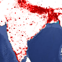
Set data ini berisi perkiraan jumlah orang per sel petak 30 detik busur yang konsisten dengan sensus nasional dan daftar populasi. Ada satu gambar untuk setiap tahun yang dimodelkan.
Gridded Population of World Version 4 (GPWv4), Revision 11 memodelkan distribusi populasi manusia global untuk tahun 2000, 2005, 2010, 2015, dan 2020 pada sel petak 30 detik busur (sekitar 1 km). Populasi didistribusikan ke sel menggunakan alokasi proporsional populasi dari sensus dan unit administratif. Data input populasi dikumpulkan pada resolusi spasial paling detail yang tersedia dari hasil sensus putaran 2010, yang dilakukan antara tahun 2005 dan 2014. Data input diekstrapolasi untuk menghasilkan estimasi populasi untuk setiap tahun yang dimodelkan.
Band
Band
Ukuran piksel: 927,67 meter (semua band)
| Nama | Min | Maks | Ukuran Piksel | Deskripsi |
|---|---|---|---|---|
population_count |
0* | 627597* | 927,67 meter | Perkiraan jumlah orang per sel petak 30 detik busur. |
Persyaratan Penggunaan
Persyaratan Penggunaan
Kutipan
Center for International Earth Science Information Network - CIESIN - Columbia University. 2018. Gridded Population of the World, Versi 4 (GPWv4): Jumlah Populasi, Revisi 11. Palisades, NY: NASA Socioeconomic Data and Applications Center (SEDAC). https://doi.org/10.7927/H4JW8BX5. Diakses pada HARI BULAN TAHUN.
DOI
Mengeksplorasi dengan Earth Engine
Editor Kode (JavaScript)
var dataset = ee.ImageCollection('CIESIN/GPWv411/GPW_Population_Count').first();
var raster = dataset.select('population_count');
var raster_vis = {
  'max': 1000.0,
  'palette': [
    'ffffe7',
    '86a192',
    '509791',
    '307296',
    '2c4484',
    '000066'
  ],
  'min': 0.0
};
Map.setCenter(79.1, 19.81, 3);
Map.addLayer(raster, raster_vis, 'population_count');