Этот набор данных содержит оценки числа жителей на ячейку сетки размером 30 угловых секунд, соответствующие данным национальных переписей и реестров населения. Для каждого моделируемого года представлено одно изображение.
Модель населения мира с координатной сеткой версии 4 (GPWv4), редакция 11, моделирует распределение населения мира за 2000, 2005, 2010, 2015 и 2020 годы в ячейках сетки с шагом 30 угловых секунд (приблизительно 1 км). Население распределяется по ячейкам пропорционально, исходя из данных переписи и административных единиц. Входные данные о населении собираются с максимально возможным пространственным разрешением, доступным по результатам раунда переписей 2010 года, проводившихся с 2005 по 2014 год. Входные данные экстраполируются для получения оценок численности населения для каждого моделируемого года.
Группы
Размер пикселя 927,67 метра
Группы
Имя
Мин.
Макс
Размер пикселя
Описание
population_count
0*
627597*
метров
Расчетное количество человек на 30-секундную ячейку сетки.
Центр международной информационной сети по наукам о Земле (CIESIN) — Колумбийский университет. 2018. Gridded Population of the World, версия 4 (GPWv4): Population Count, редакция 11. Палисейдс, штат Нью-Йорк: Центр социально-экономических данных и приложений НАСА (SEDAC). https://doi.org/10.7927/H4JW8BX5 . Дата обращения: ДЕНЬ МЕСЯЦ ГОД.
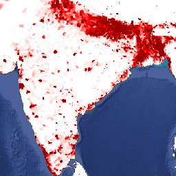
Этот набор данных содержит оценки количества жителей на ячейку сетки размером 30 угловых секунд, соответствующие данным национальных переписей населения и реестров населения. Для каждого моделируемого года представлено одно изображение. Примечание к общей документации: поскольку в этой коллекции используется пирамидальная политика MEAN, уменьшение масштаба приводит к потере информации. Для расчётов необходимо…
[null,null,[],[[["\u003cp\u003eThe Gridded Population of the World Version 4 (GPWv4), Revision 11 dataset provides estimates of the human population distributed across the globe on a 30 arc-second grid for the years 2000, 2005, 2010, 2015, and 2020.\u003c/p\u003e\n"],["\u003cp\u003ePopulation counts are modeled based on national censuses and population registers, using proportional allocation to distribute population within grid cells.\u003c/p\u003e\n"],["\u003cp\u003eThe dataset is available from NASA's Socioeconomic Data and Applications Center (SEDAC) and is accessible through Google Earth Engine.\u003c/p\u003e\n"],["\u003cp\u003eIt's important to note that zooming out on this dataset in Earth Engine can lead to information loss due to the dataset's pyramid policy of MEAN, so calculations should be done at native resolution.\u003c/p\u003e\n"],["\u003cp\u003eThe dataset is licensed under CC-BY-4.0 and requires attribution to CIESIN - Columbia University.\u003c/p\u003e\n"]]],["The dataset from NASA SEDAC, accessible via Earth Engine, provides gridded population data (GPWv4) from 2000 to 2020, updated every five years. It estimates the number of people per 30 arc-second grid cell (approximately 1km) using census and population registers. The `population_count` band represents the estimated number of persons per grid cell, with a pixel size of 927.67 meters. Data is distributed proportionally from census units, extrapolated for modeled years. The data should be calculated at its native resolution due to the data model.\n"],null,["# GPWv411: Population Count (Gridded Population of the World Version 4.11)\n\nDataset Availability\n: 2000-01-01T00:00:00Z--2020-01-01T00:00:00Z\n\nDataset Provider\n:\n\n\n [NASA SEDAC at the Center for International Earth Science Information Network](https://doi.org/10.7927/H4JW8BX5)\n\nCadence\n: 5 Years\n\nTags\n:\n[ciesin](/earth-engine/datasets/tags/ciesin) [gpw](/earth-engine/datasets/tags/gpw) [nasa](/earth-engine/datasets/tags/nasa) [population](/earth-engine/datasets/tags/population) \n\n#### Description\n\nThis dataset contains estimates of the number of persons per\n30 arc-second grid cell consistent with national censuses and population\nregisters. There is one image for each modeled year.\n\n[General Documentation](https://sedac.ciesin.columbia.edu/data/set/gpw-v4-population-count-rev11/docs)\n| **Note:** Because this collection has a pyramid policy of MEAN, zooming out results in information loss. Calculations need to be performed at native resolution.\n\nThe Gridded Population of World Version 4 (GPWv4), Revision 11 models the distribution\nof global human population for the years 2000, 2005, 2010, 2015, and 2020\non 30 arc-second (approximately 1 km) grid cells. Population is distributed\nto cells using proportional allocation of population from census and\nadministrative units. Population input data are collected at the most\ndetailed spatial resolution available from the results of the 2010 round of\ncensuses, which occurred between 2005 and 2014. The input data are\nextrapolated to produce population estimates for each modeled year.\n\n### Bands\n\n\n**Pixel Size**\n\n927.67 meters\n\n**Bands**\n\n| Name | Min | Max | Pixel Size | Description |\n|--------------------|-----|----------|------------|--------------------------------------------------------------|\n| `population_count` | 0\\* | 627597\\* | meters | The estimated number of persons per 30 arc-second grid cell. |\n\n\\* estimated min or max value\n\n### Terms of Use\n\n**Terms of Use**\n\n[CC-BY-4.0](https://spdx.org/licenses/CC-BY-4.0.html)\n\n### Citations\n\nCitations:\n\n- Center for International Earth Science Information Network - CIESIN -\n Columbia University. 2018. Gridded Population of the World, Version 4\n (GPWv4): Population Count, Revision 11. Palisades, NY: NASA Socioeconomic Data and\n Applications Center (SEDAC). \u003chttps://doi.org/10.7927/H4JW8BX5\u003e.\n Accessed DAY MONTH YEAR.\n\n### DOIs\n\n- \u003chttps://doi.org/10.7927/H4JW8BX5\u003e\n\n### Explore with Earth Engine\n\n| **Important:** Earth Engine is a platform for petabyte-scale scientific analysis and visualization of geospatial datasets, both for public benefit and for business and government users. Earth Engine is free to use for research, education, and nonprofit use. To get started, please [register for Earth Engine access.](https://console.cloud.google.com/earth-engine)\n\n### Code Editor (JavaScript)\n\n```javascript\nvar dataset = ee.ImageCollection('CIESIN/GPWv411/GPW_Population_Count').first();\nvar raster = dataset.select('population_count');\nvar raster_vis = {\n 'max': 1000.0,\n 'palette': [\n 'ffffe7',\n '86a192',\n '509791',\n '307296',\n '2c4484',\n '000066'\n ],\n 'min': 0.0\n};\nMap.setCenter(79.1, 19.81, 3);\nMap.addLayer(raster, raster_vis, 'population_count');\n```\n[Open in Code Editor](https://code.earthengine.google.com/?scriptPath=Examples:Datasets/CIESIN/CIESIN_GPWv411_GPW_Population_Count) \n[GPWv411: Population Count (Gridded Population of the World Version 4.11)](/earth-engine/datasets/catalog/CIESIN_GPWv411_GPW_Population_Count) \nThis dataset contains estimates of the number of persons per 30 arc-second grid cell consistent with national censuses and population registers. There is one image for each modeled year. General Documentation Note: Because this collection has a pyramid policy of MEAN, zooming out results in information loss. Calculations need to ... \nCIESIN/GPWv411/GPW_Population_Count, ciesin,gpw,nasa,population \n2000-01-01T00:00:00Z/2020-01-01T00:00:00Z \n-90 -180 90 180 \nGoogle Earth Engine \nhttps://developers.google.com/earth-engine/datasets\n\n- [https://doi.org/10.7927/H4JW8BX5](https://doi.org/https://doi.org/10.7927/H4JW8BX5)\n- [https://doi.org/10.7927/H4JW8BX5](https://doi.org/https://developers.google.com/earth-engine/datasets/catalog/CIESIN_GPWv411_GPW_Population_Count)"]]