- Доступность набора данных
- 2000-01-01T00:00:00Z–2020-01-01T00:00:00Z
- Поставщик наборов данных
- NASA SEDAC в Центре международной информационной сети наук о Земле
- Каденция
- 5 лет
- Теги
Описание
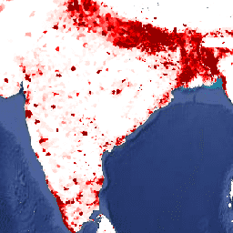
Этот набор данных содержит оценки численности населения в ячейке сетки размером 30 угловых секунд, соответствующие данным национальных переписей и реестров населения относительно относительного пространственного распределения, но скорректированные с учетом пересмотренных данных ООН о мировых демографических перспективах за 2015 год. Для каждого моделируемого года представлено одно изображение.
Модель населения мира с координатной сеткой версии 4 (GPWv4), редакция 11, моделирует распределение населения мира за 2000, 2005, 2010, 2015 и 2020 годы в ячейках сетки с шагом 30 угловых секунд (приблизительно 1 км). Население распределяется по ячейкам пропорционально переписи и административным единицам. Входные данные о населении собираются с максимально возможным пространственным разрешением, доступным по результатам раунда переписей 2010 года, проводившихся с 2005 по 2014 год. Входные данные экстраполируются для получения оценок численности населения для каждого моделируемого года.
Группы
Размер пикселя
927,67 метра
Группы
| Имя | Мин. | Макс | Размер пикселя | Описание |
|---|---|---|---|---|
unwpp-adjusted_population_count | 0* | 602380* | метров | Расчетное количество человек на 30-секундную ячейку сетки. |
Условия эксплуатации
Условия эксплуатации
Цитаты
Центр международной информационной сети наук о Земле (CIESIN) — Колумбийский университет. 2018. Население мира в координатной сетке, версия 4 (GPWv4): численность населения, скорректированная в соответствии с пересмотренными данными ООН по населению Земли за 2015 год, редакция 11. Палисейдс, штат Нью-Йорк: Центр социально-экономических данных и приложений НАСА (SEDAC). https://doi.org/10.7927/H4PN93PB . Дата обращения: ДЕНЬ МЕСЯЦ ГОД.
DOI
Исследуйте с Earth Engine
Редактор кода (JavaScript)
var dataset = ee.ImageCollection('CIESIN/GPWv411/GPW_UNWPP-Adjusted_Population_Count').first();
var raster = dataset.select('unwpp-adjusted_population_count');
var raster_vis = {
  'max': 1000.0,
  'palette': [
    'ffffe7',
    '86a192',
    '509791',
    '307296',
    '2c4484',
    '000066'
  ],
  'min': 0.0
};
Map.setCenter(79.1, 19.81, 3);
Map.addLayer(raster, raster_vis, 'unwpp-adjusted_population_count');