- זמינות מערך הנתונים
- 2000-01-01T00:00:00Z–2020-01-01T00:00:00Z
- ספק מערך נתונים
- NASA SEDAC at the Center for International Earth Science Information Network
- קצב
- 5 שנים
- תגים
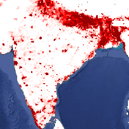
תיאור
קבוצת הנתונים הזו מכילה אומדנים של מספר האנשים בכל תא ברשת של 30 שניות קשת, בהתאם למפקדי אוכלוסין ולמרשמי אוכלוסין, מבחינת התפלגות מרחבית יחסית, אבל עם התאמה לנתונים הכוללים של המדינות בגרסה המעודכנת של תחזיות האוכלוסייה העולמית של האו"ם משנת 2015. יש תמונה אחת לכל שנה שמוצגת במודל.
המודלים של Gridded Population of World Version 4 (GPWv4), Revision 11 (אוכלוסייה מחולקת לרשתות, גרסה 4, תיקון 11) ממפים את פיזור האוכלוסייה האנושית בעולם בשנים 2000, 2005, 2010, 2015 ו-2020 בתאי רשת של 30 שניות קשת (כקילומטר אחד). האוכלוסייה מחולקת לתאים באמצעות הקצאה יחסית של אוכלוסייה מנתוני מפקד האוכלוסין ומיחידות אדמיניסטרטיביות. נתוני הקלט של האוכלוסייה נאספים ברזולוציה המרחבית המפורטת ביותר שזמינה מתוצאות סבב מפקדי האוכלוסין של 2010, שהתרחש בין 2005 ל-2014. נתוני הקלט מחושבים בשיטת האקסטרפולציה כדי להפיק אומדנים של האוכלוסייה לכל שנה שמוצגת במודל.
תחום תדרים
גודל פיקסל
927.67 מטרים
תחום תדרים
| שם | מינימום | מקסימום | גודל הפיקסל | תיאור |
|---|---|---|---|---|
unwpp-adjusted_population_density |
0* | 778120* | מטרים | המספר המשוער של אנשים לכל קילומטר רבוע. |
תנאים והגבלות
תנאים והגבלות
ציטוטים ביבליוגרפיים
המרכז הבינלאומי למידע על מדעי כדור הארץ – CIESIN – אוניברסיטת קולומביה. 2018. Gridded Population of the World, Version 4 (GPWv4.11): Population Density Adjusted to Match 2015 Revision of UN WPP Country Totals, Revision 11. Palisades, NY: NASA Socioeconomic Data and Applications Center (SEDAC). https://doi.org/10.7927/H4F47M65. תאריך הגישה: יום חודש שנה.
מספרי DOI
סיור באמצעות Earth Engine
עורך הקוד (JavaScript)
var dataset = ee.ImageCollection('CIESIN/GPWv411/GPW_UNWPP-Adjusted_Population_Density').first();
var raster = dataset.select('unwpp-adjusted_population_density');
var raster_vis = {
  'max': 1000.0,
  'palette': [
    'ffffe7',
    'FFc869',
    'ffac1d',
    'e17735',
    'f2552c',
    '9f0c21'
  ],
  'min': 0.0
};
Map.setCenter(79.1, 19.81, 3);
Map.addLayer(raster, raster_vis, 'unwpp-adjusted_population_density');