- Disponibilidade de conjuntos de dados
- 2010-07-01T00:00:00Z–2016-07-01T00:00:00Z
- Provedor de conjunto de dados
- CPOM
- Tags
Descrição
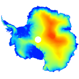
Esse conjunto de dados é um modelo digital de elevação (MDE) da camada de gelo e das plataformas de gelo da Antártica com base em observações registradas pelo altímetro de radar do satélite CryoSat-2 entre julho de 2010 e julho de 2016.
O DEM é formado por ajustes espaço-temporais às medições de elevação acumuladas em células de grade de 1, 2 e 5 km e é postado na resolução modal de 1 km. A diferença mediana e quadrática média entre o DEM e 2,3*107; as medições de altímetro a laser aerotransportado adquiridas durante as campanhas da Operação IceBridge da NASA são -0,30 e 13,50 m, respectivamente.
A incerteza do DEM aumenta em regiões de alta inclinação, especialmente onde as medições de elevação foram adquiridas no modo de baixa resolução.Levando isso em consideração, estimamos que a acurácia média seja de 9,5 m.
Bandas
Tamanho do pixel
1.000 metros
Bandas
| Nome | Unidades | Tamanho do pixel | Descrição |
|---|---|---|---|
elevation |
m | metros | Elevação da camada de gelo e da plataforma de gelo da Antártica. |
data_composition |
metros | Método de tratamento de dados de elevação por célula de grade. |
|
slope |
graus | metros | Inclinação derivada do gradiente de elevação. |
z_smoothed |
m | metros | Versão suavizada do modelo de elevação usando um filtro de mediana. |
z_uncertainty |
m | metros | Certeza do modelo de elevação derivada do RMS de resíduos de elevação em células de grade observadas e do erro de variância de krigagem em células de grade interpoladas. |
Tabela de classes data_composition
| Valor | Cor | Descrição |
|---|---|---|
| 0 | #000000 | interpolado |
| 1 | #cbcbcb | 1 km de treino |
| 2 | #377eb7 | ajuste de 2 km reamostrado |
| 3 | #e2191b | ajuste de 5 km reamostrado |
Termos de Uso
Termos de Uso
Citações
Slater, T., Shepherd, A., McMillan, M., Muir, A., Gilbert, L., Hogg, A. E., Konrad, H. e Parrinello, T.: Um novo modelo digital de elevação da Antártica derivado da altimetria do CryoSat-2, The Cryosphere, doi:10.5194/tc-2017-223, 2018
DOIs
Explorar com o Earth Engine
Editor de código (JavaScript)
var dataset = ee.Image('CPOM/CryoSat2/ANTARCTICA_DEM');

var visualization = {
  bands: ['elevation'],
  min: 0.0,
  max: 4000.0,
  palette: ['001fff', '00ffff', 'fbff00', 'ff0000']
};

Map.setCenter(17.0, -76.0, 3);

Map.addLayer(dataset, visualization, 'Elevation');