- ডেটাসেটের প্রাপ্যতা
- 2006-01-24T00:00:00Z–2011-05-13T00:00:00Z
- ডেটাসেট প্রযোজক
- সংরক্ষণ বিজ্ঞান অংশীদার
- ট্যাগ
বর্ণনা
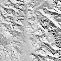
CHILI হলো বাষ্পীভবনের উপর সৌর বিকিরণ এবং ভূ-প্রাকৃতিক ছায়ার প্রভাবের একটি বিকল্প পরিমাপক, যা বিষুব সংক্রান্তির সমতুল্য সূর্য উচ্চতায়, অর্থাৎ পশ্চাদপসরণের প্রথম ভাগে সৌর বিকিরণ গণনা করে উপস্থাপন করা হয়। এটি JAXA-এর ALOS DEM-এর ৩০ মিটার "AVE" ব্যান্ডের উপর ভিত্তি করে নির্মিত (যা EE-তে JAXA/ALOS/AW3D30_V1_1 হিসেবে উপলব্ধ)।
কনজারভেশন সায়েন্স পার্টনার্স (সিএসপি)-এর ইকোলজিক্যালি রিলেভেন্ট জিওমরফোলজি (ইআরগো) ডেটাসেট, ল্যান্ডফর্মস অ্যান্ড ফিজিওগ্রাফি-তে ভূমিরূপ এবং ভূপ্রাকৃতিক (ভূমির বিভিন্ন দিক বা ফ্যাসেট নামেও পরিচিত) বিন্যাসের উপর বিস্তারিত, বহু-মাত্রিক উপাত্ত রয়েছে। যদিও এই উপাত্তের অনেক সম্ভাব্য ব্যবহার রয়েছে, তবে এর মূল উদ্দেশ্য ছিল জলবায়ু অভিযোজন পরিকল্পনার জন্য উপযুক্ত ভূমিরূপ এবং ভূপ্রাকৃতিক শ্রেণিগুলোর একটি পরিবেশগতভাবে প্রাসঙ্গিক শ্রেণিবিন্যাস ও মানচিত্র তৈরি করা। যেহেতু ভবিষ্যতের জলবায়ু পরিস্থিতি নিয়ে ব্যাপক অনিশ্চয়তা রয়েছে এবং পরিবেশগত প্রতিক্রিয়া নিয়ে আরও বেশি অনিশ্চয়তা বিদ্যমান, তাই কোনটির পরিবর্তন হওয়ার সম্ভাবনা কম সে সম্পর্কে তথ্য প্রদান করা ব্যবস্থাপকদের জন্য একটি শক্তিশালী জলবায়ু অভিযোজন পরিকল্পনা তৈরির মজবুত ভিত্তি প্রদান করে। ভূ-প্রকৃতির এই বৈশিষ্ট্যগুলোর পরিমাণগত পরিমাপ রেজোলিউশনের উপর সংবেদনশীল, তাই আমরা একটি নির্দিষ্ট সূচকের পরিধি এবং বৈশিষ্ট্য বিবেচনা করে সর্বোচ্চ সম্ভাব্য রেজোলিউশন প্রদান করি।
ব্যান্ড
ব্যান্ড
পিক্সেল সাইজ: ৯০ মিটার (সকল ব্যান্ড)
| নাম | মিনিট | ম্যাক্স | পিক্সেল আকার | বর্ণনা |
|---|---|---|---|---|
constant | ০ | ২৫৫ | ৯০ মিটার | ALOS থেকে প্রাপ্ত চিলি সূচকের পরিসর ০ (অত্যন্ত শীতল) থেকে ২৫৫ (অত্যন্ত উষ্ণ)। প্রকাশনাটিতে এটিকে [০,১] পরিসর থেকে পুনঃস্কেল করা হয়েছে। |
ব্যবহারের শর্তাবলী
ব্যবহারের শর্তাবলী
উদ্ধৃতি
থিওবল্ড, ডিএম, হ্যারিসন-অ্যাটলাস, ডি., মোনাহান, ডব্লিউবি, এবং আলবানো, সিএম (2015)। জলবায়ু অভিযোজন পরিকল্পনার জন্য ভূমিরূপ এবং ভূ-প্রাকৃতিক বৈচিত্র্যের পরিবেশগতভাবে প্রাসঙ্গিক মানচিত্র। প্লস ওয়ান, 10(12), e0143619
আর্থ ইঞ্জিন দিয়ে অন্বেষণ করুন
কোড এডিটর (জাভাস্ক্রিপ্ট)
var dataset = ee.Image('CSP/ERGo/1_0/Global/ALOS_CHILI');
var alosChili = dataset.select('constant');
var alosChiliVis = {
  min: 0.0,
  max: 255.0,
};
Map.setCenter(-105.8636, 40.3439, 11);
Map.addLayer(alosChili, alosChiliVis, 'ALOS CHILI');