- Доступность набора данных
- 2006-01-24T00:00:00Z–2011-05-13T00:00:00Z
- Производитель наборов данных
- Партнеры по науке о сохранении природы
- Теги
Описание
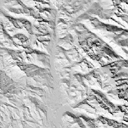
CHILI — это модель, заменяющая влияние инсоляции и топографического затенения на эвапотранспирацию, которая рассчитывается путем вычисления инсоляции в начале дня, на высоте солнца, эквивалентной равноденствию. Она основана на 30-метровом диапазоне "AVE" цифровой модели рельефа ALOS JAXA (доступна в Европе как JAXA/ALOS/AW3D30_V1_1).
Наборы данных по экологически значимой геоморфологии (ERGo) организации Conservation Science Partners (CSP), содержащие подробные многомасштабные данные о формах рельефа и физиографических (или ландшафтных) особенностях ландшафта, содержат подробную информацию о формах рельефа и физиографических (или поверхностных) структурах. Хотя существует множество потенциальных применений этих данных, их первоначальная цель заключалась в разработке экологически значимой классификации и карты форм рельефа и физиографических классов, подходящих для планирования адаптации к изменению климата. Поскольку существует большая неопределенность, связанная с будущими климатическими условиями, и еще большая неопределенность в отношении экологических реакций, предоставление информации о том, что вряд ли изменится, обеспечивает прочную основу для разработки надежных планов адаптации к изменению климата. Количественная оценка этих характеристик ландшафта зависит от разрешения, поэтому мы предоставляем максимально возможное разрешение, учитывая масштабы и характеристики данного индекса.
Группы
Группы
Размер пикселя: 90 метров (все диапазоны)
| Имя | Мин | Макс | Размер пикселя | Описание |
|---|---|---|---|---|
constant | 0 | 255 | 90 метров | Индекс CHILI, полученный на основе данных ALOS, варьируется от 0 (очень холодно) до 255 (очень тепло). Он был масштабирован из диапазона [0,1], представленного в публикации. |
Условия эксплуатации
Условия эксплуатации
Цитаты
Теобальд, Д.М., Харрисон-Атлас, Д., Монахан, В.Б., и Альбано, К.М. (2015). Экологически значимые карты рельефа и физиографического разнообразия для планирования адаптации к изменению климата. PloS one, 10(12), e0143619
Исследуйте мир с помощью Earth Engine.
Редактор кода (JavaScript)
var dataset = ee.Image('CSP/ERGo/1_0/Global/ALOS_CHILI');
var alosChili = dataset.select('constant');
var alosChiliVis = {
  min: 0.0,
  max: 255.0,
};
Map.setCenter(-105.8636, 40.3439, 11);
Map.addLayer(alosChili, alosChiliVis, 'ALOS CHILI');