- ডেটাসেট উপলব্ধতা
- 2006-01-24T00:00:00Z-2011-05-13T00:00:00Z
- ডেটাসেট প্রদানকারী
- সংরক্ষণ বিজ্ঞান অংশীদার
- ট্যাগ
বর্ণনা
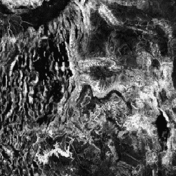
টপোগ্রাফিক ডাইভারসিটি (ডি) হল একটি সারোগেট পরিবর্তনশীল যা স্থানীয় আবাসস্থল হিসাবে প্রজাতির জন্য উপলব্ধ তাপমাত্রা এবং আর্দ্রতার বিভিন্ন অবস্থার প্রতিনিধিত্ব করে। এটি যুক্তি প্রকাশ করে যে টপো-জলবায়ু কুলুঙ্গির একটি উচ্চতর বৈচিত্র্যকে সমর্থন করা উচিত (বিশেষ করে উদ্ভিদ) এবং জলবায়ু পরিবর্তনের প্রেক্ষিতে প্রজাতির অধ্যবসায়কে সমর্থন করা উচিত।
D গণনা করার জন্য, মাল্টি-স্কেল টপোগ্রাফিক পজিশন ইনডেক্স (mTPI), মাটির আর্দ্রতা (T) একটি প্রভাবশালী নিয়ন্ত্রণ হওয়ায়, পাহাড়ের ঢালের অবস্থান পরিমাপের জন্য ব্যবহৃত হয়েছিল। mTPI কে mTPI>0 (T') এর জন্য বর্গ-মূল রূপান্তরের সাথে এবং ক্রমাগত হিট-ইনসোলেশন লোড ইনডেক্স (CHILI) এর মানক বিচ্যুতির সাথে একত্রিত করা হয়েছিল, যা একাধিক স্কেলে (C') হিসাবে গণনা করা হয়েছিল: D = 1 - ((1-T') * (1-C')। এটি 30m JAV 30m JAV "EM" ব্যান্ডের উপর ভিত্তি করে তৈরি করা হয়েছে। (EE-এ JAXA/ALOS/AW3D30_V1_1 হিসাবে উপলব্ধ)।
কনজারভেশন সায়েন্স পার্টনারস (সিএসপি) পরিবেশগতভাবে প্রাসঙ্গিক জিওমরফোলজি (ইআরজিও) ডেটাসেট, ল্যান্ডফর্ম এবং ফিজিওগ্রাফিতে ল্যান্ডফর্ম এবং ফিজিওগ্রাফিক (ওরফে ল্যান্ড ফেসেট) প্যাটার্নের বিস্তারিত, বহু-স্কেল ডেটা রয়েছে। যদিও এই ডেটাগুলির অনেকগুলি সম্ভাব্য ব্যবহার রয়েছে, এই ডেটাগুলির মূল উদ্দেশ্য ছিল একটি পরিবেশগতভাবে প্রাসঙ্গিক শ্রেণীবিভাগ এবং ল্যান্ডফর্ম এবং ফিজিওগ্রাফিক ক্লাসগুলির মানচিত্র তৈরি করা যা জলবায়ু অভিযোজন পরিকল্পনার জন্য উপযুক্ত। কারণ ভবিষ্যত জলবায়ু পরিস্থিতির সাথে বড় অনিশ্চয়তা এবং পরিবেশগত প্রতিক্রিয়াগুলির চারপাশে আরও অনিশ্চয়তা রয়েছে, যা পরিবর্তনের সম্ভাবনা নেই সে সম্পর্কে তথ্য সরবরাহ করা পরিচালকদের শক্তিশালী জলবায়ু অভিযোজন পরিকল্পনা তৈরি করার জন্য একটি শক্তিশালী ভিত্তি সরবরাহ করে। ল্যান্ডস্কেপের এই বৈশিষ্ট্যগুলির পরিমাপ রেজোলিউশনের প্রতি সংবেদনশীল, তাই আমরা প্রদত্ত সূচকের ব্যাপ্তি এবং বৈশিষ্ট্যের ভিত্তিতে সর্বোচ্চ রেজোলিউশন প্রদান করি।
ব্যান্ড
পিক্সেল সাইজ
270 মিটার
ব্যান্ড
| নাম | মিন | সর্বোচ্চ | পিক্সেল সাইজ | বর্ণনা |
|---|---|---|---|---|
constant | 0* | 1* | মিটার | ALOS-প্রাপ্ত টপোগ্রাফিক বৈচিত্র্য |
ব্যবহারের শর্তাবলী
ব্যবহারের শর্তাবলী
উদ্ধৃতি
Theobald, DM, Harrison-Atlas, D., Monahan, WB, & Albano, CM (2015)। জলবায়ু অভিযোজন পরিকল্পনার জন্য ল্যান্ডফর্ম এবং ফিজিওগ্রাফিক বৈচিত্র্যের পরিবেশগতভাবে প্রাসঙ্গিক মানচিত্র। PloS one, 10(12), e0143619
আর্থ ইঞ্জিন দিয়ে অন্বেষণ করুন
কোড এডিটর (জাভাস্ক্রিপ্ট)
var dataset = ee.Image('CSP/ERGo/1_0/Global/ALOS_topoDiversity');
var alosTopographicDiversity = dataset.select('constant');
var alosTopographicDiversityVis = {
  min: 0.0,
  max: 1.0,
};
Map.setCenter(-111.313, 39.724, 6);
Map.addLayer(
    alosTopographicDiversity, alosTopographicDiversityVis,
    'ALOS Topographic Diversity');