- Доступность набора данных
- 2006-01-24T00:00:00Z–2011-05-13T00:00:00Z
- Поставщик наборов данных
- Партнеры по науке сохранения природы
- Теги
Описание
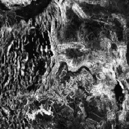
Топографическое разнообразие (D) — это суррогатная переменная, отражающая разнообразие температурных и влажностных условий, доступных видам в качестве локальных местообитаний. Она отражает логику, согласно которой большее разнообразие топоклиматических ниш должно способствовать большему разнообразию (особенно растений) и способствовать выживанию видов в условиях изменения климата.
Для расчета D использовался многомасштабный индекс топографического положения (mTPI), являющийся основным фактором, определяющим влажность почвы (T), для измерения положения склона холма. Значение mTPI было объединено с квадратно-корневым преобразованием для mTPI>0 (T') и со стандартным отклонением индекса непрерывной тепловой нагрузки (CHILI), рассчитанным в нескольких масштабах (C') по формуле: D = 1 - ((1-T') * (1-C'). Он основан на 30-метровом диапазоне "AVE" цифровой модели рельефа ALOS (доступной в EE как JAXA/ALOS/AW3D30_V1_1).
Наборы данных по экологически релевантной геоморфологии (ERGo), формам рельефа и физиографии, разработанные Conservation Science Partners (CSP), содержат подробные многомасштабные данные о формах рельефа и физиографических (т.н. «фасетных» характеристиках рельефа). Несмотря на множество потенциальных применений этих данных, изначальной целью их создания была разработка экологически релевантной классификации и карты форм рельефа и физиографических классов, подходящих для планирования адаптации к изменению климата. В связи с высокой неопределенностью, связанной с будущими климатическими условиями, и еще большей неопределенностью, связанной с экологическими реакциями, предоставление информации о том, что вряд ли изменится, дает руководителям надежную основу для разработки надежных планов адаптации к изменению климата. Количественная оценка этих характеристик ландшафта чувствительна к разрешению, поэтому мы предоставляем максимально возможное разрешение с учетом масштаба и характеристик данного индекса.
Группы
Размер пикселя
270 метров
Группы
| Имя | Мин. | Макс | Размер пикселя | Описание |
|---|---|---|---|---|
constant | 0* | 1* | метров | Топографическое разнообразие, полученное с помощью ALOS |
Условия эксплуатации
Условия эксплуатации
Цитаты
Теобальд, Д.М., Харрисон-Атлас, Д., Монахан, У.Б., и Альбано, К.М. (2015). Экологически значимые карты рельефа и физико-географического разнообразия для планирования адаптации к изменению климата. PloS one, 10(12), e0143619
Исследуйте с Earth Engine
Редактор кода (JavaScript)
var dataset = ee.Image('CSP/ERGo/1_0/Global/ALOS_topoDiversity');
var alosTopographicDiversity = dataset.select('constant');
var alosTopographicDiversityVis = {
  min: 0.0,
  max: 1.0,
};
Map.setCenter(-111.313, 39.724, 6);
Map.addLayer(
    alosTopographicDiversity, alosTopographicDiversityVis,
    'ALOS Topographic Diversity');